Share
David Viner, Alasdair Smith and David Gold consider how geospatial data can help to optimise land use and mitigate climate change risk.
The Intergovernmental Panel on Climate Change (IPCC) has just concluded its Sixth Assessment Report Cycle (AR6). The reports making up the AR6 provide the most comprehensive overview of the current state of climate change, its impacts and the adaptation and mitigation options that are available.
The IPCC has been clear on the urgency that is required to meet the targets of the Paris Agreement. We have no more than seven years and probably only three to start drastically reducing emissions of greenhouse gases. If we do not, global temperature change will reach the 1.50C threshold after which climate change impacts will become increasingly more dangerous and difficult to adapt to.
As well as the three major AR6 reports, three special reports were produced, including the Special Report on Climate Change and Land (SRCCL), which emphasised the use of the land as a key resource. Currently, land provides the principal basis for human livelihoods and well-being, including the supply of food, freshwater and multiple other ecosystem services, as well as biodiversity. Human use directly affects more than 70% of the global, ice-free land surface. Land also plays a vital role in both moderating and amplifying the climate system and this has larger impacts at regional and local scales. Currently, up to one third of land’s potential net primary production is used for food, feed, fibre, timber and energy by people. Land provides the basis for many other ecosystem functions and services to support human activity. In one economic assessment, the world’s terrestrial ecosystem services have been valued on an annual basis to be approximately equivalent to the annual global gross domestic product of the world.
Climate change is projected to alter land conditions through feedbacks on regional climate. For example, in boreal regions where the treeline migrates northward and the growing season lengthens, winter warming will be enhanced due to decreased snow cover and albedo, while warming will be reduced during the growing season due to increased evapotranspiration. In tropical areas where increased rainfall is projected, increased vegetation growth will reduce regional warming. Drier soil conditions resulting from climate change can increase the severity of heat waves, while wetter soil conditions have the opposite effect.
How geospatial can help
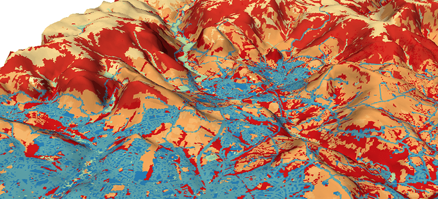
Planning and regulation can achieve positive adaption and mitigation outcomes. For example, incentives such as payment for ecosystem services, and voluntary or persuasive instruments such as environmental farm planning, standards for sustainable production, use of scientific, local and indigenous knowledge. Measuring and monitoring land use change, including land degradation and desertification, is supported by the expanded use of new information and communication technologies, climate services, and remotely sensed land and climate information. These include growing geospatial data sources from rapidly expanding and powerful earth observation satellite missions, ground-based sensors and UAV imagery that when expertly processed and analysed can provide data-driven intelligence and derived environmental insights such as natural capital, biodiversity and land use.
Specialist information layers derived from geospatial data are essential contributors to optimising land use to mitigate climate change risks and impacts. Loading structured data into data warehouses using easily accessible GIS tools, geospatial software, and computer programming allows for advanced geospatial analysis.
A variety of raw land, environmental and socioeconomic spatial data, coupled with business and other strategic information, can be analysed to provide focused insights. These can help deliver actionable science-based solutions to climate-related challenges such as land use options that deliver carbon sequestration in soil or vegetation. These options can include afforestation, reforestation, agroforestry, soil carbon management on mineral soils, carbon storage in harvested wood products, or restoration of peatland, salt marsh, seagrass and mangrove habitats. The analysed data can be integrated to evaluate sites on their natural capital and potential for carbon offsetting, renewable energy infrastructure, and nature-based solutions.
An essential starting point for land use assessment using geospatial data is to identify appropriate factor and constraint layers to incorporate into a land use assessment model. Factor layers may include topographic, climate, land use, infrastructure, socio- economic, and cultural criteria. Constraint layers delineate those areas for which specific types of land development may be restricted or prohibited. These may include zones under ecological protection or areas where a particular form of land use designation is deemed inappropriate for other reasons. For example, a site suitability assessment for onshore wind farm installation may exclude urban/built-up areas from further consideration. Ultimately, decisions on the appropriate factor and constraint layers to incorporate will be driven by scientific knowledge, regulatory frameworks, politics and stakeholder preferences. In any case, all criteria chosen must sufficiently consider the growing pressure on land use due to climate and environmental change.
Many new monitoring insights can be gained by combining and analysing multi- temporal geospatial data in new and unique ways that are designed in consultation with industry regulators and supported by domain expertise. Examples of these include multi-criteria decision analysis (MCDA) and use of machine learning (ML). MCDA provides a flexible framework in which multiple – and possibly conflicting – criteria can be simultaneously evaluated when assessing the suitability of an area for a particular purpose. By properly defining and structuring a complex problem, diverse sets of criteria can be evaluated explicitly within a dynamic and regional weighting scheme, and more robust and better-informed decisions can be made. ML approaches can be used to complement more traditional land classification techniques and, in some cases, may be a more appropriate alternative owing to their greater efficiency and improved classification subjectivity. One method is to use supervised classification ML models, such as gradient boosting, on landscape features which have contrasting physical, spectral, and topographic characteristics, whereby new decision trees are sequentially added to correct the errors made by existing models until no further improvements can be made.
These new insights have substantial potential to help clients satisfy their corporate responsibility obligations and aspirations to mitigate climate change and enhance nature by directly supporting the recommendations of the IPCC through optimising land use for renewable energy sources and nature- based solutions. It is our view that geospatial data-led solutions will help inform any given client’s interpretation of their stewardship duties to achieve their net-zero ambitions.
David Viner is head of environmental science, Alasdair Smith is geospatial data scientist and David Gold is environmental science – technical business development lead at CGG (cgg.com)


