Share
Jerome Jones reports on at an innovation that exploits satellite-borne Synthetic Aperture Radar (SAR) to monitor bridges remotely and at scale
Bridges are infrastructure assets that are vital to our everyday life. They help us cross boundaries, connect people, and transport goods; and as with all critical infrastructure, they need careful and regular maintenance. Many bridges are in urgent need of refurbishment and face challenges of limited capital investment and inflexible inspection and maintenance regimes.
Factors such as climate change, heavy usage, and age can all affect the structural health of bridges, and eventually lead to damage or collapse. To guard against such events, bridges are generally inspected every two years to identify structural problems and plan for their remediation. However, difficulties can often arise when inspecting hard to reach locations or when attempting to identify invisible signs of deterioration. In addition, the frequency of inspections can be insufficient to tackle escalating problems.
How satellites can help
Synthetic Aperture Radar (SAR) satellites are a type of Earth Observation (EO) satellite that can deliver up to 25cm resolution data which, unlike optical data, is unaffected by weather factors such as cloud cover. SAR data has been used for over two decades for producing ground motion maps, and this successful method of monitoring change is now being applied to detecting slight movements in ground structures.
As with all data, SAR provides its own benefits but can be complemented by other datasets such as ground sensors to provide an even better service to users.
Real-time monitoring
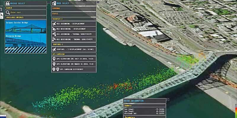
BRIGITAL processes and analyses data from a range of sources, including satellites, ground sensors, and visual inspections, and displays any vertical displacement of bridges over time with millimeter accuracy. This real-time monitoring can aid users in deciding when and where to focus resources to pre-empt large scale damage or collapses.
The visualisation tool displays the changes in structure and is developed as an early-warning tool, comparing automatically predicted movements against satellite measurements and indicating potential problems to users, thus allowing for early intervention.
The images above left taken from the BRIGITAL visualisation tool show relative displacements of the Jacques Cartier Bridge and Victoria Bridge, Canada
Jerome Jones is Head of Geospatial Technology with the Satellite Applications Catapult, based at Harwell, Didcot, Oxfordshire (www.sa.catapult.org.uk)


