Share
Alexander Reiterer explains how a reservoir basin in Germany was completely surveyed in 3D using several mobile mapping techniques.
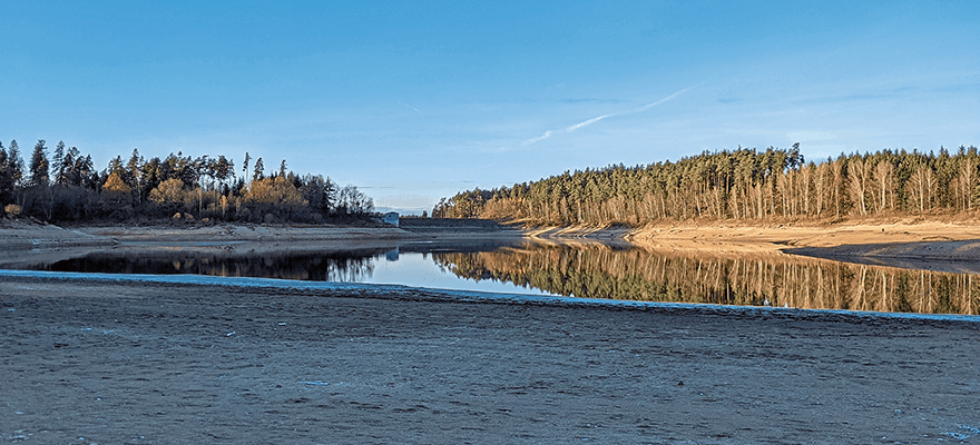
Dams and reservoirs are some of the most closely monitored structures. However, traditional methods for surveying the basin of a reservoir are very time consuming, laborious and provide comparatively inaccurate data. Together with a surveying service provider, Fraunhofer IPM has now conducted a survey of 100% of the Liebensteinspeicher reservoir in Germany’s Upper Palatinate region. The resulting high-precision 3D data provides insights into the reservoir volume, the water table area, and the depth of the lake.
Reservoir lakes have multiple functions:
They protect people from flooding, facilitate
river and stream runoff in dry conditions,
generate energy, provide a habitat for flora
and fauna, and sometimes even supply
drinking water. That said, trapping so
much water also poses certain dangers; the consequences of climate change such
as heavy rainfalls or droughts only further
emphasise these risks. Therefore, strict
safety regulations are in place for these
structures, and operators must conduct regular, in-depth inspections – a regular full
survey of the basins being one of them.
These surveys are rather complex and time-consuming. First, reservoir lakes are almost always filled with water: A full drainage can take several weeks, and animals living in the lake would have to be fished or taken out. As a result, surveys usually take place while there is water in the basin – which means they must combine both methods for underwater measurement and methods for measuring the shores and other areas above the water. What is more, the embankments of these lakes are often steep and overgrown by plants, which makes them difficult to access. Retrieving sufficient and reliable data of these areas is therefore not an easy task.
Thanks to new measurement techniques, it has now become possible to collect high-precision 3D data on the condition and volume of reservoirs. These modern approaches gather data using different techniques and combine them into 3D models of the lakes, allowing providers to create accurate volume calculations which serve as a basis of risk scenarios.
Full survey with echo sounder and LiDAR
At the German Liebensteinspeicher reservoir, Fraunhofer IPM and its project partner GeoGroup GmbH have conducted such a full survey, combining multiple high-end measurement techniques. The result is a 100% image of the water bottom, which has a catchment area of 74.6km2 and a shoreline of approximately 6km. The lake had been partly drained, so the project partners used different measuring methods to gather the data.
For the surveying of the basin, GeoGroup used a mobile mapping system fitted with an echo sounder and mounted on a boat. The boat and the mobile mapping system were equipped with inertial systems for positioning and compensating for the ship’s movements. The echo sounder scans the bottom of the lake emitting a measuring beam 20 to 50 times per second. Each emission of the beam provides 1,024 measuring points while the two separate rotating lasers of the mobile mapping system capture 35,000 measuring points per second. With their equipment, the team retrieved a highly accurate set of data of the lake and the basin in less than a day.
In order to further enhance measurement accuracy, Fraunhofer IPM used its Lightweight Airborne Profiler to fill gaps within the data provided by the sonar system. The measurement system consists of a laser scanner, several cameras and a positioning sensor, which are all characterised by their ultra-lightweight design and can be fitted to a drone. Local positioning is based on a combination of inertial measurement unit and GNSS. Cameras are used to ensure orientation in case of shaded and complex structures with poor or no GNSS reception. The accruing data is written to a USB device. The device can be exchanged quickly, making it possible to work almost without interruptions. Using the time-of-flight technique, the LAP detects up to 32 profiles in a second – each of them containing up to 1,000 points. Even though the conditions were not ideal due to cold weather, strong winds and swampy areas, the team was able to obtain highly accurate data of the lake within few measuring flights.
In contrast to photogrammetric methods the system provides a comprehensive image where the data is directly mapped in the coordinate system, eliminating the need for complex image processing. To raise the positional accuracy of the data, the GNSS data is corrected using the data of the German satellite positioning service SAPOS. The subsequent evaluation and colourisation of the point cloud is done by software developed by Fraunhofer IPM.
High-precision data by combining two systems
The combination of the different methods presents several advantages: Surveying on the water and from the air at the same time allows for precise measurements of even the most inaccessible places, such as steep embankments or overgrown areas. As a result, the team was able to retrieve four million measuring points in places where traditional methods may only have produced four of them. Furthermore, the extensive data from both systems overlap. This enabled the project partners to produce particularly accurate calculations, minimizing the risk of incorrect estimations.
For the validation of the retrieved data, the team used the BeamworX AutoClean software. Since all systems in use recorded the data directly in the UTM coordinate system, the various data sets could immediately be merged in the software without further processing, making it possible to match and evaluate the immense amount of data within few seconds. With the validated, merged and cleaned data, the team created a full 3D model of the reservoir and curves for the water level and the volume of the lake. By combining the model and the curves, an accurate filling level curve for the lake was calculated, providing the local authorities with highly accurate data of the lake, its volume, its water table area and its depth.
Professor Dr Alexander Reiterer is head of the Department of Object and Shape Detection at the Fraunhofer Institute for Physical Measurement Techniques IPM (www.ipm.fraunhofer.de)


