Share
This romantic ruin, perched high above the River Avon in Warwickshire, was a compelling subject for a photorealistic digital twin … one that provided an entertaining and immersive VR experience. All it needed was the ambition and the technology to bring it to life
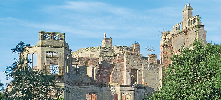
Dating to the mid-18th century, the ruin of Guy’s Cliffe House near Warwick is characterised by its Palladian Georgian architectural detail. Like many visitors throughout the years, Alex Harvey enjoyed exploring its grounds as a child during public open days – only to return many years later as co-founder of UK VR asset developer RiVR1 with an ambitious plan: to create a digital twin and immersive VR experience of this enchanting, romantic ruin.
After working around the world developing photorealistic scanning techniques, Harvey approached the site owner with a proposal to include Guy’s Cliffe House in RiVR’s documentary project STEPiNSiDE … one that combines entertainment, exploration and immersive storytelling to offer users an even closer look at historical landmarks and sites of interest than normal documentary practices would allow.
In order to achieve the goal of creating a photorealistic digital twin of Guy’s Cliffe House, RiVR partnered with Leica Geosystems, part of Hexagon, to deploy the latter’s advanced laser scanning technology solutions and software. This would allow it to develop a point cloud for use in VR, 2D mixed reality, 360 video and 2D documentary.
Creating a photorealistic digital twin
Photogrammetry – the science of obtaining information on physical objects and the environment by recording, measuring and interpreting photographic images and patterns – is instrumental to RiVR’s work and its reason for choosing the latest laser scanning technology to help deliver the best results possible.
The Leica Geosystems RTC360 3D laser scanner2 – selected by Harvey for its portability, ease of use, speed and accuracy – allowed the team to capture 100Gb of raw data across 153 scans.
Furthermore, the handheld imaging laser scanner Leica BLK2GO3 helped deliver additional data with Simultaneous Localisation and Mapping (SLAM) technology.
With a measuring rate of up to two million points per second and an advanced HDR (High-Dynamic Range) imaging system, the creation of coloured 3D point clouds was completed in less than two minutes and visualised immediately in the field using Leica Cyclone FIELD 3604. Thanks to automated targetless field registration based on VIS (Visual Inertial System) technology, and the seamless, automated transfer of data from the Guy’s Cliffe House site to the RiVR office, the scanning project was complete in just one day.
What next
Having scanned and filmed in only a few of its locations, Harvey and his team plan to expand the project at Guy’s Cliffe House in 2022 and explore more of the grounds – including the secret tunnels of Warwick5 that are rumoured to have started from this location.
RiVR has also started working with Warwick Castle and the Lord Leycester Hospital in Warwick and where, again, it is using Leica Geosystems laser scanning technology to help bring exhibits and artifacts to life with VR and AR.
References
2. https://leica-geosystems.com/p...
3. https://shop.leica-geosystems....
4. https://leica-geosystems.com/p...
5. http://youtu.be/02ynEyvrlAM
Footnote
The supporting videos from this project can be viewed online at:
Guy’s Cliffe House, Warwick in VR
(http://www.youtube.com/watch?v=wCnjbw2HpQg&t=4s)
Lidar scan of Guy’s Cliffe House Warwick
(http://www.youtube.com/watch?v=Rw5W7f1ScGo)
How to create VR worlds of real life places | The Gadget Show (http://www.youtube.com/watch?v=Lmvtp1PVtPA)


