Share
Equipping a UAV with a higher-resolution camera provides far more benefits for oil and gas surveys than simply better pictures.
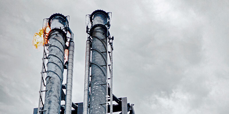
The flare is a vital part of the safety system in an oil and gas production facility. Amongst other things, it is used to burn off unwanted gas. It is therefore of utmost importance that flares are working faultlessly.
The ensure optimal working conditions, flares are regularly assessed and inspected for defect analysis. These reports can then be archived for comparison with future inspections for an even more accurate survey and reliable monitoring of any potential issues.
UAV inspections offer unprecedented visual access to hard-to-reach areas during flare stack inspections. They also dramatically reduce costs, as the processing plant and flare system can remain fully operational, thereby helping to prevent major events, such as scheduled shutdowns or unusual flaring events.
The flare stack inspections deployed by SkyeBase, an inspection service provider based in Belgium, use UAV technologies capable of capturing a full 360° perspective of the asset, while also enabling the inspection team to focus on specific areas such as the flare tip, radiation shield, pilot ignition systems, pipework, gantries and handrails, and giving a general overview of the flare stack condition.
In addition to significantly reducing inspection time and cost, UAV-based inspection immensely reduces the risks as no inspection team personnel needs to be working at height in dangerous conditions.
Flare stack inspection
In December 2021, SkyeBase was tasked by a multinational oil and gas company with conducting an inspection for the structural evaluation, condition assessment and technical analysis of live flare stacks located in the port of Antwerp.
By taking overview photos from a distance, the team could analyse them in the office afterwards. This greatly reduced downtime and time on the site, as well as increased quality and efficiency. Due to the high quality of the images, a safer distance from certain critical assets can be maintained. This increases safety and makes risk analysis for flights easier.
It was also possible to inspect damages at a millimetre-level. Assets could be viewed more closely and in greater detail. This allowed for faster identification of areas of concern for routine maintenance and reduced the cost of downtime.
By taking the same picture at the same location and the same angle every time, assets can be monitored very efficiently, even in difficult external conditions. They can also be re-accessed and continuously monitored for defect analysis. These reports can then be archived for comparison with future inspections for an even more accurate survey and reliable monitoring of any potential issues.
Mapping and 3D modelling
A high-resolution camera has more pixels and a larger sensor. This makes it possible to fly higher and take fewer pictures while maintaining the same accuracy. In this way, the flight time is reduced and the presence on site is shorter. When flying in a similar way, the quality is significantly higher.
Table 1 provides an overview of the ground sampling distances at the same altitude – the lower the number, the higher the accuracy.
| Altitude | DJI Zenmuse P1
(43MP, 35mm) | Phase One P3
(100MP, 35mm) | Phase One P3
(100MP, 150mm) |
|---|---|---|---|
| 40m | 0.50cm/px | 0.43cm/px | 0.10cm/px |
| 80m | 1.00cm/px | 0.86cm/px | 0.20cm/px |
| 100m | 1.26cm/px | 1.08cm/px | 0.25cm/px |
High-resolution images can also be used to create 3D models. With a shorter data capture time, more points can be created for the point cloud. The general benefits offered by 3D models include
- Localisation of damage
- Volume measurement
- Generation of plans
This makes assessments much easier.
Advantages of Phase One’s P3 Payload solution
The P3 with its 100MP camera has the advantage of doing inspections and mappings on site much faster and from a higher and safer distance. This significantly reduces potential downtime and risks associated with manual inspection. Due to the high resolution, images contain much more detail, and point clouds have a much higher accuracy.


