Share
As organisations world-wide struggle to harness the power of their data at scale, 1Spatial’s Bob Chell examines how Location Master Data Management is helping them make the right call

The Data Decision Gap is the inability to leverage your data to make accurate and trusted decisions. A study by Quantexa* found that “50% of strategic decisions are missing crucial intelligence because organizations can’t take full advantage of data”.
1Spatial knows the importance of accurate and complete data sets and understands how they can enable organisations to make confident data-based decisions, leveraging the hidden value of their data. So how do you go about creating a complete and connected dataset? Start with what you know, and innovate from there.
Start with what you know
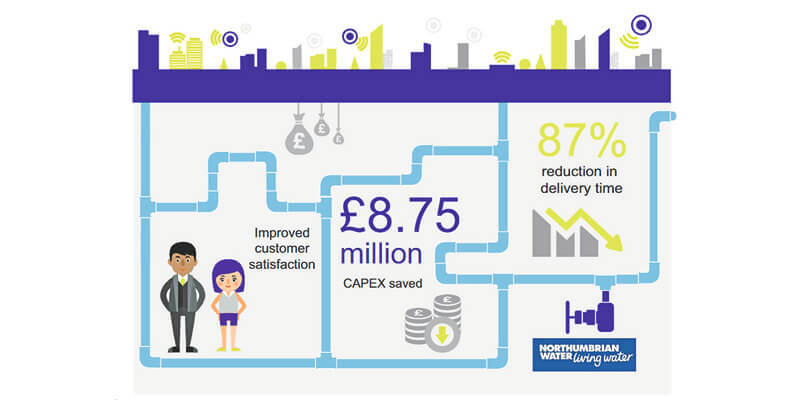
In 2011, the government transferred ownership of all private drains and sewers in England to local water companies. As a result, Northumbrian Water (NWL) assumed responsibility for an estimated 13,500 km of additional wastewater pipes. Information on this historic infrastructure, however, was extremely limited, with estimates suggesting only 5% coverage. There was very little information available on the make-up of the assets: materials, size of pipe etc. Without good data, NWL would find it difficult to meet its regulatory targets for customer service and to plan effective maintenance and investment. Effectively, it had encountered the data decision gap.
NWL calculated it would take around 15 years to complete the missing information using traditional survey techniques, costing £10 million in the first 5 years alone. 1Spatial stepped in with an innovative approach, using available information to create a set of data rules to infer what the missing information should be. Rules were created to infer important attributes that included location, construction, direction of flow and usage.
The £1.25 million cost, compared to the original planned cost for the first five years, represents an 87% saving. By having the network fully mapped in around 1/8 of the time, NWL will more quickly reach its goals of even better customer service and more informed investment and maintenance plans.
Link up data sets
Location offers a unique data perspective for uniting disparate assets across internal and external datasets. Geometric and topological relationships have always been powerful techniques with which to link data and describe relationships in spatial assets. In the same way, graph databases are popularly used to store links and relationships between non-spatial assets.
For many years now, the Unique Property Reference Number (UPRN) has been a unique code for every addressable location in Great Britain, made available to public sector organisations for free via the Public Sector Geospatial Agreement. It provides a clear code for an undisputed reference of a location. Many organisations look to tag their location data with the associated UPRN where possible, as this then becomes a valuable key that can be used to link to other datasets and systems.
By re-using existing location data, working out the rules to define how we can create missing UPRNs where they could exist, or validating existing UPRNs so we are confident in their accuracy, we can establish relationships between previously siloed data sets – almost for free. New insights created from this previously untapped, joined-up view of the system can then spark imaginative and innovative ways for us to improve what we do and how we do it.
Our recent work with Police Location Data is a real-world example of this. Police forces hold crucial information that needs to be trusted and readily available, but this data is often held in many different places. Only once the data sets have been linked up, can valuable insight be gained. For all emergency services, tying multiple pieces of data to one location is key. By using the UPRN to ensure that incidents are recorded in the correct location, hotspots of repeated incidents can be produced, enabling senior management to predict future incidents and prioritise resource distribution.
A location approach to MDM
1Spatial understands that many organisations work with disparate datasets that may be held in silos, in different formats and in different systems for different purposes. Often, an organisation’s systems architecture contains overlapping profiles of information about the same physical entities.

By auditing, cleansing, synchronising, updating and analysing different data sets, Location Master Data Management (LMDM) delivers significant cost and time savings and, crucially, data that can be trusted and relied upon.
This automated, cyclical approach helps us address the top three effects of the data decision gap (as identified by Quantexa and CDI*).
Regulatory scrutiny: Data Governance helps solve regulatory compliance issues an organisation may face, and to proactively manage any risks and opportunities that arise.
Part of this means establishing a solid process and foundation, beyond focusing on the tools being used. This is often supported by familiar techniques as found in quality standards such as ISO 9001.
Data growth is only accelerating, so ensuring effective data governance means you can trust your data, and be ready for what the future holds.
Missed customer experience opportunities and retention problems: A cyclical approach to LMDM focuses on continuous improvement, analysing risks and opportunities throughout the process.
Joining up data, systems and experience can provide a new perspective that sparks off innovation. You can’t address problems if you can’t see them, and you don’t know what opportunities are available until you can see the full picture!
In 2020, the Environment Agency partnered with 1Spatial to create a Data Rules Library to automatically verify and validate geoCOBie sheets. Its single-source-of-truth repository will develop into a digital twin for physical assets - the perfect platform for innovation.
Resource drainage due to increased manual data workload: Automation is a great way to reduce resource drainage and improve efficiency. Maintaining a rules library using 1Spatial’s patented 1Integrate rules engine allows for automation at any scale. For example, the company’s Traffic Management Plan Automation solution can automate the production of simple Traffic Management Plans, freeing up expert resources to focus on the complicated plans that really require manual attention.
Automation has the added bonus of offering heightened security – minimising manual data handling reduces risk of human error whilst also respecting ethical responsibilities.
The bottom line
“95% of organizations suffer from the data decision gap, which is the inability to bring together the internal and external data needed to make accurate and trusted decisions. This is due to inaccurate and incomplete datasets, which ultimately impact the bottom line.”*
The National Underground Asset Register (NUAR) is another exciting example of collaborating to bridge the data gap. Data relating to underground assets is held in many different repositories, formats and locations. Asset owners have different ways of capturing and storing data making the quality inconsistent. Building a trusted Asset Register is crucial to reduce utility strikes, and improve efficiency and safety. The cost-savings of this project have been estimated at £347 million a year, over 10 years.
As the data gap continues to grow, organisations are struggling to harness the power of their data at scale. 1Spatial’s Location Master Data Management (LMDM) software and solutions revolutionise this process, delivering significant time and cost savings whilst crucially giving organisations confidence and trust in their data. By providing a real-world understanding of their challenges and opportunities, it delivers accurate and valuable information to users and customers for a safer, smarter world.
* Quantexa, CDI, “Data Decision Gap risks holding back economic recovery, global research finds” 9 Nov 2021
Bob Chell is Chief Product Officer and Chief Operating Officer for Location Master Data Management solutions provider 1Spatial (https://1spatial.com) headquartered in Cambridge, England


