Share
GeoConnexion talks to Alexey Dobrovolskiy, CTO and co-founder of SPH Engineering, about the challenges and opportunities for drone-enabled bathymetry in shallow waters
GeoConnexion (GEO): Bathymetry techniques and devices have traditionally been developed for use in deeper waters. How have you adapted these to accommodate accurate surveys of rivers, lakes, wetlands, lagoons, estuaries and other shallow waters?
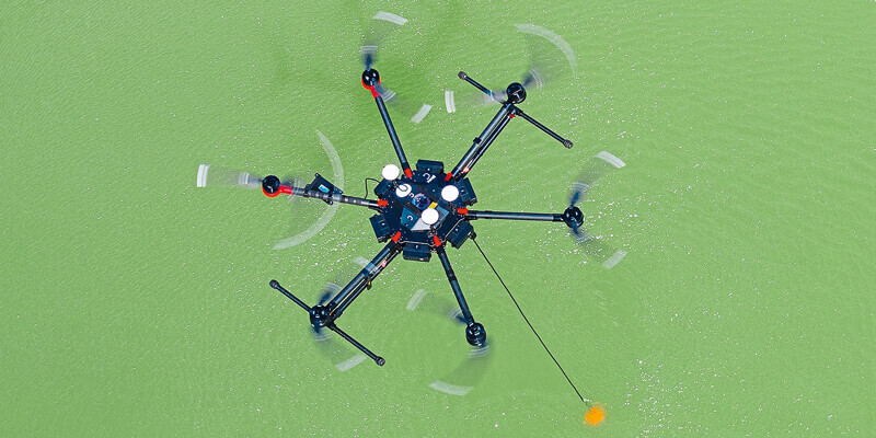
Alexey Dobrovolskiy (AD): Although echo sounders are nothing new and have been used on unmanned surface vehicles and for “manned” surveys over many years, it was really by luck that we found lightweight survey-grade echo sounders suitable for deployment by a UAV on a suspended rope. These sensors have a minimal dead zone of around 15cm - allowing a practical minimum measured depth of around 30cm as they must be submerged when operating.
There are challenges, of course. Such sensors on the rope are not very stable when deployed and, to overcome this, we use additional stainless steel tubes to increase their weight and stability. Maintaining a set altitude over the water surface can also be problematic, but we had already solved this for other geophysical sensors (GPR, magnetometers, and metal detectors) that need to operate at fixed distances.
GEO: Do you foresee drone-enabled bathymetry replacing or supplementing traditional survey methods?
AD: We consider UAV-based bathymetry as a supplementing tool - or as the only choice when traditional methods don’t work.
If you already have an Unmanned Surface Vehicle (USV) with an echosounder, and can deploy and use it in a survey area, you don’t need a drone to do bathymetric surveys. However, it is important to use the right tool for the right task. A drone with an echo sounder is especially effective if one needs to make small-scale surveys in areas where the use of other tools is impossible or complicated.
We have found some real-world situations where the drone-deployed echo sounder can have great value. First of all - if you can’t deploy an USV for some practical reason, e.g. lack of physical access, then a drone-based solution allows you to do bathymetric surveys remotely. Another consideration is that the transportation, deployment and application of drones is a pretty simple process. A medium-sized drone with an echo sounder can be transported in any car and deployed by one person in minutes.
Last but not least. If you need or want to do bathymetric surveys but don’t have an USV, purchasing a drone with an echo sounder system will be at least half the cost of an USV with an autopilot and echosounder of the same quality and precision. If you already have an appropriate drone, you will save at least two thirds of the cost.
GEO: Fully autonomous drones are said to be the “next big thing” in maritime surveying. Does your work on Artificial Intelligence and Machine Learning bring this closer?
AD: Yes. Our ATLAS (https://atlas.ugcs.com/) data analytics system is based on AI and Machine Learning. We are also developing GPR data analysis using AI. We already have some good examples of how ATLAS can be used to analyse the data gathered using side-scan sonars (https://atlas.ugcs.com/news/tp...;
GEO: The United States is currently your largest market outside Europe. Do you see this changing in the medium-to-long term?
AD: The current situation is that the USA is a huge market in itself and businesses there are quick to adopt new technologies. There are no significant language and cultural barriers. For these reasons, I think that the USA (+Canada) and the EU will continue to be our biggest markets. That said, we are working hard to sell more to other regions.
GEO: BVLOS flying has traditionally limited the operating range for Unmanned Aerial Systems. Will the new European regulations due to come into effect at the end of 2020 ease this limitation for offshore surveys?
AD: We still don’t understand how things will work in practice, so it’s a case of wait and see. At the moment, we have experience of cross-border (between Latvia and Estonia) BLOS flights, and getting permissions was not an easy task.
GEO: SPH Engineering entered into a partnership to integrate its UgCS software solution for bathymetry with Eye4Software’s Hydromagic Survey software. How do you see this advancing the process of bathymetric and hydrological data collection using drones?
AD: When integrating new sensors and software, we aim to offer customers end-to-end solutions - from data collection tools up to software for data processing and reporting. This doesn’t mean that we build everything ourselves; rather we explore new products on the marker that can complete the whole picture. For bathymetry, we found Hydromagic an excellent tool for data processing and reporting.
Together with the Eye4Software team, we guaranteed compatibility of data files generated by onboard drone software with Hydromagic. NMEA 0183 with bathymetric data, and SEG-Y files with full echo sounder data, can all be processed with Hydromagic to produce output results (depth maps, cross-sections, contour maps, 3D models) according to end user requirements.
GEO: Satellite-derived bathymetry (SDB) offers many advantages in terms of currency, repeatability and high resolution. How does this compare to drone-based solutions?
AD: UAV-based bathymetry and SDB are absolutely different technologies. For SDB (as far as I know) horizontal resolution ~2m and depth precision ~0.5m can be considered as very high. And SDB data can be obtained only for quite clear “transparent” water. Its big advantage is the possibility of acquiring bathymetric data over huge areas - hundreds of square miles.
For UAV (and USV) bathymetric surveys, horizontal resolution can be 10-20cm and depth measurement precision is also a few centimeters (0.2% of the depth for our sensors). Using UAV/USV you can collect bathymetric data in any expanse of water, including small ponds.
GEO: With sea level rise, coastal erosion is an obvious application for drone-based bathymetry. What further applications are likely to arise for such platforms?
AD: Virtually any application where traditional methods are impossible or less effective. Locations not reachable by boat or on foot or which pose danger (steep coastal cliffs, mining pits, contaminated waters, terrain obstacles etc.) as well as waters of ponds, lakes, and canals can be reached by a drone.
GEO: As well as SONAR (Echo sounding) and GPR, what plans do you have for further sensor integration, e.g. LiDAR, INS, etc?
AD: We have just integrated the Geonics EM61-Lite metal detector and are receiving many requests for tools that can detect metallic and non-metallic items from drones. The EM61-Lite is ideal for such applications. Next in the queue for integration, also from Geonics, is a conductivity meter. This work will expand the spectrum of geophysical methods available for drones.
For one of our customers (Environmental Restoration Group (US) - https://www.ergoffice.com/UAV.aspx) we integrated their gamma radiation sensor with the UgCS SkyHub onboard computer and terrain-following system, allowing them to collect data from low altitudes.
Together with our partner, Thurn Group (UK) - https://www.thurngroup.com/, we started work on integrating a variety of sensors, the first being a sound velocity probe.
In an important move, we publicly released the UgCS SkyHub SDK, allowing rapid integration of new sensors into our infrastructure. We already have customers and partners integrating their own sensors, and we expect many more to follow suit in the near future. SkyHub already solves all the typical problems of sensor integration - data logging, geocoding, transmitting to the ground and - of course - terrain following to collect high resolution data. Thanks to this, integration of typical sensors now takes just three to five days.
GEO: SPH Engineering has traditionally been a provider of sensor hardware, bespoke software and integrated solutions to end users. Is there any intention to offer Bathymetry-As-A-Service?
AD: A good question. Approximately half of the requests which we receive are not about the purchase of software/equipment/technology but for something as a service. But we prefer to stay as technology/software developers and integrators. It is one of the main messages to our resellers and partners - we will never compete with you.
The most we can do for customers is to conduct small-scale pilot project, in most cases combined with training. Apart from this, we direct requests for services to our nearest partner or one of our customers who can do that work. This helps them obtain a ROI in our technologies - and also generates additional demand from them.
GEO: Do you plan any new applications-specific additions to the UgCS software suite?
AD: Yes. In the short term, we will provide support for photogrammetry-like planning tools for LiDAR sensors. Customers will not have to use Excel sheets to calculate altitude and distance between survey lines for the required output data parameters - all the magic is done inside UgCS. As well as many usability enhancements and additional flight modes (“grasshopper” and “altitude hold”) we are also working on improved geophysical tools such as an increased maximum speed for terrain-following flights. This is important for missions that involve the use of magnetometers such as MagArrow.


