Share
Electric utilities are putting augmented reality to work to boost productivity and improve interactions with customers, contractors and the public. Matt Shellenberger reports
Some days, a picture is worth far more than a thousand words. When effective communication is needed, imagery can play an important role. But in many instances, pictures aren’t enough. For electricity providers, the plans and drawings familiar to engineers and technicians may be confusing to customers, laypeople or even in-house workers and can lead to lack of understanding of a design, project or maintenance task. The result can lead to customer complaints, repeat site visits, rework, compliance issues and cost overruns that could have been easily prevented by accurate and effective communication, context and understanding.
To tackle this challenge and enhance customer engagement, American Electric Power (AEP) is turning to augmented reality (AR) technology. In doing so, the company is leveraging existing competencies in engineering, construction and maintenance, and adding new capabilities for information sharing and visualisation. The strategy is having a positive impact both in the office and in the field.
One of America’s largest electricity providers, AEP is an investor-owned utility that serves more than five million customers. My team, the distribution engineering best practices group, works to move forward the use of existing and emerging technologies to create and improve safe, cost-effective designs and efficient workflow practices. The group supports approximately 800 distribution engineering technicians and engineers that use line design applications to create the distribution design.
The work involves structural analysis, secondary electrical analyses and cable-pulling studies as well as facilities design. These activities require knowledge of local site conditions and staking for distribution lines and facilities. In addition to marking the location of proposed installations, staking supports the process of in-field review and approval by customers and landowners affected by new poles and lines. However, placing and replacing missing stakes (which can occur as often six or more times) is inefficient and costly.
The effort to reduce the resourcing and cost associated with staking workflows was a factor in AEP’s decision to consider using AR technology as part of its best practices programme. But the best practices group at AEP quickly found that AR technology could provide much more.
Sharing the vision
Augmented reality combines a real-time view of a scene with 3D digital models of objects to provide a ‘what if?’ tool enabling users to see how proposed changes or additions will look. For AEP, a key component of AR’s value is its ability to improve communication and coordination with customers and crews by replacing 2D drawings with on-site 3D visualisation of planned structures, line designs or activities. Instead of just looking at a dot on a map or a stake in the ground, AR provides the context for the location of the stake and what it represents. Customers, line construction crews, technicians and inspectors who may struggle to understand a 2D print can use AR to visualise designs and gain better context of the planned and/or completed work in real-time.
To accomplish this in the field, the AR must have accurate geospatial information er to tie the planned improvements to the site. Many projects are designed using ground coordinates of existing terrain and features and the AR must be able to match the design coordinates to the ground, thereby producing an accurate representation of the project.
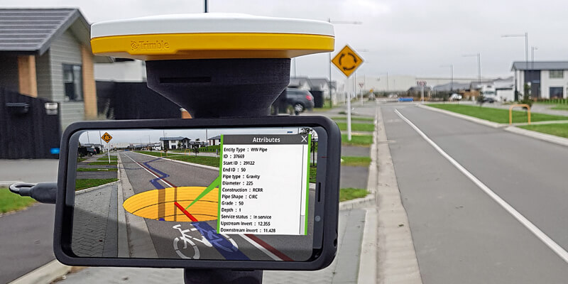
GNSS can supply the positioning and accuracy, but often requires separate hardware and work processes to do so. This issue is solved by Trimble’s SiteVision for Utilities, which combines GNSS positioning with AR visualisation. The system runs on Android smartphones or tablets equipped with a small GNSS antenna, enabling operators to use their own familiar off-the-shelf devices to provide on-site visualisation.
For example, vegetation management and associated cutbacks often raise concerns from people who own homes, land or businesses in the area. With SiteVision, field technicians and foresters can visit the site with the customer and see the actual location of poles as well as the edges of the easements and rights-of-way, which can be visualised in AR as translucent vertical walls in the 3D model.
But there’s more. Using a tool developed specifically for utility AR users, AEP can create and visualise transmission line design blowout models. As a result, design engineers can compute line clearance related to the effects of temperature, wind and sag on overhead lines to show crews and customers what happens to the wires during periods of high winds or maximum sag. It’s possible for AEP crews and customers to clearly see which trees are affected and need to be trimmed or removed. As a result, gaining customer understanding and buy-in on trimming is easier and regulatory compliance is more effective. The approach is helping to optimise both vegetation management and line design, which can decrease risks and possibly prevent outages.
Similarly, AEP uses AR technology as part of its work in corridor planning. After creating georeferenced models for towers and other facilities, staffers can go to the site field and visually compare the design with in-field conditions. The inspection with AR can help AEP engineers detect design clash with existing man-made structures, trees and naturally occurring obstructions and terrain features well before construction begins. Moreover, in areas where underground utilities have been accurately mapped, as-built data can be added to the AR dataset displayed along with the existing and planned structures.
Adding augmented reality to existing workflows
Introducing AR into design and construction processes was a gradual process. It began just over a year ago when the engineering best practices team introduced an early version of AR technology to a group of engineering technicians at an annual training conference. The SiteVision solution provides the unique capability to superimpose 3D models against real-world views to enable accurate visualisation of proposed (or hidden) features, on-site and in real-time. The solution provides 3D GNSS positions accurate to 2cm or better. GNSS correction data is delivered via satellite and positions are determined using precise point positioning techniques built on Trimble’s Catalyst.
The high-accuracy positioning is crucial, as it ensures accurate placement and representation of planned designs against existing conditions in the real world. The mobile device and GNSS antenna are mounted on a lightweight handle that provides one-handed operation for safe and easy portability of AR technology outdoors.
Even in the early stages, our technicians quickly recognised the potential of AR. Before the training was complete, they were proposing new uses for AR and cemented the idea that AEP would be an early adopter of technology.
AEP is now rolling out AR to a wider number of users and applications. In the process, one challenge that has emerged was the creation and management of 3D models for the myriad structures and fixtures the company uses. That effort continues, with AEP working to build a library of models accessible to design and construction teams.
Another challenge was in minimising the impact on design teams by ensuring a smooth connection between the existing field design system, Distribution Design Studio (DDS) from Geospatial Innovations, and the AR solution. Making the connection proved to be straightforward. Once a design is complete in DDS, the designer can use an existing routine to convert it into KML format and place the design into a designated folder in a cloud-based file sharing system. From there, an automated process uses a cloud storage and transfer process to download the model into the SiteVision app on the mobile device.
In addition to checking designs in the field, operators can use the model to collect additional information about existing designs. SiteVision also incorporates an electronic distance measurement tool (EDM), which enables users to accurately measure the distance between design components and distances of designs to existing structures or vegetation. The added data helps ensure regulatory compliance and clearance. Users can also capture the position of objects or terrain features and add the information to the model, which office staff then assess to make any necessary design changes.
The future
Looking forward, there are widespread applications for AR in utilities. One opportunity lies in tracking underground electric assets as well as those of other utilities. As georeferenced datasets of assets expand, the location of buried oil and gas pipelines, water, sewer, and communications infrastructure can be displayed to users in the field. AR may also be used in damage assessment. Features can be captured in their original condition and then compared conditions following an incident that results in damage or displacement.
Augmented and virtual reality continue to move into more arenas within AEP and are moving beyond electric utilities as well. Each application will bring its own opportunities and challenges. But it’s difficult to overstate the potential for the technology to provide important results in increased efficiency, safety and cost management. AR and VR will continue to give our teams a simple, powerful assist in getting their jobs done.
Matt Shellenberger is a staff engineer at American Electric Power (www.aep.com)


