Share
Sören Themann and Stephen Ferretti consider the technology milestones that have changed subsea survey over the past 175 years, while looking towards the next defining breakthrough that could further transform the industry: unmanned surface vehicles
Marine data acquisition process and methodology has changed radically over the last century and more. While navigational safety in coastal waters was perhaps the primary beneficiary of ‘lead and line’ measurements for maritime charts, it was (at the time) the unthinkable notion to lay down the first trans-Atlantic telegraph cable around 1850 that catalysed the need for greater understanding of the seafloor.
The first technology milestone is the 1920 development of echolocation, which would eventually lead to the use of lead and line being replaced by the first echosounders. Commercial sonars based on naval technology used in World War II came along approximately 30 years later, before innovations in stabilisation, modulation and positioning contributed to a major jump in data quality during the 50s.
The first commercial multibeam echosounder systems were introduced in 1977, bringing with them a new approach that would cover a wider swath under the survey vessel for better efficiency while offering higher resolution results. Countless developments over four decades honed and refined multibeam technology practically to its singularity – data quality is as high as it can possibly be now, unless of course there is an unlikely breakthrough in the physics of sound in water waiting around the corner.
This means that innovation has been focused elsewhere. Position reference systems, launched after GPS became ubiquitous, have optimised data accuracy, while new technical features have simplified and streamlined the complexity of multibeam systems. Perhaps the most exciting new development, one that may be seen as the driver for the next step-change, is the application of marine robotics for hydrographic survey.
The modern era of unmanned or autonomous systems for use in seafloor mapping was pioneered in the early 90s with the advent of autonomous underwater vehicles (AUV). Today, survey lines carried out by AUVs are measured in the millions of miles, and innovative variants called ‘gliders’ can even carry out missions without the need for any fuel or large batteries.
New platforms and applications
Unmanned surface vehicles (USV), traditionally lower-cost, more manoeuvrable than AUVs and with the ability to reach surface locations not possible in a survey vessel, are well positioned to move marine surveying forward. While the use of USVs in marine survey is not new, recent innovative applications have furthered the case for them to become the “next big thing”.
An important area of operations that still challenges expert hydrographers is the collection of accurate and dependable seafloor measurements close to shore in the surf zone, between deeper water and the beach. The common solution today is to map from as close to the beach as possible in a manned vessel and then try to fill the gaps in the data from land. It’s essentially best effort, which is far from ideal for the agencies tasked with managing coastal erosion and companies performing the dredging works needed.
Acquiring such data using a manned or larger unmanned vessel depends heavily on local launch and recovery facilities including boat ramps and dock space. If such facilities aren’t available close-by, the operational window will be shortened due to the time needed for a vessel to reach the site. Furthermore, in many cases larger, more expensive vessels with deeper drafts will be needed to ensure transit safety over longer distances.
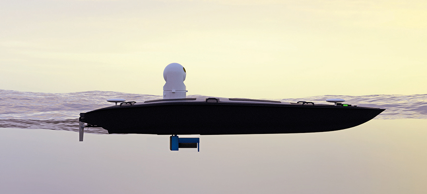
A small, manned craft can be launched from the beach, but this is considered too hazardous in most conditions. That leaves only one sensible option – a USV and relevant hydroacoustic payload with a launch and recovery system (LARS) capable of safe operations in the surf zone. Understanding the challenges, Florida-headquartered Maritime Tactical Systems (MARTAC), a USV manufacturer, set out to build a solution that would simplify and optimise seafloor-mapping in the shallow waters close to the surf zone.
Surveying in such shallow water requires a platform with practically zero draft, along with high manoeuvrability and propulsion power, and the ability to carry the aggregate payload of echosounders, positioning systems and auxiliary equipment needed for precise data acquisition. MARTAC selected its existing 3.6m MANTAS T12 USV for the job, as it was already proven as an effective hydrographic survey platform capable of extending operational survey windows.
Before putting the MANTAS T12 to the test, a brand-new LARS system had to be built from scratch. The result was a dedicated crawler built to accommodate the MANTAS T8 and T12 vehicles. It features four vertical guide bunks that protect from damage and ensure the MANTAS is launched with the correct heading. A 2-lever manual control station is mounted on an articulating arm to provide a safe operating distance. Custom-built slings and pull-string hook-clamp easily hold and detach the MANTAS from the lifting mechanism while a safety pin on a separate pull-string prevents accidental release.
In August 2021, an exercise was conducted in the Surf Zone at Brigantine Beach, New Jersey US with MARTAC’s US partner Telestra Technologies, to test both the crawler and MANTAS T12. An RTK (Real-Time Kinetic) GPS augmented by pitch and roll was used to position a single beam echosounder to measure seabed elevations in the surf zone.
The premise was to demonstrate the reality of autonomous data collection in challenging conditions (using preset lines), to prove the safe and effective beach launch and recovery and the seaworthiness of the T12 when operating in dynamic surf zone conditions. The exercise also verified that the assembled hydrographic system could collect precise data with confidence in its positioning and depth data results.
The testing was a success, allowing MARTAC Systems and its partners to be able to add a completely new and much-requested USV application to the long list of roles possible for the MANTAS T12. The USV combines the high performance of an autonomous and precise USV with the powerful capabilities of modern echosounder sensors to survey bathymetry, inspect assets and detect objects. Its autonomous capabilities come alongside new levels of operational performance that will open the door to new and unique survey approaches as well as filling the gaps in others.
In an additional new concept, already tested using the T12 is swarm survey, MARTAC has successfully demonstrated hydrographic swarms in multiple exercises showing a future where synchronised USVs can survey an area of the seafloor many times faster than a single manned platform. This provides a potential application of the swarm survey approach that leverages the T12’s task endurance and payload flexibility for data acquisition in and around offshore wind farms.
Smaller unmanned vessels can operate in an offshore wind farm much faster and without the associated safety risks of normal survey vessels. As such, rather than mobilising multiple boats with multiple crews and hydrographers, a single manned boat, supported by a swarm of USVs can be dispatched to the job and deliver within hours rather than days. A potential end game to this ‘mother ship concept’, could be multi-use USV ‘janitors’ resident on site, ready to go into action when they are needed.
Sensors and systems
But what about the hydrographic technologies we started out discussing? It’s clear that, despite the last step-change being the introduction of the multibeam echosounder in the 1970s, work never stopped. Autonomous and unmanned systems have not developed in isolation from hydrographic survey technologies. In fact, much of the progress in marine robotics, including USVs, for subsea survey has been enabled by greater integration and more compact variants of high-performance sensors and systems.
It’s in this field that MARTAC and its new European partner Subsea Europe Services hope to make advances after joining forces in a new trans-Atlantic partnership, which will see the latter focusing on the integration of the most powerful hydrographic equipment on MARTAC USVs. Work will focus on creating the world’s first autonomous, turnkey marine survey solution based on the MANTAS T12. The work aims to further simplify the acquisition of marine data to a point where such a solution can be pre-configured and used by customers even with very little marine survey knowledge or experience. And through this, it will be possible to democratise marine data so that practically every organization can access it, without the need for in-house expertise.
New echosounder features tend to be automatic, but the integration of hydrographic and related systems is helping to move things further towards autonomous operation. Subsea Europe Services has already shown how integration between hardware, software and engineering can reduce the complexity of marine surveying with the development of its integrated Hydrographic Survey System (iHSS).
MARTAC USVs are now essential to phase two of the iHSS’ development cycles, where standardised sensors and systems are combined with platforms to become complete survey solutions. There are many scales to measure levels of autonomous operations in industry and the iHSS was conceived to ultimately sit at the top where complete autonomy, without a human in the loop is second nature. The technology is not at that level yet, but based on the performance of the T12 and iHSS, the day will come where one button press is all you need to update your seafloor data.
It’s certainly a real possibility that the history books will record USVs as an important element in the ongoing development of marine data acquisition. But even with their ability to deliver complete coverage and maximise operational efficiency, USV technology alone may not become the next marine survey step change. Bringing marine data acquisition facilities to a much wider customer base using the deep integration of sensors, systems and solutions as the enabler could, however, be the step-change we are looking for. Watch this space, and we’ll know for sure in about 30 years.


