Share
With drone survey and remote working on the rise, GeoConnexion lifts the lid on the latest development from 3DUserNet …. one that pushes the boundaries of online 3D and 2D Survey data viewing, manipulation and collaboration at a price point everyone can afford
When London-based 3DUserNet launched its online platform of the same name in 2017, it heralded something of a revolution in viewing and manipulation of point cloud and 3D model data.
What had hitherto been largely confined to in-house specialists with expensive software and formidable processing power was, for the first time, opened up to a wide audience, not least those in the AEC sectors and where BIM ways of working were driving the need for ever closer collaboration. For the first time, 3D data and projects could be handled and shared via an easy-to-use online service, using any modern device, anywhere.
Everyday tool
For company CEO and co-founder Paul Snudden, the ambition at that time was clear. “We hoped our portal would become an everyday tool not just for the high-level professionals, but for collaboration internally and externally between people across organisations – really harnessing the potential power of point clouds and models”
Four years on, the likes of Arup, BAM Nuttall, Plowman Craven, Port of London Authority, Value Retail, TexoDrone, DroneSurv/Quarry Management, Team UAV and Total Hydro in Australia, to name a few, have taken advantage of the 3DUserNet subscription service to streamline their operations on some of their projects.
In heeding user feedback, those years have seen the portal enhanced with a variety of new and improved features. In 2019, users were given the option to upload and view line drawings in varying formats; integrate them with 3D point cloud data/3D surface models, and use all the portal’s existing measurement and annotation features. Other improvements have included:
- A clip box feature with which to slice-and-dice large projects into more manageable pieces.
- A Check Point Tool with which to validate survey data against known points or control points
- An X-Ray mode with which to add transparency to point clouds and 3D models.
- The ability to toggle between Perspective and Orthographic views
- A DataDrop feature for the more flexible uploading, storage and sharing of files
Adding VISION for a New World of Survey
If these incremental improvements were welcomed, this month sees the debut of a major revamp of the platform following an 18-month development and testing programme.
The move is primarily in response to the dramatic increase in the use of Imagery from drone and mobile mapping surveys, so streaming and tools to work with these surveys is a primary part of the revamp, but it also includes many more additional features.
Now known as 3DUserNetVISION, it claims to be ‘the most comprehensive, and highest quality streaming and work platform for all 3D & 2D Survey Data and Imagery outputs, together with job collaboration features and flexible Modular Licensing.’
It gives Subscribers their own Branded online Portal for creating and sharing survey deliverables quickly and effectively.
The key principle is to enable the upload and viewing online of all the different data types and formats for any survey task; inspection, monitoring, asset management or one-off measurement -- not just separately but, where needed, integrated in a single view. Together with a full suite of measurement tools and sharing options, it means businesses can create more powerful deliverables in much shorter timescales.
There is also an enhanced Data Repository, which can store any project related documentation and be accessed directly or from the 3D View. So all the information for a project is accessible all in one place.
“In this new world of survey it is all about speed of delivery and collaboration on projects, using all the different data now available,” says Snudden, “greater efficiency is the driver of profitability”
Picture perfect
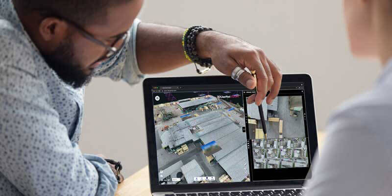
The development team has implemented some radically new image handling techniques to cater for the new needs of the drone and mobile mapping market, and inspection and monitoring in general.
Those gathering UAV LiDAR data and typically dealing with tens of thousands of images will be particularly interested in how 3DUserNetVISION organises them so that any geo-located and oriented image can be previewed fully-aligned to the point cloud, in thumbnail form and zoomed into to explore in full resolution. It can also handle geo-located but non-oriented images
As part of the development, an inspection window alongside – and interacting with - the 3D view is now available in the UI for inspecting and marking-up of selected images, for sharing with the project team. This is complemented by tools to bookmark, filter and select from a gallery of images.
“It adds up to an advanced portal through which users can integrate all their data, 3D and 2D, in the best way to create powerful deliverables that can be easily shared,” says David Mercel, development director at 3DUserNet.
Those gathering 360 Panoramics will see them streamed and precisely aligned to the 3D point cloud with no loss of resolution when zooming in – “something of a ‘first’ for a platform of this type”, says Snudden.
For all types of imagery, to ensure efficient streaming and browsing, the portal loads only the data that is needed for any required field of view. Users can move between different locations just by clicking on the thumbnails or spheres in the scene; change the size of the icons; show or hide images in the scene, and filter them to extract only those that fall within a defined distance.
Needless to say, the full range of distance, area, angular and height measurement tools provided in the original platform are readily to hand in its successor.
Putting it on the map
In another important development, those whose data is geo-referenced with an EPSG code will be able to input that code into 3DUserNetVISION when creating a project. This will invoke a side panel in the UI that correctly displays vector mapping/satellite imagery and Orthophotos of the scene.
This provides an alternative way to navigate the Point Cloud using the Ortho as a reference. The user will be able to zoom into the Ortho up to 2cm resolution and, again, measurements and annotations can be made on the Ortho view.
Adding Meshes for the best visual experience
With their higher level of normal visual fidelity, high resolution Textured Meshes are becoming an increasing feature of deliverables for Survey businesses.
In another first, 3DUserNetVISION, enables streaming of 3D Tile Format meshes of any resolution. These can be integrated with the point cloud, models and line work where required, and on which Images and Panoramics can be located and measurements and annotations made.
Wider appeal
While the current focus of the portal is on serving users in the construction and engineering sectors, Snudden sees its appeal extending more widely, driven by the rapid growth of drone-based and mobile mapping based monitoring and inspection surveys.
Yet this is but part of the story, says Snudden: “Rather than looking at vertical markets, our growth is linked more to the evolving methods of data capture and which are being applied across all sectors, whether on land, at sea or in the air.” As an example, he points to the increasing use of 3D data to satisfy environmental regulations in the maritime sector that cover the inspection of ballast water tanks on vessels.
Modular Licensing and No User Limits
The new capability for Images and Meshes can be purchased as additional modules to a Core VISION subscription. The important thing is that you only buy the capability annual subscription once for all your projects and users.
The innovative UserNet structure means that there is no cap on the number of users for each project and each user doesn’t need a separate licence of any kind.
With this model, any number of users in a specific project or client UserNet group, will have access to the platform, with a number of different User types available – a boon for those whose collaboration needs vary from project to project and from client to client.
After the subscriptions are paid, (which include 3 UserNets of unlimited users, 300Gb storage and 150Gb Download), the only additional costs are additional UserNets, when required, from £350 each, (which come with additional 50Gb Storage and 25Gb download) and any further data top up and image packages
“At the end of the day, it’s all about sharing information quickly and effectively with all the project team and stakeholders in the most appropriate way possible, and it made sense to remove anything that hampers that,” says Mercel.
With the rollout now underway, those with data at the ready can take advantage of a free but time-limited opportunity to put the new platform through its paces by logging on to www.3DUserNet.com


