Share
The globally active Austrian laser scanner manufacturer will show at the virtual RIEGL booth and in the online forums of INTERGEO 2020 DIGITAL which new developments in the field of LiDAR surveying technology can be used to further advance the digitization of the world.
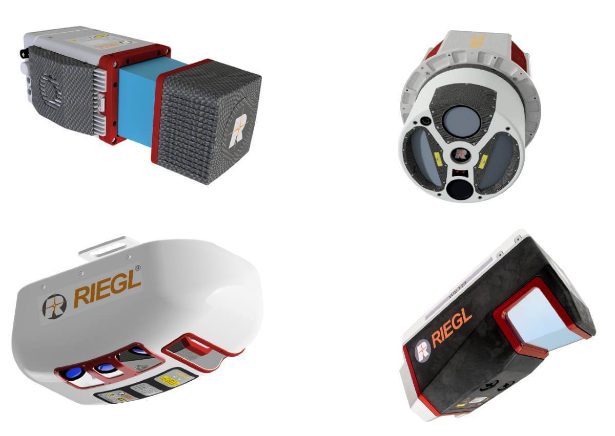
Especially in the field of UAV-based laser scanning (ULS), RIEGL will repeatedly live up to its pioneering role. In 2020, the RIEGL VUX-120 will be presented, a new LiDAR sensor that again sets standards. The sensor, which weighs only 2kg (4.4 lbs) and measures only 225x120x125 mm, features up to 1.8 MHz PRR (Pulse Repetition Rate) and delivers up to 400 scan lines and effective 1.5 million measurements per second on the ground. With its special multi-target capability of up to 15 targets per pulse, the VUX-120 penetrates even dense vegetation, which in this case results in a measurement performance of several million measurements per second. Interfaces for the integration of a high-quality IMU/GNSS system and several cameras are available. With these basic technical data, the scanner presents itself as the ultimate solution for use on fixed-wing UAVs in corridor mapping.
The RIEGL VUX-120 uses an innovative scanning pattern for the optimal detection of even vertical targets, such as high-voltage pylons, house facades or steep mountain slopes. In this so-called NFB (Nadir/Forward/Backward) scanning, the 100° wide field of view is scanned in alternating planes (strictly vertical down, +10° forward oblique, -10° backward oblique).
Additionally, the wide field of view enables users to fly parallel to the asset (i.e. side-looking scanning) as opposed to directly over the target. This ability significantly increases safety for applications such as mapping of power line networks.
In addition, the miniVUX-3UAV will be an extension of the already proven miniVUX series. This compact and lightweight sensor will now have a 300 kHz PRR measuring program in addition to the already existing 100 kHz and 200 kHz measuring programs. This allows up to 300,000 measurements/second at a field of view of 120° and thus a denser point cloud, which enables survey drones to reliably detect even the smallest objects. Like its sister models miniVUX-1UAV and -2UAV, the miniVUX-3UAV can be combined with various IMU/GNSS systems and camera options to optimally match the requirements of the special application. It is also ready to be used with the proven RIEGL Integration Kit 600 - a hardware extension for easy integration with multirotor drones.
RIEGL can also offer innovations in the field of Airborne Laser Scanning (ALS). With the VPX-1 Helicopter Pod, a laser scanning system optimized for use on manned helicopters is now available that offers the ideal performance parameters for applications such as the precise surveying of power line routes or the mapping of urban areas. The new aerodynamically optimized pod is equipped with a RIEGL VUX-240 laser scanner and up to three high-resolution digital cameras as well as an IMU/GNSS unit allows quick system installation and removal using standard hard points and typical camera mounts of helicopters. The effective pulse repetition rate of 1.5 million measurements per second and the optimally adjusted alignment of the cameras (forward/nadir/backward) enables the provision of highly accurate measurement and image data.
With the new VQ-1560II-S RIEGL presents another version of the successful dual channel waveform-processing airborne laser scanning systems for acquisition of extremely dense, highly accurate point clouds.
With increased laser power, operational altitudes of up to 1600 m AGL at a pulse repetition rate of 4 MHz or up to 4000 m AGL at 540 kHz PRR are possible, which results in a significant increase in efficiency when scanning large areas. By fine-tuning the PRR in 12 kHz steps, the acquisition parameters can be set exactly according to the most diverse project requirements.
The unique scan pattern of intersecting scan planes and the various possibilities of parameterization make the device probably the most versatile airborne laser scanner available on the market today. It is perfectly suited for a wide range of applications - from precise corridor mapping to detailed city mapping with minimal shadowing effects in narrow street canyons to large area mapping with highest efficiency of up to 1130 km²/hour at a density of 4 points per square meter.
RIEGL will be presenting these, as well as innovations and further developments in the fields of Terrestrial Laser Scanning (TLS) and Mobile Laser Scanning (MLS), at their virtual exhibition booth at INTERGEO 2020 DIGITAL from 13-15 October 2020.
All visitors of the virtual RIEGL booth can expect a comprehensive program of presentations around the latest product innovations.
The virtual event makes it possible for the first time to offer a program 24 hours around the clock. The individual RIEGL presentations will be given several times in the RIEGL Lecture Rooms (L1 and L2) each day – so please choose the date and time that are most convenient for you!
After each presentation, the RIEGL laser scanning specialists will of course be available for discussions and Q&A!
Secure your free access to the exhibition and register for your visit with the code IG20-riegl.
From Tuesday, 13 October 2020, 9 am CEST, this link will take you directly to the RIEGL booth
There you will find information about the broad RIEGL product portfolio and you will have direct access to the two Lecture Rooms L1 and L2 and also to the Welcome Desk, where they will be happy to help you with any questions and with arranging your meeting appointments.
The RIEGL-team looks forward to meeting you!
Subscribe to our newsletter
Stay updated on the latest technology, innovation product arrivals and exciting offers to your inbox.
Newsletter

