Share
Remote Operation is the keyword of our time, even applying itself to the mining industry.
The VZ-i Series of 3D terrestrial laser scanners are ready to meet the demanding challenges of remote operation.
RIEGL presents three new easy-to-use and intuitive mining apps that will support users in their daily work, especially in critical situations. Based on reliable real-time data, necessary decisions can be made promptly on a sound basis.
RIEGL’s 3D terrestrial laser scanners can smoothly be integrated in any network infrastructure by using LAN, Wi-Fi, and LTE-interfaces, which enables fully remote operation of the scanners. With the installation of customized apps for automatic data acquisition and data processing, the user gets automatic real-time results without any user interaction.
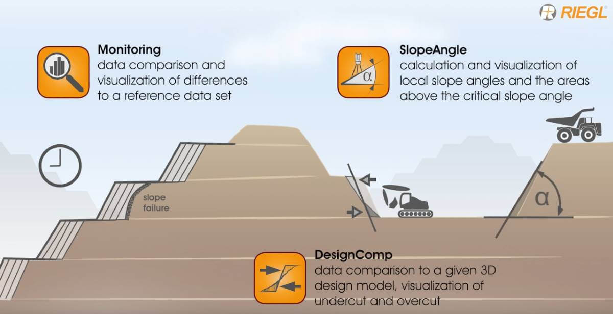
For applications in mining, RIEGL now presents the customized apps
- Slope Angle App
- Design Compare App
- Monitoring App
RIEGL Slope Angle App
Using this app, slope angles are calculated automatically from scan data. Critical slope angles can be highlighted and sent to the user, e.g., the operator of loaders. The real-time information helps them to keep the slope angles of stockpiles and dump areas within the defined limits. They receive the information on a web browser on every device, which is connected to the mine network. No software installation or processing of the data is necessary. Everything is processed automatically within the app on the scanner.
RIEGL Design Compare App
Using this app, overcut and undercut are calculated based on a given design model. While undercut is a waste of money, overcut can involves major safety risks. With the use of this app, the operation of heavy equipment such as digging machines can be optimized to streamline the mining process.
RIEGL Monitoring App
Using this app, change detection can be calculated to a given reference scan. This allows to detect movements of e.g., highwalls long before it is visible to the human eye. The interpretation of the movements through a time series of scans allows the prediction of a possible slope failure. That can truly save lives! It ensures to have enough time to evacuate people and to remove machinery from the endangered areas.
Additionally, RIEGL has further optimized their software packages RiSCAN PRO and RiMINING. The new LIS GeoTec Plugin enables geotechnical analysis of scan data by providing statistical tools within an easy-to-use graphical interface. Besides the calculation of dip-direction and dip-angle of rockfaces, it allows for the analysis of discontinuities by creating pole-plots and colorizing the scan-data by clusters of similar orientation. This gives specialists a better understanding of stability, joints, and faults of the analyzed rockfaces.
Subscribe to our newsletter
Stay updated on the latest technology, innovation product arrivals and exciting offers to your inbox.
Newsletter

