Share
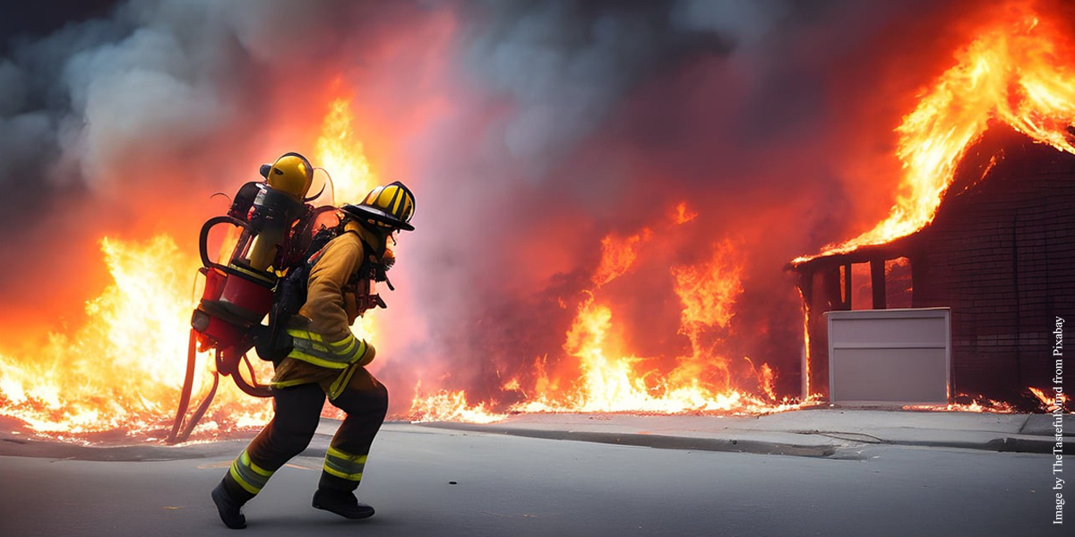
Wildfires present complex socio-economic and ecological challenges, as they devastate vegetation, endanger communities, and cause extensive environmental, wildlife, and human health impacts. Researchers have now unveiled pioneering mapping results that show a significant surge in global Wildland-Urban Interface (WUI) areas over the past 35 years
Wildland–Urban Interface (WUI) areas, which are transition zones between wilderness and human-developed land, are particularly susceptible to wildfires. The risk is heightened due to flammable vegetation and the effects of climate change, such as rising temperatures and frequent heat waves. Consequently, mitigating wildfire risks has become a global priority.
Although WUIs are known to be densely populated by wildfires, there is still a significant knowledge gap regarding their spatial and temporal characteristics, as well as their global wildfire exposure risks. Recently, researchers from the University of Hong Kong, in collaboration with leading interdisciplinary teams from UC Davis, Yale, Utah and Tsinghua, unveiled pioneering mapping results that show a significant surge in global WUIs over the past 35 years (1985–2020).
Published in Nature Sustainability, this research provides reliable, spatially explicit WUI mapping and quantifies WUI—wildfire interaction under climate change. The findings offer essential insights for effective fire management, resilient community development, and global insurance regulations.
The research team has introduced an innovative method for mapping interfaces with crucial human-nature conflicts, using data from Meta for building footprints and data from satellite-derived land cover classification products for wildland vegetation to examine the interaction between houses and nature.
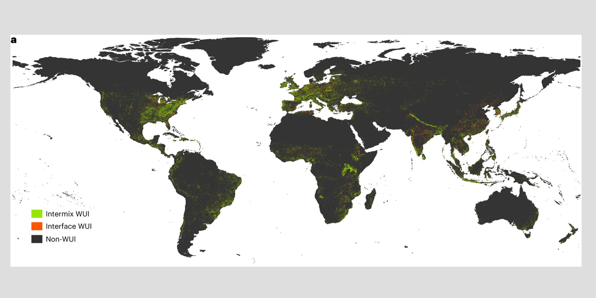
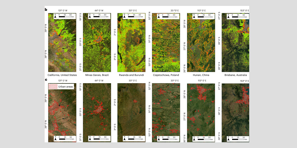
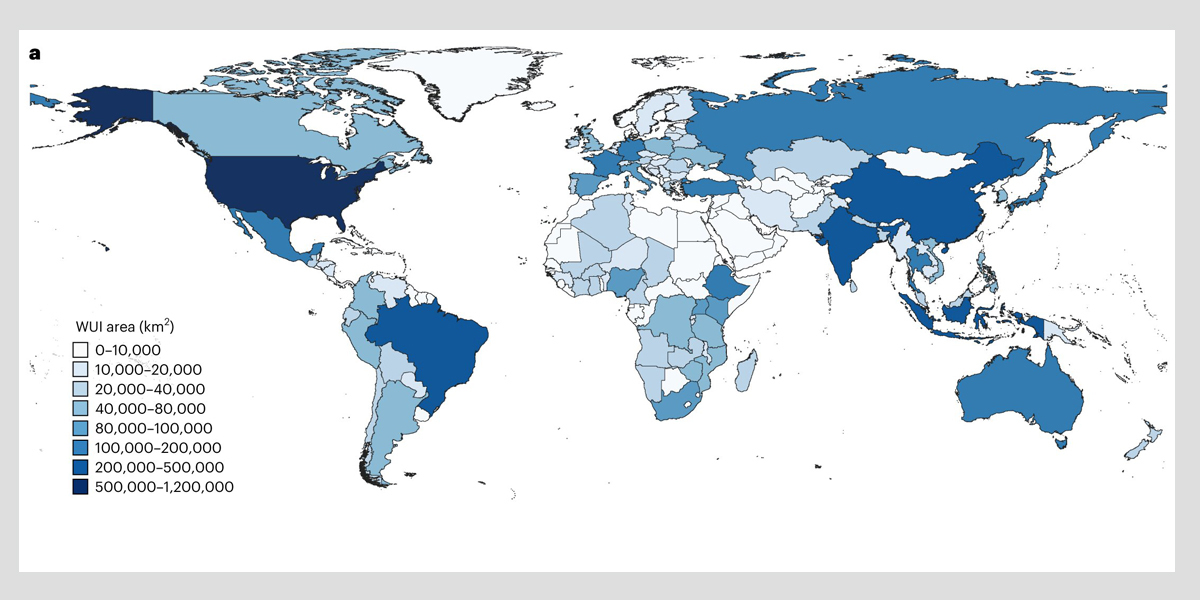
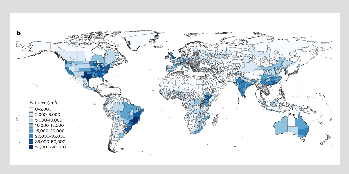
The researchers utilized these detailed and high-resolution data to assess the proximity of buildings to vegetations from 1985 to 2020, revealing the expansive coverage of global WUI areas prone to wildfires, which span a total of 6.62 million square kilometers in 2020.
A time-series analysis from 1985 to 2020 also indicates a substantial 12.56% increase of WUIs over 35 years.
Comparing this information with wildfire history, they estimated potential impacts of wildfires on human settlements within WUIs in various scenarios: directly, with a buffer of 2,400 meters and with a buffer of 4,800 meters from wildfires. Their analysis uncovered that globally, 0.83% of WUIs housing 0.27 million people directly experienced wildfire risks.
Moreover, 7.07% and 12.54% of WUI areas housing 4.47 million and 10.11 million people face potential wildfire threats within a 2,400-meter and 4,800-meter buffer zone, respectively.
"This underscores a significant at-risk demographic even at a distance from the actual wildfire, emphasizing the profound implications for community safety and integrity of infrastructure in the potential far-reaching risks from wildfires," Professor Bin Chen, the principal investigator of this research and Assistant Professor in the Division of Landscape Architecture at HKU explained.
Regionally, the United States, Brazil, China, India, and Australia host most WUI areas, while African countries face heightened wildfire risk despite a comparatively lower WUI extent.
"Our research contributes to an advanced understanding of the spatiotemporal patterns observed in Wildland–Urban Interface (WUI) areas and their associated wildfire risk. This knowledge equips policymakers and stakeholders with the insights to strategically allocate resources and implement tailored measures to protect vulnerable communities," Professor Chen added.
In this study, Professor Chen emphasized the vital differentiation of two WUI distribution subcategories—Interface WUI and Intermix WUI, each reflecting distinct wildfire characteristics and illustrating varying degrees of potential wildfire risk.
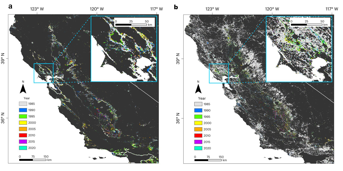
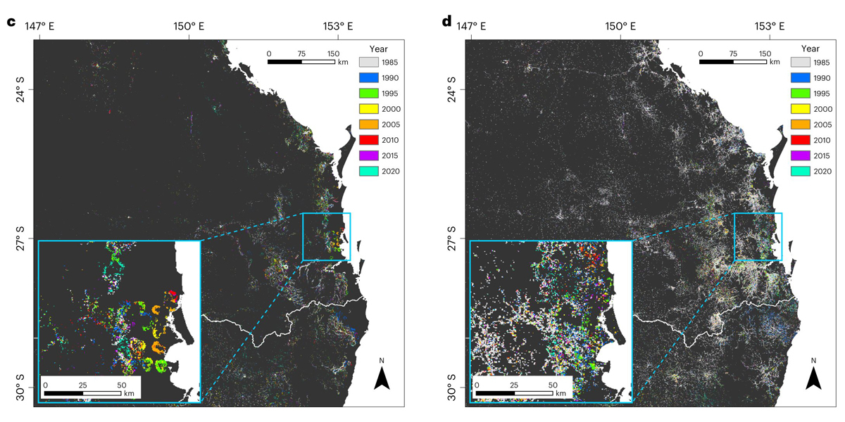
Interface WUI, where housing is near dense wildland vegetation, is spatially delineated on the WUI map, while Intermix WUI is where housing and wilderness closely intermingle. Notably, in areas designated as Intermix WUIs, the risk of wildfires is higher. This distinction in spatial patterns helps us better understand and quantify the comparative risks associated with different types of WUIs.
Professor Chris Webster, Dean of HKU Faculty of Architecture, highlighted the timeliness of the team's findings: "The intensification of global warming, urban sprawl, and the extensive road network expansion at the natural boundaries of cities pose unprecedented challenges for wildfire prevention in the future.
"This research provides a keen insight into the surface changes of global WUI and the mechanisms of fire risk. It timely offers a forward-looking global reference for short, medium, and long-term wildfire risk mitigation under a changing climate, especially for WUI residents, including vulnerable groups."
Professor Peng Gong, chair professor of global sustainability at the Department of Geography and the Department of Earth Sciences, Vice-President (Academic Development) of HKU, stated, "This study aims for an interdisciplinary collaboration to address challenges at the critical WUI areas imposed by human settlement expansion, climate change, and natural hazards.
"Scholars in remote sensing, landscape, earth system modeling, and economic geography have standardized multidimensional data combined with state-of-the-art mapping methods. This collaborative effort has filled the gap in a comprehensive global spatiotemporal distribution of WUIs over the past three decades, solidifying a structural foundation for global wildfire risk assessments.
"The insights gained can guide land-use planning and development decisions, promoting sustainable urban growth while effectively mitigating wildfire risks."
More information: Bin Chen et al, Wildfire risk for global wildland–urban interface areas, Nature Sustainability (2024). DOI: 10.1038/s41893-024-01291-0
Provided by The University of Hong Kong
Subscribe to our newsletter
Stay updated on the latest technology, innovation product arrivals and exciting offers to your inbox.
Newsletter

