Share
Britain's national mapping service has launched new data, including significant enhancements to its National Geographic Database (NGD). These cover elements of Britain’s transport network, as well as footprint geometry and the use of buildings across the nation

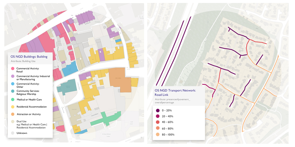
Buildings
As part of this release, the building data being provided has been significantly enhanced. A new building geometry representing the building footprint has been delivered, making it easier than ever before to select and analyse individual properties. This new geometry is also the foundation for multiple enhancements planned to provide more detailed attribution about the building.
These attribute enhancements include providing the building use (e.g., commercial, retail or residential), connectivity to other buildings (for example whether a property is standalone or semi-connected), identifying a primary building within a site (such as a central hospital building with other clinics on site) and also providing the number of addresses which reside within the building - including how many are residential and commercial addresses.
This new geometry and attribute enhancements will have multiple uses ranging from helping emergency services with their preparedness activities as well as response, providing vital data to input into risk models for insurance underwriting, and also enabling local authorities to analyse and investigate the building stock within their area much quicker than ever before.
Transport - Path Coverage Enhancements
OS has increased its coverage of Great Britain’s Path network, now capturing data for the whole of England, Scotland and Wales, whereas previously only urban areas were captured. This work has resulted in over 10 million new path features which equates to an increase of almost 35%.
These enhancements allow further analysis to be undertaken on how pedestrians complete routes using both the road and path network. This analysis supports Active Travel policies, improvements to public health and projects to encourage walking. All are aiming to reduce congestion, promote access to green spaces and improve routing analysis.
Transport – Pavement Presence Information
An additional significant update means that pavement width and their presence along roads are now available as additional attributions to the road network for the first time. This will benefit analysis relating to those using mobility scooters, wheelchairs or pushchairs. This also further enables councils to support key citizen services, such as maintaining and understanding their pavement assets.
Transport – Rail Network
Completing the transport portfolio for this release is the creation of a new generalised Rail Network for Great Britain.
This network is the first of its kind to be released by Ordnance Survey and will allow customers to understand how well-connected areas are in relation to rail, understanding the transportation of goods, meeting their local transport needs, and also improve situational awareness for emergency services when attending emergencies on our rail network.
The network also includes new attribution such as whether the rail network is used for freight, passengers or both and whether the rails are part of the mainline.
All the new data enhancements mentioned above have been released in the OS NGD which is available to public sector customers and OS Partners through the OS Data Hub.
Customers can choose to access OS NGD data via OS Select+Build which allows users to download only the data they need, or via the OS NGD APIs. Customers can also access technical support and information on the OS NGD in the OS NGD Documentation Platform which includes step-by-step instructions on functionality and getting the best out of our new access methods.
This latest data release is yet another demonstration of the value of OS as the country’s national mapping service, providing incredibly detailed and accurate layers of geospatial data. This new information will enable customers to deliver improved public and commercial services and support the promotion of healthy, sustainable and connected communities.
Ordnance Survey works in strong collaboration with its customers, identifying how accurate, trusted location data can help tackle the challenges they are facing, both at a national and local level. I am looking forward to seeing how these datasets will ultimately help people see a better place.
In commenting on the release John Kimmance, Managing Director of OS National Mapping Services, said: “It is yet another demonstration of the value of OS as the country’s national mapping service, providing incredibly detailed and accurate layers of geospatial data. This new information will enable our customers to deliver improved public and commercial services and support the promotion of healthy, sustainable and connected communities.
“We work in strong collaboration with our customers, identifying how accurate, trusted location data can help tackle the challenges they are facing, both at a national and local level. I am looking forward to seeing how these datasets will ultimately help people see a better place.”
The new data hits a major delivery commitment under the Public Sector Geospatial Agreement (PSGA), which provides public sector organisations with trusted location data for free.
For more information about the OS Data Hub, visit OS Data Hub | Free Maps & API Data for Developers
Subscribe to our newsletter
Stay updated on the latest technology, innovation product arrivals and exciting offers to your inbox.
Newsletter

