Share
To advance natural hydrogen exploration, STRYDE’s low-cost, compact, autonomous seismic nodes were recently used to acquire dense, three-component (3C) passive seismic data across the Pyrenees foothills.
By Amine Ourabah, STRYDE
Natural hydrogen (H₂) has gained increasing attention as a geologically sourced, low-carbon energy carrier with the potential to complement industrial hydrogen production. Generated through processes such as serpentinization, radiolysis and deep mantle degassing, natural hydrogen occurs both as diffuse surface emissions and in localised subsurface accumulations. While its existence has long been documented, systematic exploration remains limited, and robust geophysical investigations are required to delineate reservoirs and migration pathways with the precision needed for energy applications.
Despite its promise as a clean energy source, natural hydrogen remains poorly understood due to limited exploration data, particularly high-resolution geophysical datasets which are critical for subsurface modelling.
To advance natural hydrogen exploration, STRYDE’s low-cost, compact, autonomous seismic nodes were recently used to acquire dense, three-component (3C) passive seismic data across the Pyrenees foothills.
The mountain range, which separates the Iberian Peninsula from the rest of Europe, stretches more than 430km between Spain and France and rises higher than 3,400m in elevation.
This study demonstrates how dense nodal arrays significantly improve microseismic event detection and subsurface imaging, offering a cost-effective pathway to high-resolution geological models in regions of potential natural hydrogen accumulation.
The survey area
Natural hydrogen emanations have been documented along the North Pyrenean Frontal Thrust and related deep-reaching faults, suggesting potential pathways for H₂ migration from the mantle or deep crust (Lefeuvre et al., 2021). The Pyrenees foothills present an ideal setting for detailed investigation due to their combination of geological favourability and active microseismicity. Evidence of serpentinization in ultramafic rocks indicates ongoing H₂ generation, while north-dipping thrust faults and fractured Hercynian basement structures provide potential migration corridors to the surface.
The region’s relatively sparse permanent seismological coverage allows dense temporary seismic node arrays to substantially improve microseismic detection and subsurface imaging. Furthermore, the area’s accessibility and terrain enable the deployment of large numbers of lightweight autonomous nodes, which can be arranged in dense 3D grids to capture high-resolution seismic data. Together, these factors make the Pyrenees foothills a natural laboratory for both advancing geophysical techniques and improving understanding of natural hydrogen generation, transport and surface seepage.
Experimental setup
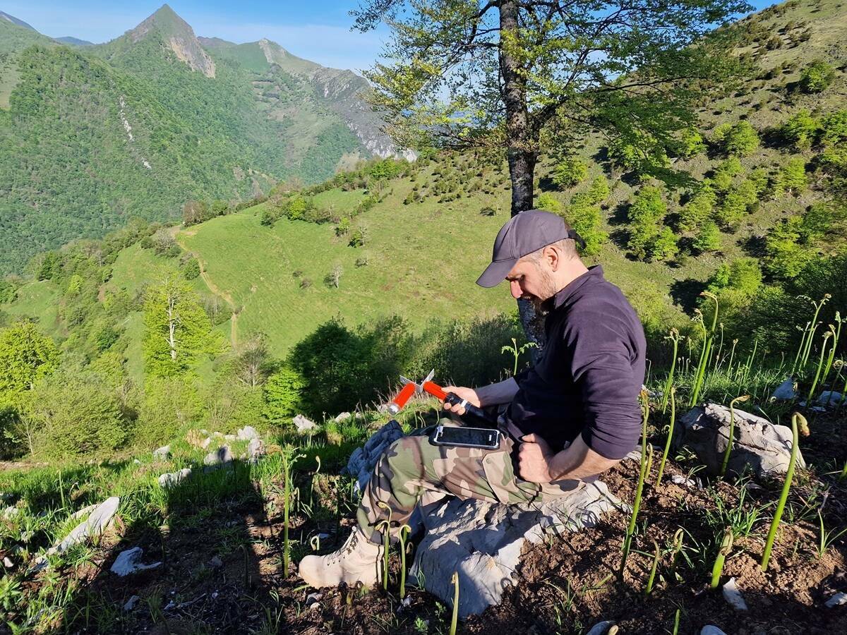
To investigate microseismicity and potential hydrogen migration pathways, 900 STRYDE autonomous seismic nodes were deployed across a 10km × 10km area near Arette, France.
Each node, weighing just 150g and measuring 13 × 4cm, is equipped with a piezoelectric accelerometer and a Global Navigation Satellite System (GNSS) for timing and positioning, enabling continuous recording at 1-2 millisecond intervals for up to 54 days. While each unit is a single-sensor accelerometer, STRYDE nodes can be arranged in a three-component (3C) configuration, combining three horizontal sensors with one vertical component, to effectively capture both P- and S-wave signals comparable to conventional 3C geophones.
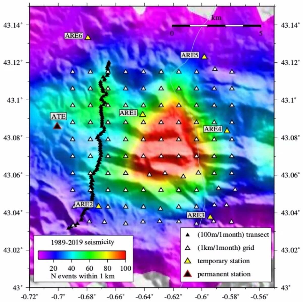
The nodes were deployed in a 1km × 1km grid forming a dense 3D array over the main survey area, with an additional 2D line of 100 3C stations along a road to the east for enhanced coverage (Figure 1). Deployment was completed by foot, in five days by a 10-person team working in pairs, demonstrating the logistical advantages of STRYDE nodes for rapid, large-scale deployment in challenging foothill terrain. Continuous recording over a one month provided a robust dataset for high-resolution microseismic monitoring and subsequent tomographic imaging, highlighting the nodes’ suitability for deep geological imaging essential for natural hydrogen exploration.
Data processing and analysis
Following retrieval, the continuous one-month dataset from all nodes underwent rigorous quality control. Microseismic events were automatically detected using a deep neural network algorithm called PhaseNet, and relative relocation was performed using the double-difference earthquake location computer program HypoDD.
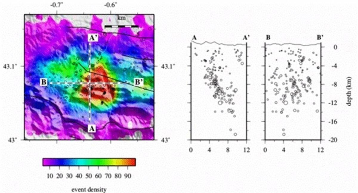
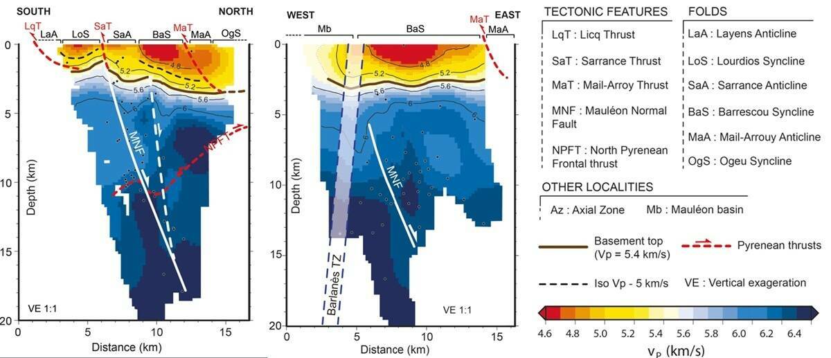
A total of 550 microseismic events were identified, roughly half of them were located directly beneath the dense nodal grid, with magnitudes ranging from -2.1 to 2.3. Plotting these events in depth shows a clear delineation of the Mauleon Normal Fault (MNF) , which is consistent with long-term seismicity recorded by permanent networks in the Chaînons Béarnais region (Figure 2).
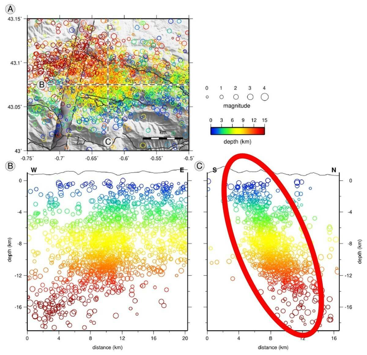
Local earthquake tomography (LET) was conducted using these events to image the upper crust beneath the temporary array. Only events with both P- and S-wave picks were retained, resulting in 209 earthquakes and 14,673 picks for inversion. On average, over 70 stations contributed picks for each event, ensuring dense ray coverage for robust tomographic modeling. The inversion simultaneously resolved P- and S-wave velocity structures and relocated the earthquakes within a 20km × 20km × 25km volume, sampled at 200m intervals. After ten iterations, RMS arrival time errors decreased from 0.116 s to 0.076 s for P-waves and from 0.098 s to 0.047 s for S-waves, demonstrating substantial improvement in model accuracy.
Results
The dense array allowed detection of microseismic events down to approximately -1 magnitude, well below the detection threshold of permanent networks, generating a rich dataset of P- and S-wave picks for LET. This resulted in a high-resolution crustal model with a resolution approaching that of active-source surveys but at a fraction of the cost.
Key observations include:
• Two distinct velocity domains separated by a ~5.6 km/s P-wave iso-velocity contour, delineating the sedimentary cover (<5.6 km/s) from the Hercynian basement (6.0–6.4 km/s).
• A prominent north-dipping fault extending to ~16km depth, aligned with deep seismicity, which may act as a migration pathway for natural hydrogen.
• Folds and thrusts in the sedimentary cover consistent with surface geology, and a deeply fractured basement, both of which may influence H₂ transport to the surface.
No definitive velocity anomalies indicative of serpentinized mantle were observed within the shallow crust, although nearly complete serpentinization could produce physical properties similar to upper crustal rocks, leaving this hypothesis open.
Implications for H₂ exploration
The results of this study demonstrate that dense deployments of STRYDE autonomous nodes in a 3C configuration can provide high-resolution microseismic monitoring and tomographic imaging of deep geological structures, directly supporting natural hydrogen exploration. The ability to detect microseismic events down to magnitude ~-1, well below the detection threshold of permanent seismic networks, allowed precise mapping of faults and fractures that may serve as conduits for H₂ migration from deep-generation zones to surface seepages.
From an exploration perspective, the study highlights several key advantages of this approach:
• Scalability and affordability: The lightweight, low-cost, compact design of STRYDE nodes enabled rapid deployment of hundreds of stations by foot, over challenging foothill terrain, making high-density surveys feasible.
• Enhanced resolution: Dense nodal coverage significantly improves event detection and depth determination, yielding tomographic models with resolutions approaching active-source surveys but at a fraction of the cost.
• Actionable insights: Mapping faults and structural pathways provides critical information for interpreting surface hydrogen seepages and targeting further exploration or drilling campaigns.
Overall, the experiment illustrates how advanced seismic monitoring with dense autonomous node arrays can transform natural hydrogen exploration.
By enabling precise characterisation of subsurface structures and potential migration pathways, this methodology provides both a practical and cost-effective tool for assessing the geological controls on H₂ accumulation and guiding future exploration strategies in the Pyrenees and other geologically favourable regions.
About STRYDE
STRYDE's onshore nodal seismic imaging experts empower high-density land seismic acquisition across the globe with its cutting-edge seismic acquisition solutions and technology. STRYDE has been deployed on over 300 seismic surveys in over 60 counties, supporting oil and gas, geothermal, mining, research and CCUS projects with unmatched efficiency and data quality.
Subscribe to our newsletter
Stay updated on the latest technology, innovation product arrivals and exciting offers to your inbox.
Newsletter

