Share
Briana Brown explores how artificial intelligence and machine learning are changing the geospatial landscape, and how organisations are adopting GeoAI into their workflows.

In recent years, artificial intelligence (AI) has touched every industry in some way, and geospatial is no exception. GeoAI has quickly become a prominent discipline in the GIS and geomatics industries as professionals adopt machine learning-based tools into workflows ranging from data creation to analysis and beyond.
Despite this increase in adoption, a fair degree of skepticism exists within the geospatial community about the real value of AI. As is the case in most industries, some fear the rise of automated solutions will alter the job market. The learning curve for GeoAI applications has also left many professionals wary of implementing them, and the ever-growing selection of available AI-based tools can make it hard to choose where to start. Perhaps the most significant barrier to GeoAI adoption is concern about the reliability of automated data production or analytics results, as the quality of AI solutions can vary greatly.
While there is some merit to these common objections to GeoAI, the reality is that AI and machine learning are shaping the future of the geospatial industry. As these barriers are overcome and high-quality AI-powered solutions are identified, learned, and applied, geospatial professionals are unlocking new levels of efficiency and insights that directly translate to not only increased innovation but also more career opportunities.
Revolutionising data creation
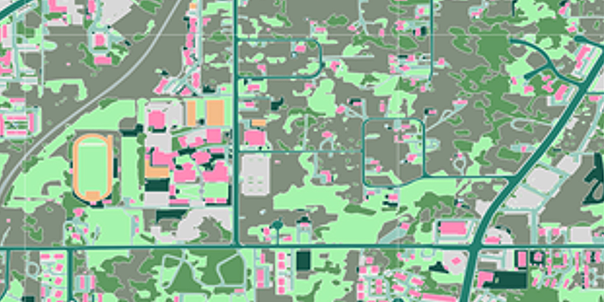
One of the greatest impacts of GeoAI is enhanced efficiency of geospatial data creation. Databases that used to take years to build can now be produced in days or weeks, even at continental scales. This increase in speed and scalability also enables more frequent data updates to keep pace with a dynamically changing world, reducing the likelihood that data and the analytics performed with it will become stale and inaccurate.
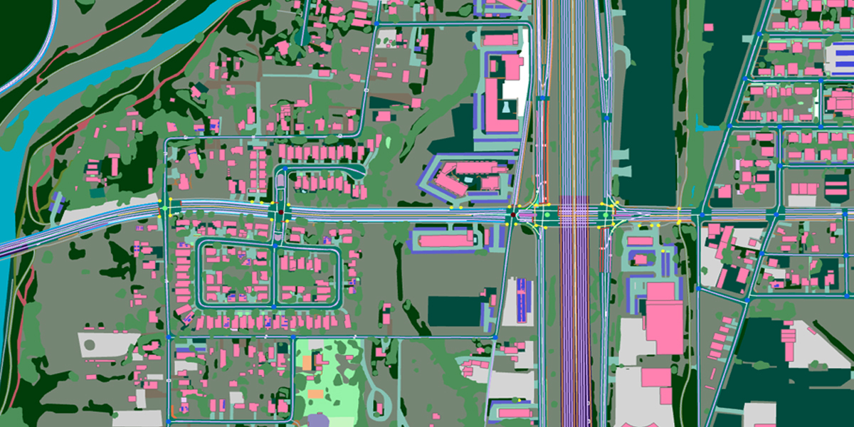
Efficient data creation and maintenance are top priorities for many organisations, including regional planning offices responsible for developing and maintaining infrastructure across large areas. Pima Association of Governments (PAG), the metropolitan planning organisation for the greater Tucson region in Arizona, recently leveraged Ecopia’s AI-based mapping systems to produce 61 planimetric 2D and 3D feature layers across more than 3,646 square kilometers in just a few weeks. Totaling more than 5 million individual features, such as crosswalks, bike lanes, impervious surfaces, and tree canopy, this dataset has refreshed PAG’s regional database with updated insights to inform planning initiatives in active transportation planning, irrigation management, and public safety.
Another benefit GeoAI brings to data creation and maintenance is standardisation. Whether interpreting imagery, digitising features, or assigning attributes, humans will always have slightly different methodologies stemming from individual training and experience. In contrast, machine learning algorithms are trained to produce standardised datasets with identical schemas and specifications, resulting in a uniform representation of features across geographies to streamline analytics.
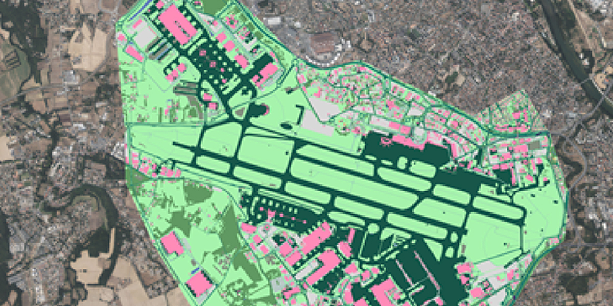
Having a standardised dataset of global operation sites is critical for organisations with large footprints, such as the Airbus Facility Management and Real Estate (FMRE) department. Before turning to AI, varying levels of geospatial maturity across Airbus’s global divisions made it difficult to produce a standardised source of truth for FMRE to leverage in resource allocation and decision-making. Using 15-centimeter satellite imagery from Pléiades Neo, Ecopia’s mapping engine extracted 13 data layers for 72 facilities and their surrounding areas, providing insights into land use change for site development and sustainability management across diverse locations.
Ensuring quality
Standardisation across large datasets is not the only quality enhancement made possible by AI. While automation formerly required geospatial professionals to sacrifice data quality for speed and scale, recent breakthroughs in GeoAI have enabled efficient data creation with human-level precision. Organisations no longer need to choose - they can have it all.
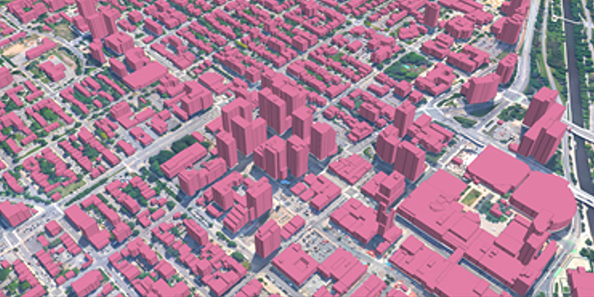
These technical breakthroughs have enabled data providers to pre-build datasets that were once only obtainable on a custom basis. Earlier this year, Ecopia and Nearmap partnered to produce off-the-shelf 2D and 3D vector data across the 400 largest American cities while maintaining at least 95% geometric accuracy. This unprecedented dataset was created in just a few weeks and includes highly detailed land cover classifications such as buildings, pavement, grass, tree canopy, sidewalks, and intersections. Similar data was produced by Ecopia across 40 Canadian cities and is already in use by the Canadian Federal Government for various sustainability initiatives.
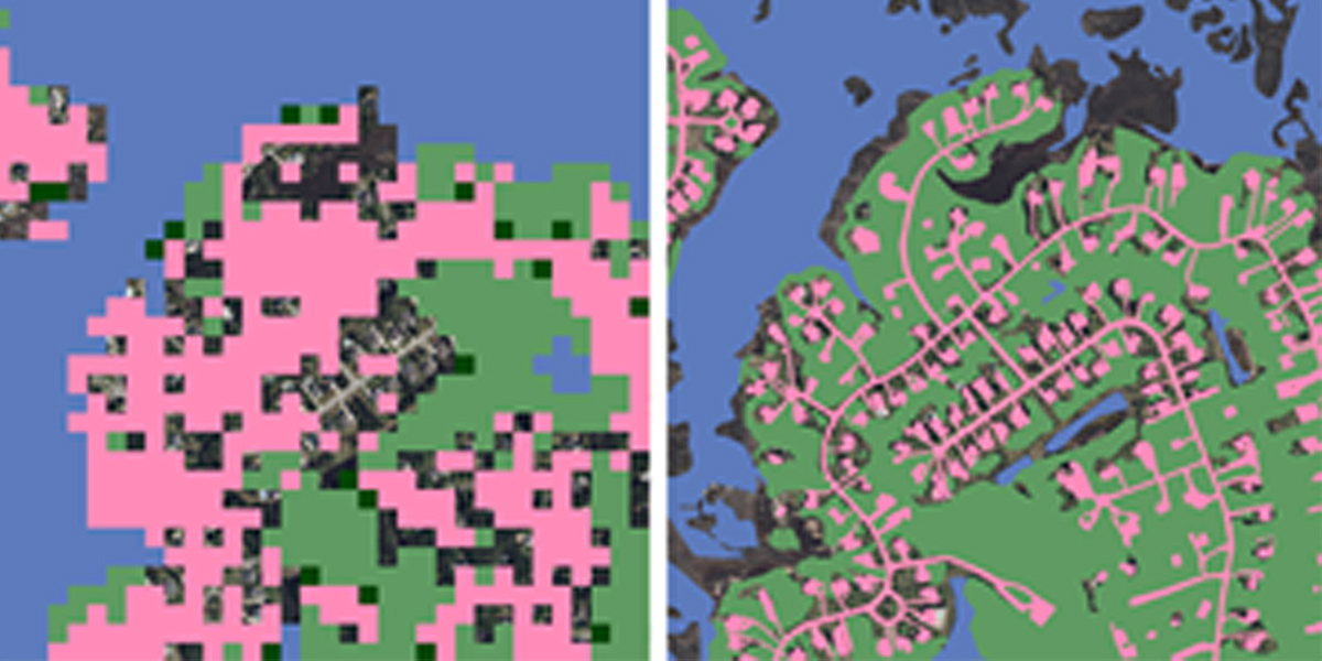
The US Federal Government has also been leveraging GeoAI to enhance data quality. A widely-used open dataset, the National Oceanic and Atmospheric Administration (NOAA)’s Coastal Change and Analysis Program (C-CAP) raster data has traditionally been produced at a 30-meter resolution. Coastal communities have long searched for higher-resolution data to provide more granular insights into land use change, but until recently, technical constraints have made such a dataset cost-prohibitive for most organisations.
Advancements in AI-based feature extraction have enabled NOAA to partner with Ecopia and increase the resolution of the open C-CAP dataset by 900x to 1-meter. The updated C-CAP data delivers a high-quality, uniform representation of US coastal areas, including historically underrepresented Alaskan communities for the first time.
Augmenting analysis
Analytics results are only as reliable as the data used to produce them. Comprehensive, accurate, and up-to-date data is the cornerstone of high-quality geospatial analysis. GeoAI’s impact on data creation and maintenance provides better inputs for analytics, leading to deeper, more precise outputs.
Accurate geospatial analysis is critical in many industries, but especially for government agencies assessing natural hazard risk, developing mitigation strategies, and responding to hazard events. More than 30% of the State of California is considered a Fire Hazard Severity Zone (FHSZ), an area totaling over 32 million acres. To enable the California Department of Forestry and Fire Protection with the insights needed to manage wildfire risk, Ecopia’s AI-powered systems efficiently analysed land cover across all of California’s FHSZs, appending building footprints with important vulnerability attribution such as distance to nearby water bodies, structures, and trees.
AI-based analysis tools are changing the way geospatial professionals perform day-to-day functions. Processes that used to take days, weeks, or even months of manual effort can now be performed efficiently, freeing up time and resources for taking action on insights and enabling organisations to perform even more complex workflows.
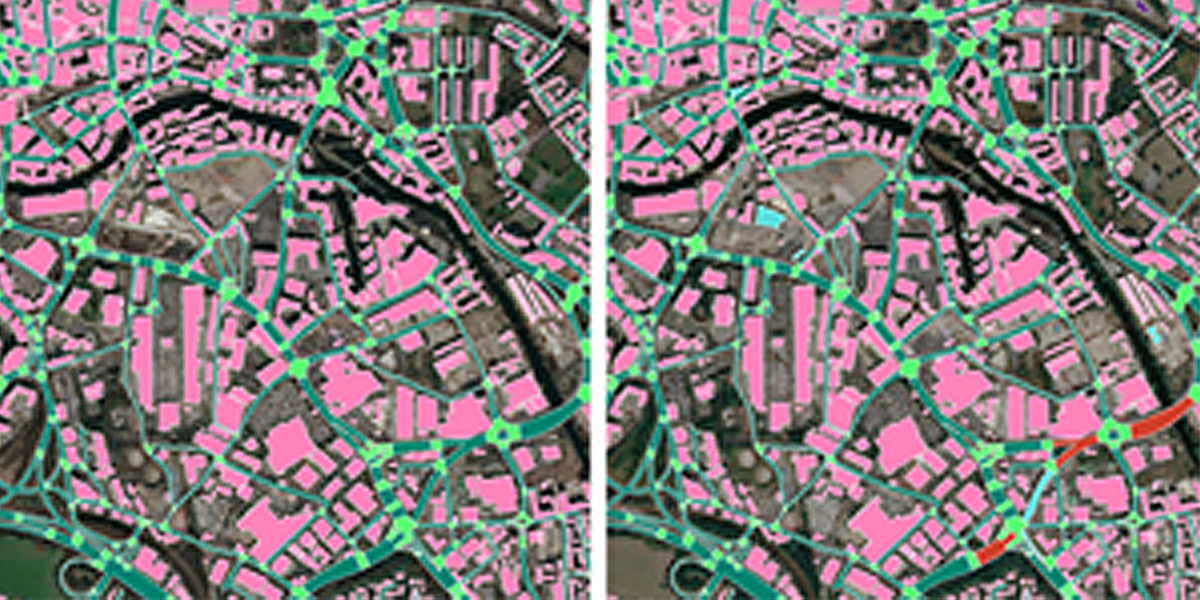
Change detection used to be a highly manual process involving tedious comparison of datasets, particularly across large or dense areas. As the leading railway owner in Great Britain, Network Rail is responsible for 20,000+ miles of track and 30,000+ bridges, tunnels, and viaducts across England, Scotland, and Wales.
Understanding how land use change impacts this vast network is essential for ensuring the safety and sustainability of the infrastructure. Thanks to a GeoAI workflow developed by Ecopia, Airbus, and the European Space Agency, Network Rail can now identify where land use change has occurred in proximity to their assets, informing decision-making and increasing operational efficiency.
The future of geospatial
As with any new technology, it will take some time for the geospatial industry to adapt to the widespread availability of AI. The ability to efficiently produce and update standardised, high-quality data is bringing the industry one step closer to the elusive digital twin, enabling professionals to perform deeper analytics on more detailed, up-to-date information. Rather than eliminating jobs, GeoAI is instead creating opportunities for geospatial professionals to specialise in new workflows, scale their own day-to-day activities, and ultimately drive industry-wide innovation.
Briana Brown is Senior Director of Product Management & Marketing at Ecopia AI, a business headquartered in Toronto, Canada, that specialises in extracting insight from geospatial big data
Subscribe to our newsletter
Stay updated on the latest technology, innovation product arrivals and exciting offers to your inbox.
Newsletter

