Share
Whether caused by nature or human activity, the on-going disasters in our continent highlight the necessity for innovative tools and solutions for resilient risk management and response. The objective is to safeguard lives and protect properties.

With end-users always at the centre of its action, the EU Space Programme continues to evolve, offering services that contribute to the safety and well-being of European citizens.
One such service is the upcoming Galileo Emergency Warning Satellite Service (EWSS), currently under development and testing by the Directorate General for Defence Industry and Space, together with the EU Agency for the Space Programme (EUSPA).
So, what exactly is the Galileo EWSS?
EWSS is an upcoming service of the Galileo constellation, which will be disseminating alert messages directly to the population of areas threatened by a looming natural or manmade disaster. More specifically, the Galileo satellites will be transmitting to smartphones, or to any other navigation devices able to receive Galileo signals (through a chipset), information related to the hazard (such as type of hazard, its severity, time of onset and expected duration, the targeted area) and instructions to follow depending on the area the user is located at. The alert content will be generated by national authorities and transmitted to Galileo for broadcast.
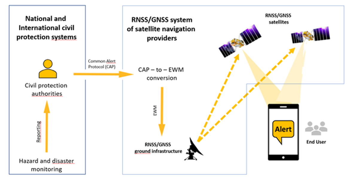
An overview of the Emergency Warning Satellite Services is illustrated above. The service concept includes the following top-level functions:
1. Generate alert: The authorised civil protection authority generates a standard alert message using the Common Alerting Protocol (CAP) format, indicating at least country, issuing civil protection authority, event type and affected area. Other information can be coded to precise the situation (day and time of the onset of the emergency, expected duration, severity, etc).
2. Request satellite broadcast: The authorised civil protection authority sends the message in CAP format for approval to the national or international Emergency Centre who operates the interface of the satellite navigation provider and requests a satellite broadcast of an alert over the affected geographical area.
3. Coding of the alert information: the satellite navigation system encodes the request from the authority into a satellite message (the Emergency Warning Message, or EWM), using the CAMF as format. The geometry of the affected area is converted into a target area in the form of an ellipse.
The real added value of EWSS
This service comes on top of existing alert systems but, as EWSS Manager at the European Commission, Eric Guyader explains, “for reaching the highest number of people in case of danger, the more alert systems the better. And this new service offers an important advantage: it remains available also when other alert systems like mobile networks are congested, disrupted or even destroyed”.
EUSPA Galileo exploitation programme Manager, Guerric Pont confirms, “we continue to broaden the link between users and space, where EWSS will ensure the distribution of alert messages and guidance to safeguard populations, on top of best-of-class navigation data.”
This is particularly useful for people who live in remote and rural regions of Europe with poor or no mobile signal at all. It can also be proved lifesaving when traditional terrestrial alert systems are unavailable due to high traffic, or damage as is regularly the case with earthquakes, floods or fires for example.
Preparing for the service declaration in 2025
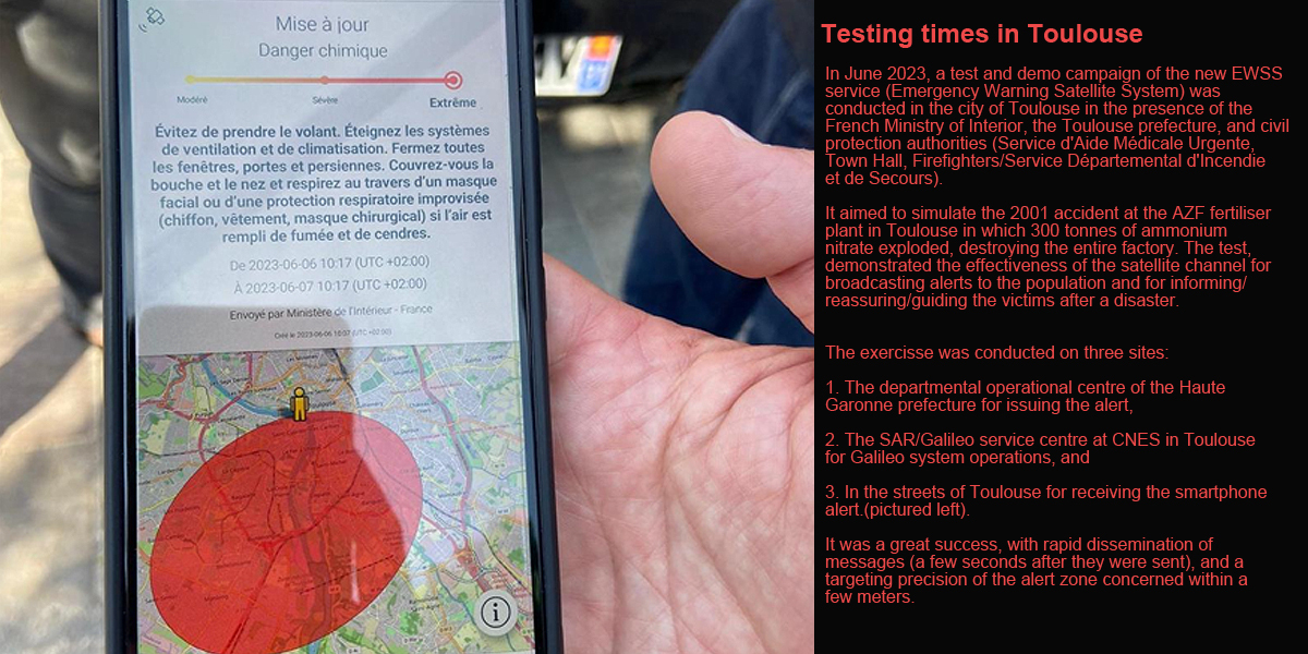
While the service is expected to become operational in 2025, it has already been successfully tested in different sites across the Union. According to the latest tests carried out with several national civil protection agencies, the alert message can be transmitted and received by every user located in the danger area, in less than 60 seconds.
Once operational, it will be offered free of charge to national civil protection authorities across the EU27. It will be up to the EU Member States to decide whether they activate it to disseminate their alerts via the Galileo satellites in space.
Together with the Copernicus Emergency Management Service, EWSS will become a strategic asset to support the policies of the European Union and its Member States in the field of disaster management.
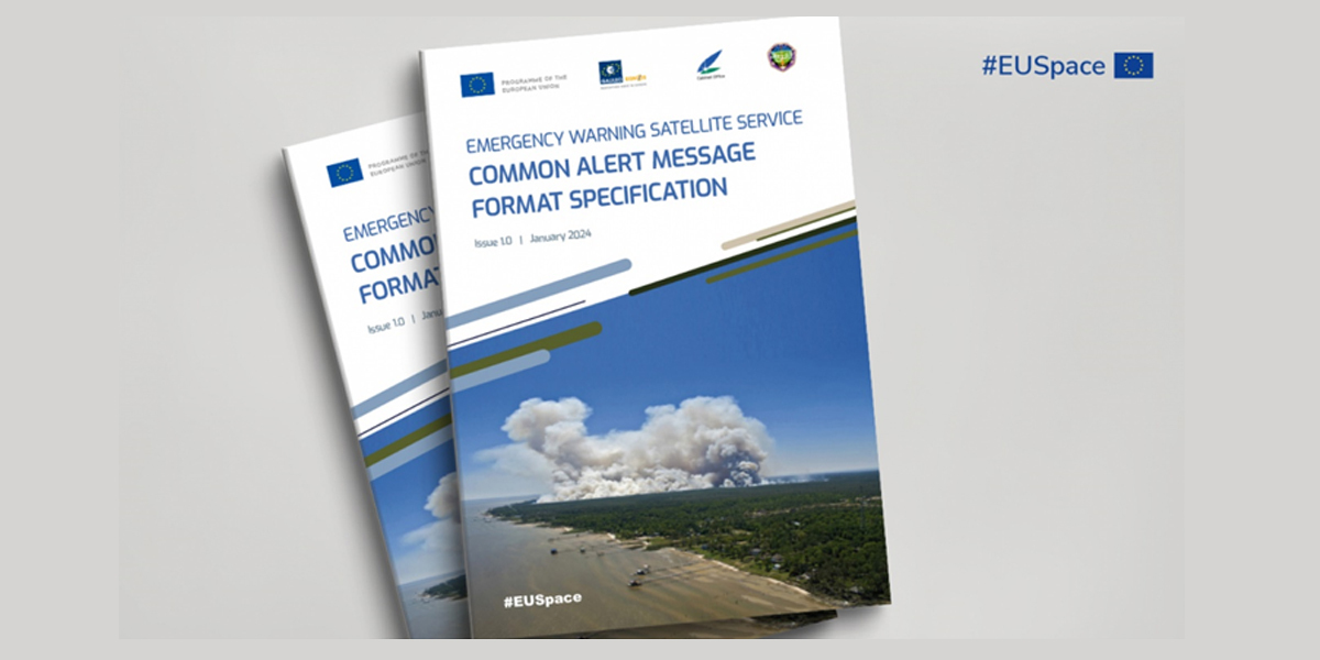
Ahead of the declaration in 2025, the European Commission together with the EU Agency for the Space Programme has published the Common Alert Message Format Specifications document (pictured above)
The technical document contains important information regarding the format of the alert message, to be used for encoding (resp. decoding) the alert information into (resp. from) the Galileo signals.
The document is useful for EU MS to start implementing EWSS in their national alert systems, for receiver manufacturers to introduce the necessary functionalities in navigation devices, and for any satellite navigation systems willing to broadcast alert messages encapsulated in their satellite navigation signals.
For more information and technical details, click here.
Story Source: EUSPA
Subscribe to our newsletter
Stay updated on the latest technology, innovation product arrivals and exciting offers to your inbox.
Newsletter

