Share
In an era of accelerating climate crisis, accounting for all aspects of Earth's carbon cycle is a crucial task. Trees and forests are limited but important instruments among a suite of mitigation options. Marie E. Antoine and Stephen C. Sillett look at how remote sensing can help improve our mapping and understanding of their role
Ecosystem services provided by healthy forests extend far beyond carbon storage capacity. Remaining primary (old-growth) forests are irreplaceably valuable both as carbon storehouses and biological refugia. Forests' ability to regrow after disturbances enables them to regain ecological significance over time.
Understanding the role of forests requires accurate quantification of biomass, approximately half of which is carbon. Technological advances and the urgency of the problem have motivated international efforts toward biomass mapping.
Airborne and spaceborne laser scanning hold great promise, and remote sensing is tempting to rely upon given its efficiency in covering large areas.
However, these endeavors are of questionable value until their estimates are validated by direct measurements. A new article published in Forest Ecology and Management embraces this challenge for the world's tallest forests.
The tallest trees create the highest-biomass forests, but they're difficult to measure properly. Our team specializes in quantifying exemplary trees via climbing, crown mapping, and trunk coring.
Which measurements are best for estimating tree biomass? Diameter at breast height is a familiar metric but a poor predictor for tall and large trees.
Terrestrial laser scanning now allows trunk volumes to be readily quantified from the ground. Combining that with measurements of crown size and total height yields precise tree-level estimates capable of calibrating remote sensing of forest biomass. Consider forests dominated by Sequoia sempervirens (hereafter, redwood) as a case study.
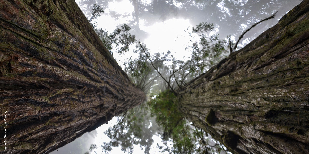
Primary redwood forests are of special interest as the tallest and heaviest terrestrial vegetation. These forests can store more than 2,000 metric tons per hectare of aboveground carbon. Fungicide-enriched heartwood and thick bark make redwoods extremely decay- and fire-resistant, so individual trees can live beyond 2,000 years.
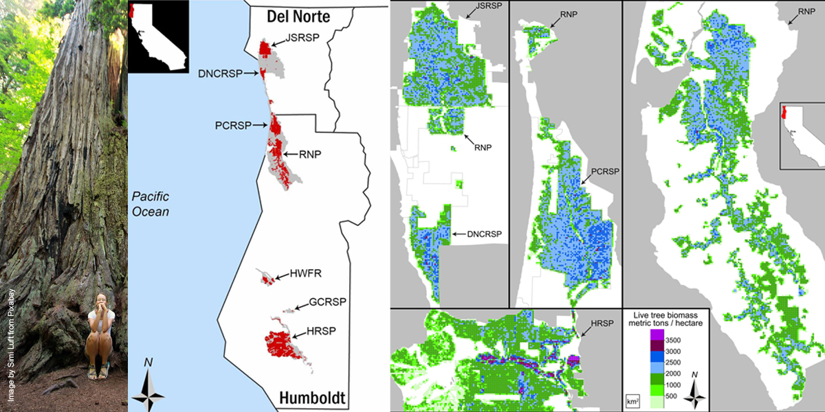
More than 95% of primary redwood forests were logged, and 75% of remaining stands occur in seven state and national parks of Humboldt and Del Norte Counties, California. What can remote sensing tell us about these exceptional forests, and how does that relate to reality on the ground?
Thanks to the Global Ecosystem Dynamics Investigation (GEDI) aboard the International Space Station, a laser scanning dataset is available with maps of canopy height and predicted aboveground biomass for forests around the world.
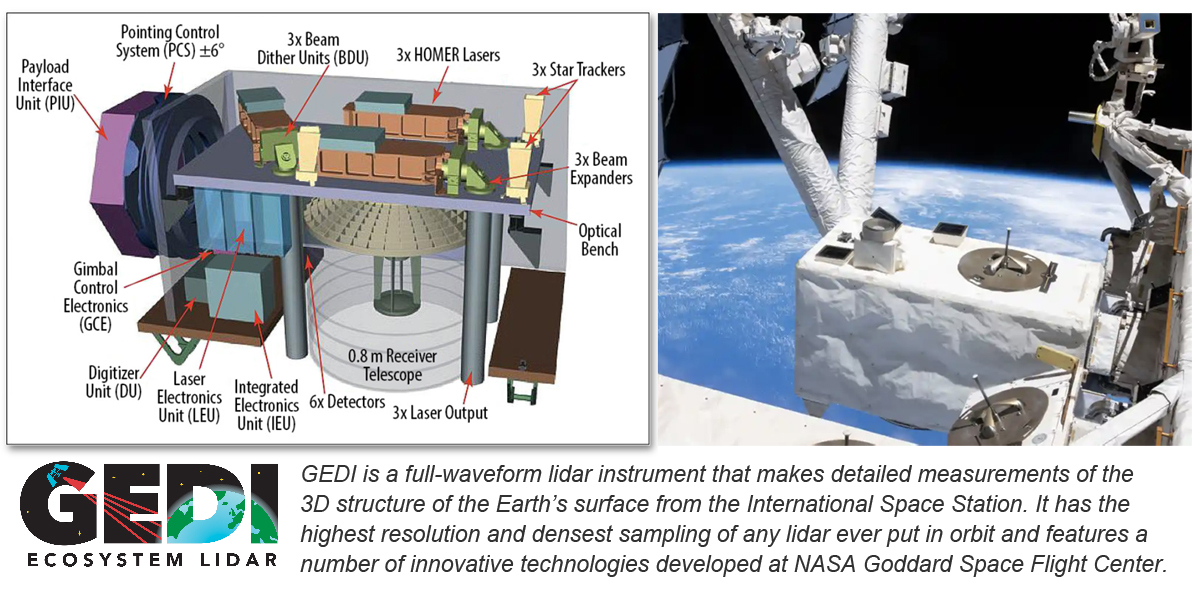
Our team visited 200 GEDI "pulses" distributed across the primary redwood reserves. Each pulse covered a 25-meter-diameter footprint, and trees within that area were measured for trunk volume, crown size, and height such that pulse biomass could be precisely estimated.
Our measurements show GEDI often grossly underestimates biomass by up to half. Why? GEDI metrics predicting biomass in these forests are based on canopy height, and height alone is a poor predictor of tall tree biomass. Trees of similar heights may have trunks of wildly different sizes.
This doesn't indicate a problem for the entire GEDI mission. Height is an adequate predictor of biomass in shorter forests with smaller trees (regenerating timberland in western North America, for example). However, for primary redwood forests, GEDI isn't the most effective tool, and this may be true in other tall forests. Spaceborne laser scanning is about as remote as sensing can be, but another promising tool flies closer to home.
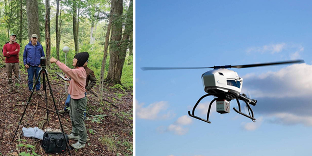
Airborne laser scanning (ALS) uses LiDAR (light detection and ranging) instruments mounted on airplanes to characterize topography and vegetation. Conveniently, 37,000 hectares of primary redwood forest were recently surveyed using ALS. Those data were important in co-locating GEDI pulses during our fieldwork and in developing new predictive equations for biomass estimation using ALS instead of GEDI metrics.
Redwood forests scanned by ALS were segmented into 2.5 million objects consisting of dominant and subordinate tree crowns to produce a comprehensive canopy inventory. Each object was scored for height and crown size to calculate volume. Predictive equations were developed by linking 500 objects to carefully measured trees distributed across the study area.
The ALS predictions are an improvement over GEDI, but biomass of trees with giant trunks (>5 meters diameter at breast height) is once again substantially underestimated. This "giant tree effect" means parkwide ALS biomass estimates are still conservative. Despite this shortcoming, ALS can effectively quantify live tree biomass across large areas of forest.
Our biomass maps reveal strongholds of long-term carbon storage and can help inform management. Ultrahigh-biomass areas (> 3,000 metric tons per hectare, purplish pixels) are rare. Across the entire study area, these exceptional stands account for only 1% of the primary forest. Biomass concentrations peak along low-elevation alluvial flats of Bull Creek and its confluence with the Eel River in Humboldt Redwoods State Park. This is exactly the landscape context facilitating early and extensive logging.
Low-biomass primary forests (< 1,000 metric tons per hectare, green pixels) also occur predictably—near park boundaries with private timberland, along edges of clearcuts within parkland, and at higher elevations with interspersed prairies. These biomass distributions can help establish context-specific targets for long-term recovery of primary forest edges and regenerating forests inside (white areas) and outside (gray areas) park boundaries.
Beyond live tree biomass, remote sensing has limited ability to quantify understory vegetation, standing dead trees, logs, and canopy structural features. For example, large redwood crowns often have enormous accumulations of epiphytic ferns, shrubs, and arboreal soil that support many additional species. Higher-resolution terrestrial laser scanning has great potential to capture the forest features overlooked by remote sensing, and it's the best tool for accurately quantifying individual trees without climbing them.
ALS combined with targeted terrestrial laser scanning and judicious direct measurements can be used to precisely map forest biomass, but this requires people working in the woods. The extra effort seems warranted given the scarcity of primary forests, the hopeful potential of restoration forestry, and the amazing capabilities of current technology.
Our article ends on a comforting note, "While technological advances continue to enhance the scope of forestry research, boots-on-the-ground measurements remain essential and will provide meaningful work for generations to come."
This story is part of Science X Dialog, where researchers can report findings from their published research articles. Visit this page for information about Science X Dialog and how to participate.
More information: Stephen C. Sillett et al, Ground-based calibration for remote sensing of biomass in the tallest forests, Forest Ecology and Management (2024). DOI: 10.1016/j.foreco.2024.121879
Journal information: Forest Ecology and Management
Marie Antoine and Steve Sillett have dedicated their scientific careers to climbing, measuring, and understanding the world’s tallest and largest trees. Since 2001, they have climbed more than a thousand trees together. Their work has been featured in National Geographic Magazine (coast redwood, October 2009; giant sequoia, December 2012), and their early adventures in forest canopy exploration were documented in Richard Preston’s The Wild Trees (2007). Both are members of the Department of Forestry, Fire, and Rangeland Management at Cal Poly Humboldt in Arcata, California. Steve is Professor, the Kenneth L. Fisher Chair in Redwood Forest Ecology, and author or co-author of 60 scientific articles
Subscribe to our newsletter
Stay updated on the latest technology, innovation product arrivals and exciting offers to your inbox.
Newsletter

