Share
Peru is harnessing cutting-edge Earth Observation technology to track deforestation in the Amazon with unprecedented detail and accuracy. GMV’s Antonio Tabasco explains how the country is turning forest monitoring into actionable tools for sustainability, compliance, and climate resilience.
The Peruvian Amazon covers most of the country and is home to some of the richest forests on Earth. These forests help fight climate change by storing carbon, however, things are changing quickly. In recent years, illegal logging, farming, and weak law enforcement have led to more and more forest loss. What was once considered an eternal rainforest is now disappearing fast, raising serious concerns among scientists and government officials.
The Mission in Peru
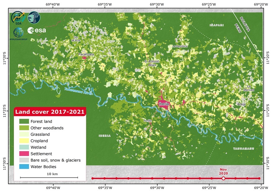
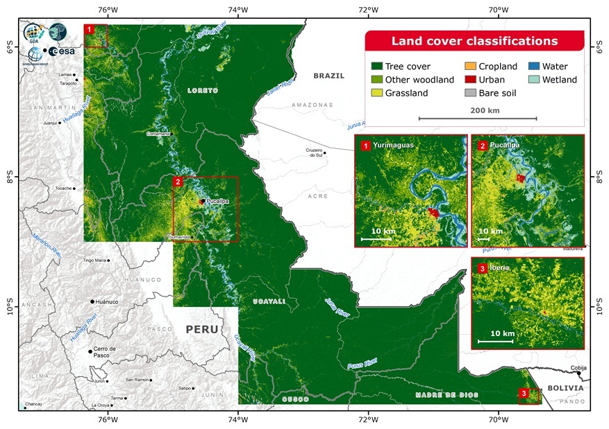
GMV supported World Bank and the European Space Agency (ESA) through the Global Development Assistance (GDA) programme, developing a monitoring system aimed at understanding how land use is changing in the Peruvian Amazon. The project focused on two regions—Yurimaguas and Iquitos—both of them hotspots for deforestation and land conversion.
Rather than offering a static view of the forest, this system provides sub-annual, 30-meter resolution updates that show how land is changing over time. It picks up changes not just yearly, but every few months, enabling near real-time monitoring. For Peru—where 53% of national emissions are tied to land-use change—this level of detail is critical.
This approach is quite innovative due to the combination of optical imagery from Landsat satellites and radar data from Sentinel-1, processed using the Continuous Change Detection and Classification (CCDC) methodology. This technique allows analysts to detect changes across space and time, such as a newly cleared area of forest or the early stages of an oil palm plantation.
Even in cloudy conditions, which are constant in the Amazon, the system remains functional thanks to the radar input. That is a big deal, since cloud cover has traditionally been one of the biggest barriers to consistent monitoring in tropical regions.
The use of both optical and radar imagery also makes it possible to identify types of land use that are difficult to distinguish with just one type of data. For example, radar data is especially helpful for detecting changes in surface texture or moisture levels, while optical data is better at showing color and vegetation health.
Collecting data is one thing. Turning it into something useful is another
In this project, GMV did not just produce deforestation maps—it helped build a methodology that ties these changes to financial mechanisms, especially sustainability-linked bonds (SLBs). These bonds reward countries or institutions when they meet specific environmental goals. But for that to work, you need to define and track Key Performance Indicators (KPIs) with accuracy and transparency.
GMV’s monitoring system delivers exactly that. By identifying what kind of land replaces lost forests—whether it’s palm oil forests, grassland, cropland, or urban areas—it gives policymakers and investors the nuance they need. A forest lost to natural disturbance tells a different story than one cleared for commercial crops.
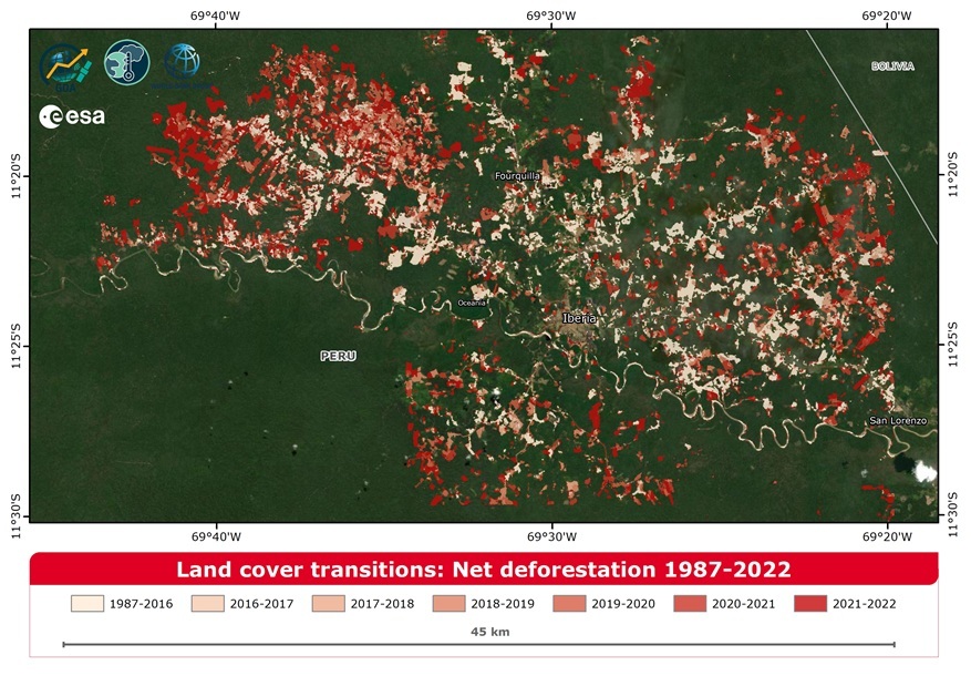
Take Yurimaguas, for example. The satellite data revealed that deforestation there peaks between March and September, coinciding with the dry season. That detail is not only academically interesting. It allows environmental targets to be tailored to seasonal dynamics, making them more realistic and enforceable in a policy or investment context.
This information is particularly valuable for designing performance-based contracts, which are becoming more common in conservation finance. Governments and donors want to know not only that forests are being protected, but how and why changes are occurring.
A Foundation for Better Decisions
The implications of this activity go far beyond climate finance. The data generated is now being used for land-use planning, climate mitigation, and biodiversity conservation. It helps identify degraded areas suitable for reforestation, spot illegal encroachments near protected zones, and assess how infrastructure like roads is affecting forest stability.
The high level of detail in the data means it is not just useful for the whole country—it can also help at regional or local levels, where many are decisions actually made. This kind of information also helps countries follow international rules, like the EU law that bans products linked to deforestation. It provides clear proof about the condition of forests, how the land has been used over time, and whether the activities are legal.
In Peru’s case, this is particularly important because agricultural expansion—often legal in some areas and illegal in others—is a major driver of deforestation. Being able to demonstrate compliance at the parcel level gives producers and exporters a chance to participate in global markets under stricter environmental standards.
Lessons Learned
First, applying EO technology in the real world is not only about technical accuracy. The data has to be interpretable and trusted by both governments and citizens.
Second, one-size-fits-all approaches don’t work. In Yurimaguas, much of the deforestation was driven by palm oil and cattle ranching. In Iquitos, it was more connected to smallholder farming and shifting cultivation. By tailoring classification schemes and training data to each local context, the system achieved accuracy levels above 90%—essential for making the information actionable.
Third, combining radar and optical imagery allowed the platform to operate during Peru’s long cloudy seasons avoiding gaps in forest monitoring. Even so, the team found that relying too heavily on optical data (like Landsat) still skewed change detection toward drier months. That insight points to future opportunities for improvement.
Looking Forward
This work in Peru can serve as a model for other countries in the Amazon and elsewhere that are facing problems with deforestation and trying to grow in a more sustainable way. It shows that we can track environmental changes as they happen and use that information to support both local decision-making and international funding efforts.
The same technology could also be used to monitor other ecosystems under pressure—such as mangroves, wetlands, and dry forests—offering similar benefits in terms of both policy support and climate finance. This monitoring is especially important now, as many countries are preparing or implementing Nationally Determined Contributions (NDCs) under the Paris Agreement outlining each country's commitments to reduce greenhouse gas emissions and adapt to climate change.
In summary, Earth Observation can do more than just watch what is happening. It can become a powerful tool to help people take action and take responsibility.
Antonio Tabasco, Head of GMV's Remote Sensing and Geospatial Services Division
Subscribe to our newsletter
Stay updated on the latest technology, innovation product arrivals and exciting offers to your inbox.
Newsletter

