Share
The Atlas of Global Surface Water Dynamics illustrates the changes in the Earth’s lakes, rivers and wetlands over time.
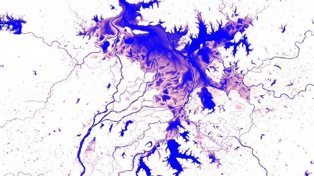
The surface area of the lake Poyang in China changes dramatically year by year. 22 Oct 2020
The Atlas provides a better understanding of the consequences climate change and human actions have for the planet’s surface water resources.
It is impossible to overstate the critical importance of water in our daily lives. Surface water bodies – including lakes, ponds and rivers – are particularly important as sources of water for domestic, industrial and agricultural use.
As the Earth’s surface water is intensely dynamic, our knowledge about where waterbodies can be found has not always been accurate. Waterbodies move, whole lakes dry up and new rivers and lakes form, which makes mapping these moving targets difficult.
Building on a project that combined thousands of years of computer time with millions of satellite images, the Atlas of Global Surface Water Dynamics compiled by the European Union’s Joint Research Centre (JRC) describes the important role that surface water plays for our planet’s climate and biodiversity, as well as virtually every aspect of our daily lives.
The Atlas documents the science behind a set of truly unique maps, which include time, and illustrates the changes in surface water resources over the past 35 years.
The scientists believe that the Atlas can improve our understanding of the consequences of climate change and human action on surface water resources, and that clearer understanding can help decision-makers to plan environmental actions and design effective policies aimed at the sustainable management of surface water resources.
Mapping the history of water
In 2013, a small team of JRC scientists embarked on a massive project to map the history of surface water presence on Earth.
Working in collaboration with Google Earth Engine, the JRC team processed some 4 million satellite images from the U.S. Geological Survey (USGS), the National Aeronautics and Space Administration (NASA) and the EU’s Copernicus programme.
In 2016, the JRC and Google Earth Engine made public the product of the partnership, the Global Surface Water Explorer (GSWE).
The Global Surface Water Explorer is an interactive online platform that maps the location, distribution and changes of the world's surface waters over the past decades. The platform is updated annually.
In 2019, the GSWE was adopted as a basis for the UN Environment’s assessment of the Agenda 2030 Sustainable Development Goal’s target 6.6.1 concerning freshwater ecosystems.
Based on the online platform, the Atlas of Global Surface Water Dynamics presents the wealth of knowledge gathered by the scientific team in an easily accessible format that is readable to everyone.
Through a series of maps, case studies and beautiful images, this Atlas brings the reader on a journey through some of the world’s most fascinating examples of surface water changes, which highlight the beauty and fragility of the environment, and the need to preserve this precious resource.
Sources: All images Alan Belward using Landsat 5 and 8 imagery, courtesy USG
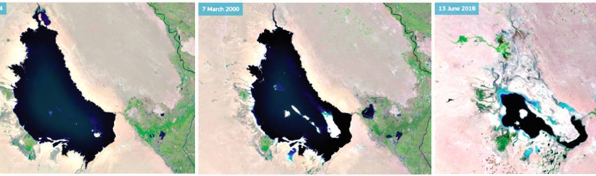
Until the early years of this century, Razzaza was Iraq’s largest freshwater lake. Increased water abstraction from the Euphrates and Habbaniyah in recent years (mainly for crop irrigation) means less excess water flows onwards into Razzaza, and as a consequence the lake is rapidly drying up and becoming increasingly saline. Much of the lake has vanished since 2000. The contracting lake is losing its fish stock and diversity, along with its plant and bird life. The land degradation around the lake affects both biodiversity and human well-being. Livelihoods from recreation, fishing and farming are all in sharp decline with only one species of fish reported as remaining in the lake.
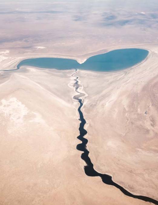
Source: Patrick Schneider on Unsplash.com
Once one of the world's largest lakes, the Aral Sea used to be fed by two main rivers, the Amu Darya and Syr Darya. By the 1960s much of the water from these was being diverted to irrigate freshly established cotton fields. As a consequence, the Aral Sea began to contract. In the early 1980s the lake was still largely one contiguous waterbody (albeit smaller than the original), but by the mid- to late-2000s it had been transformed into separate residual lakes, covering only 10 % of its former area.
Source: https://joint-research-centre.ec.europa.eu/jrc-news-and-updates_en
Subscribe to our newsletter
Stay updated on the latest technology, innovation product arrivals and exciting offers to your inbox.
Newsletter

