Share
Utilising 30 years of expertise in geospatial technologies, the European Commission's Joint Research Centre has launched a new online resource on deforestation and degradation … one that will help protect and restore the world’s forests and ensure that Europeans consume deforestation-free products.
When tasting chocolate, have you ever thought part of a forest might have been cut to make space for the cocoa needed to make the delicious tablet?
In fact, half of the cocoa produced worldwide is imported into Europe. However, it is not straightforward to trace back the cocoa production for the chocolate we eat. The JRC has used 30 years of expertise in geospatial technologies to provide a global map of the extent of forests in 2020, to be used in a new observatory on deforestation.
The EU observatory on deforestation and forest degradation is now up and running, making its maps and datasets on changes in the world’s forest cover and associated drivers publicly available. It will support the EU’s new rules on deforestation-free products, laid down to guarantee that the products placed on the EU market or exported from it do not originate from deforested land or have not contributed to forest degradation.
In addition, the new rules aim to reduce carbon emissions and biodiversity loss caused by EU consumption and production of a series of commodities, and to address deforestation and degradation resulting from agricultural expansion to produce them. As a major economy and consumer of commodities such as soy, beef, palm oil, wood, cocoa, coffee, and rubber, as well as some of their derived products, such as leather, chocolate, tyres, or furniture, the EU is taking action to curb the EU market's impact on global deforestation and forest degradation.
These new rules are laid down in the Regulation on deforestation-free products (EUDR) and will apply by the end of 2024. Building on existing monitoring tools, including Copernicus products and other publicly or privately available sources, the observatory will facilitate access to information on supply chains for public entities, consumers, and businesses.
The observatory in detail
The observatory is structured around three main components: global forest monitoring, production and trade of commodities, and EU tools for forest monitoring.
The Global forest monitoring component provides interactive visualisations:
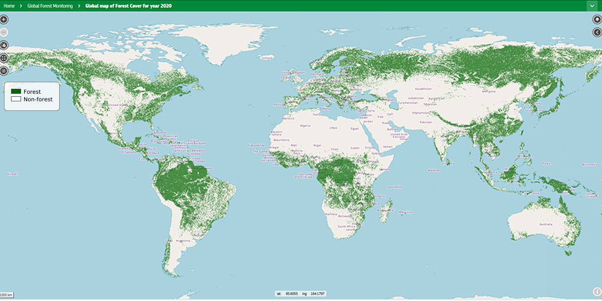
• Global forest cover 2020: a spatial dataset (above) showing the global forest cover presence in year 2020 (cut-off date in EUDR) at 10m spatial resolution obtained through the integration of global spatial datasets on land cover.
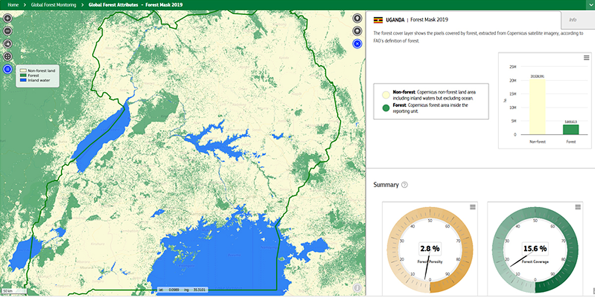
• Forest attributes (relevant for forest degradation reported by FAO): global spatial dataset of key landscape features about forest derived from the Copernicus global land cover map of year 2019 at 100 m resolution. That pictured above is the country-level data for Uganda.
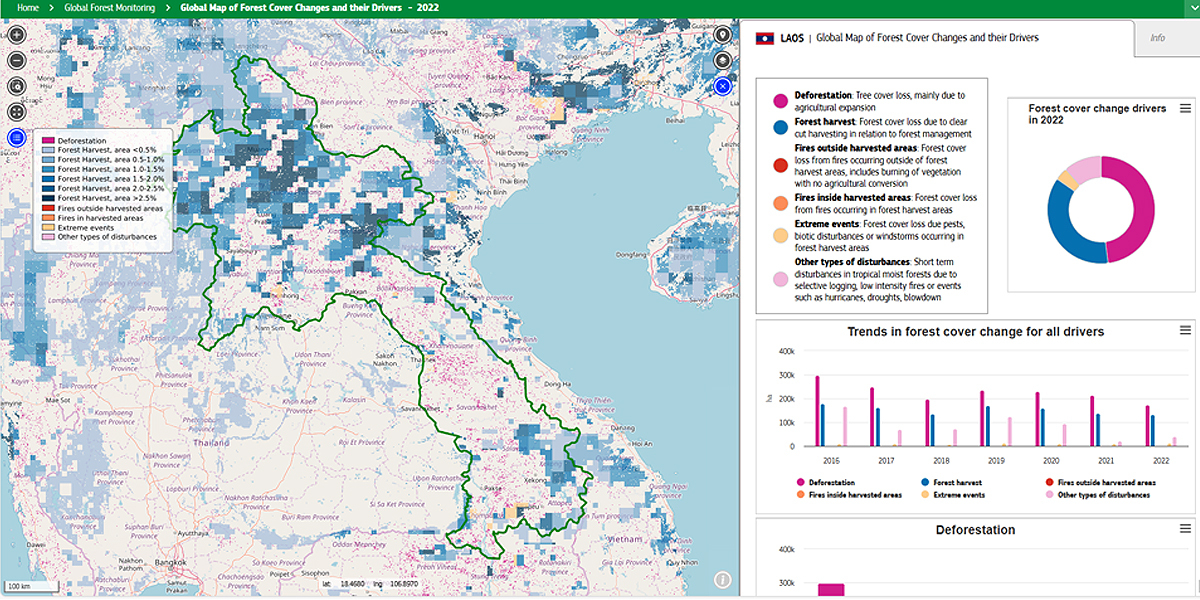
• Forest cover changes and drivers: global spatial dataset of global forest disturbances such as deforestation, forest harvest, selective logging, forest fires, extreme events, insect defoliations, etc. during period 2015-2022. Pictured above is the country-level dataset for Laos.
In addition, the Tropical Moist Forest dataset from the Joint Research Centre provides information on changes in forest cover from 1990 up to the year 2021 in the humid tropics. The wall-to-wall maps at 0.09 ha resolution (30m) depict the tropical moist forest extent and the related disturbances (deforestation and degradation), and post-deforestation recovery (or forest regrowth).
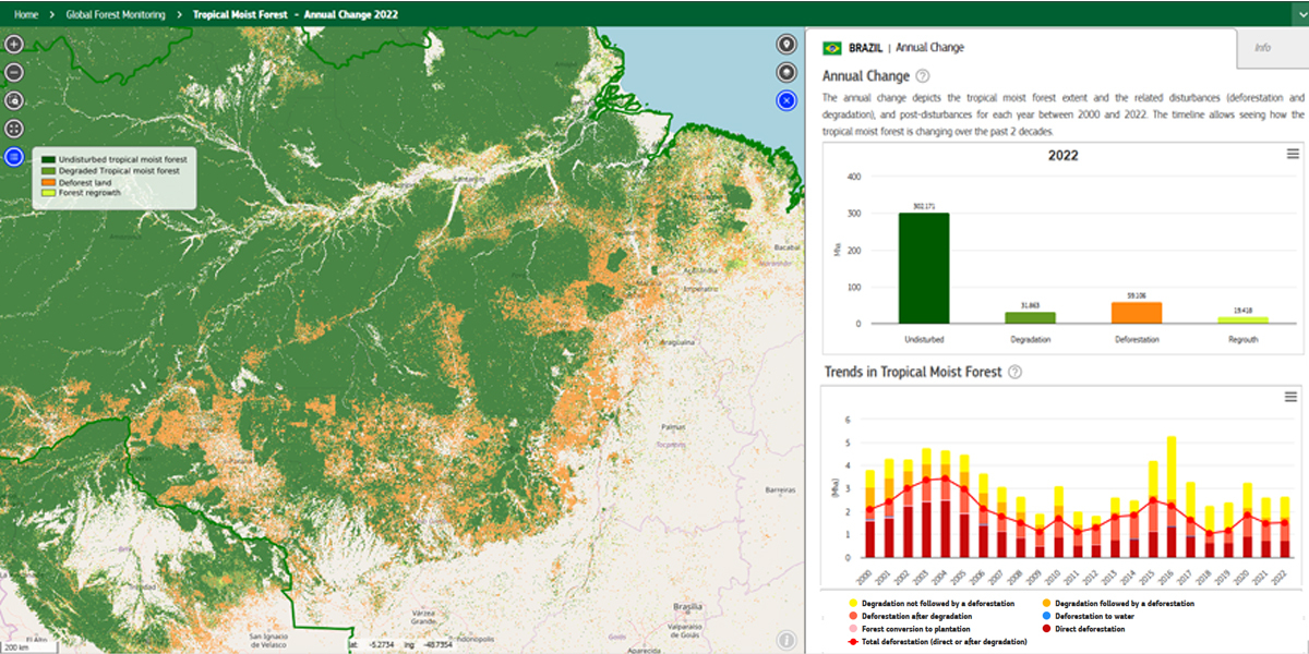
Deforestation refers to a change in land cover (from forest to non-forested land) when degradation refers to a short-duration disturbance in a forest remaining forested such as selective logging, fires and unusual weather events (hurricanes, droughts, blowdown). Pictured above is the country-level dataset for part of the Amazon rain forest in Brazil
The component on production and trade of commodities provides interactive visualisation of global datasets on national-level production of commodities and products subject to the EUDR, and the volume of trade of such commodities between third parties and the EU:
• Production: values of production quantities and area harvested in each producing country based on FAOSTAT (FAO food and agriculture data) sources
• Trade flows: annual bilateral trade of the EUDR product list between countries. The data shown are based on FAOSTAT and UN COMTRADE (UN global trade data platform).
• Toolbox for the download and analysis of production data (FAOSTAT), and bilateral trade (FAOSTAT and UN COMTRADE)
The JRC developed a land footprint approach by assimilating trade statistics of the key commodities (cocoa, coffee, palm oil, soy, cattle, wood, and rubber) and forest cover change maps (identifying deforested areas converted into agricultural land), thanks to transdisciplinary teams integrating different types of data streams.
The EU tools for forest monitoring include Earth-Observation-based tools, allowing near-real-time monitoring of changes, landscape pattern analysis, overview of tree species distributions, as well as providing reference data and a toolbox for image processing.
Source: European Commission JRC
Subscribe to our newsletter
Stay updated on the latest technology, innovation product arrivals and exciting offers to your inbox.
Newsletter