Share
The European Association of Aerial Surveying Industries (EAASI) marked a milestone with its most successful Summit to date in Dubrovnik, bringing together 106 participants from 24 countries.
The event highlighted advances in spatial data infrastructure, artificial intelligence, and sustainable aviation, alongside focused discussions on operational challenges such as GPS jamming and air traffic coordination. EAASI also confirmed a leadership transition, appointing Dr. Roland Stengele as President. Beyond the Summit, year-round committee work—particularly through the Air Traffic Control Committee—continues to deliver practical tools and shared resources that strengthen cross-border aerial surveying operations across Europe.
The European Association of Aerial Surveying Industries concluded its most successful Summit in Dubrovnik last November, welcoming 106 participants from 63 organizations across 24 countries. Since its incorporation in June 2019, EAASI has evolved from informal discussions among European aerial surveying companies into a structured organization delivering tangible value throughout the calendar year. While the annual Summit provides the community's most visible forum for strategic dialogue, the Association's real impact stems from sustained committee work addressing operational challenges facing the crewed aerial surveying sector.
Strategic Insights and Technical Innovation in Dubrovnik
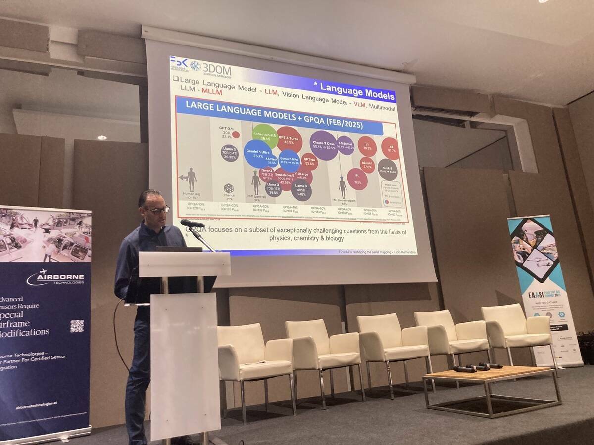
The Dubrovnik Summit delivered a comprehensive programme featuring speakers from national mapping agencies, industry leaders, and academic institutions. Tomaž Petek, President of EuroGeographics, outlined the transformation of Europe's spatial data infrastructures toward integrated ecosystems requiring strong public-private partnerships. Fabio Remondino from Fondazione Bruno Kessler examined how artificial intelligence is reshaping aerial mapping workflows, highlighting Multimodal Large Language Models for annotation-less semantic segmentation of point clouds. Three focused panel discussions addressed GPS jamming responses, sustainable aviation practices, and public-private partnerships, while sponsor presentations featured real operational use cases. The Summit also showcased Outstanding Thesis Award winner Dr. Weixiao Gao, whose research on automated semantic understanding of urban textured meshes demonstrates pathways from aerial surveying data to actionable 3D city models.
Leadership Transition and Board Appointments for 2026
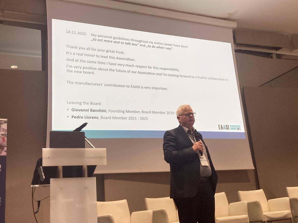
During the Extraordinary Annual General Meeting on 19 November, EAASI members elected the Board for the 2026 term and confirmed a significant leadership transition. Florian Romanowski stepped down after completing his three-year presidential mandate, expressing appreciation to the community for their trust and collaboration. The Board subsequently appointed Dr. Roland Stengele, CEO and shareholder of BSF Swissphoto, with over two decades of industry experience, as the new President. Simon Musaeus, a founding board member and EAASI's first President from 2019 to 2023, was elected Vice President, while Rachel Tidmarsh, CEO of Bluesky International, was re-elected as Treasurer. The complete Board also includes Engelbert Breg, Aicke Damrau, Søren Jespersen, Patrik Meixner, Luca Rampa, and Florian Romanowski.
Committee-Driven Progress Beyond the Annual Summit
Beyond the annual Summit, EAASI's committee structure drives continuous improvement in operational conditions. Patrik Meixner leads the Universities and Student Engagement Committee, fostering connections with emerging talent. Engelbert Breg heads the Industry Technical Standards Committee, addressing harmonization and certification. The Air Traffic Control Committee, currently under the leadership of Søren Jespersen, exemplifies how sustained engagement delivers practical solutions to long-standing industry challenges.
Air Traffic Control Engagement Delivering Practical Tools for Members
The ATC Committee responds to difficulties in gaining effective contact with bodies including EASA, EUROCONTROL, and national Air Navigation Service Providers. Emerging from discussions at the Athens 2024 Summit, its work focuses on increasing visibility of aerial survey operations and explaining specific operational constraints—weather windows, seasonal work patterns, traffic, and ATC restrictions—to promote better understanding and information sharing on flight-permit procedures.
The Committee has developed three concrete tools available to members. A standard ATC letter in English, hosted on the EAASI website, provides consistent documentation for technical proposals and flight-permit requests. A detailed awareness presentation briefs national ATC authorities on the nature of aerial survey flying and operational flexibility required. Most significantly, the Committee maintains a collaborative flight-permit database covering fifteen countries, designed to remain current through member contributions. This living resource reduces uncertainty and supports cross-border operations by sharing practical knowledge on permit procedures across European jurisdictions. The Committee is now evaluating its future direction, including whether its initial mandate is fulfilled and potential new topics to address.
The combination of the annual Summit's strategic dialogue and year-round committee work positions EAASI as the central forum for Europe's crewed aerial surveying community. As President Stengele noted, "With the right balance of cooperation and competition, and by working closely with partners across Europe, we can ensure EAASI continues to grow in relevance and impact." This dual approach—bringing the community together annually while maintaining focused working groups throughout the year—creates collaborative frameworks addressing both immediate operational needs and long-term strategic challenges.
Subscribe to our newsletter
Stay updated on the latest technology, innovation product arrivals and exciting offers to your inbox.
Newsletter

