Share
Monitoring the integrity of infrastructure and natural landscapes such as riverbanks is a vital yet often underestimated task in maintaining public safety and preserving the environment. Dave Foster, Ulrich Zangerl, and Bernhard Groiss explain what happens when surveyors need to measure the hidden undersides of bridges, or the ever-eroding edges of a riverbank tucked away in a narrow urban waterway.
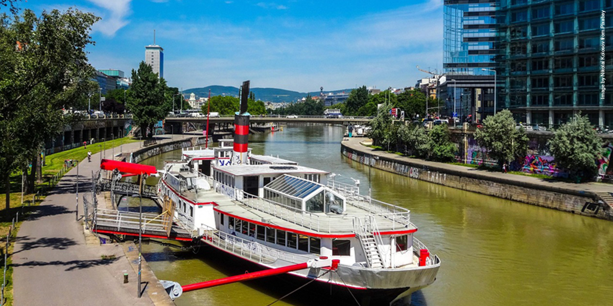
The Danube Canal, a 17-kilometer branch of the Danube River that snakes through the heart of Vienna (pictured above), presents a unique challenge to surveyors. Hemmed in by concrete walls, crisscrossed by busy bridges, and constantly bustling with commercial and leisure shipping traffic, this stretch of water demands meticulous maintenance — yet leaves little room for conventional survey methods.
To maintain the canal’s integrity and manage risks such as bank erosion and flood vulnerability, a comprehensive and precise record of its terrain — both above and below the waterline — is essential. Until recently, this was a logistical nightmare.
“The narrowness of the canal, the amount of traffic, and the limited access from the banks make it incredibly difficult to conduct thorough terrestrial surveys. We needed a flexible, high-resolution solution that could operate effectively from a vessel,” says viadonau – a Viennese business charged with ensuring the smooth operation of the Danube waterway,
Enter boat-based kinematic laser scanning — a cutting-edge surveying method that promises both efficiency and precision.
A floating revolution
Unlike static terrestrial laser scanners (TLS), which are mounted on solid ground and require surveyors to physically access the area of interest, kinematic scanning takes the scanner mobile — mounting it on a moving platform like a car, drone, or, in this case, a survey boat. The scanner records millions of 3D points per second as it moves, creating a richly detailed digital model of the surrounding environment.
“The ‘hybrid’ aspect of the VZ-600i is key,” explains a RIEGL engineer involved in the project. “It can operate in static mode for ultra-precise land surveys, and in kinematic mode for fast, wide-area coverage from moving platforms. That’s ideal for something like the Danube Canal, where time, access, and safety are all concerns.”
To handle the constantly shifting position and motion of the boat, the scanner is integrated with a high-accuracy positioning system, combining GNSS (Global Navigation Satellite System) data with measurements from an Inertial Measurement Unit (IMU). The result is a stabilized, georeferenced 3D point cloud, corrected for motion and accurately anchored in real-world coordinates.
Pushing technical limits
The scanning operation on the Danube Canal faced a litany of challenges. The team had to contend not only with narrow waterways and frequent bridges — which often blocked GNSS signals entirely — but also with the dynamic motion of the boat and a lack of distinct landmarks along the canal walls, which could complicate data registration and accuracy checks.
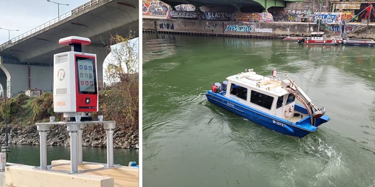
To address these obstacles, viadonau developed a custom scanning setup. A sturdy mounting frame was built to secure the VZ-600i to the roof of the survey vessel (pictured above), allowing it to maintain an unobstructed 360-degree view. The survey route was executed in three full passes: one with a rotating scanner setup and two with fixed angle scans — one focused on each riverbank.
Sensor synchronization and post-processing were vital components. “A major hurdle in dynamic scanning is data drift and misalignment due to motion,” explains the RIEGL team. “To minimize this, we used correction data from the Austrian Positioning Service (APOS), which allowed us to post-process GNSS data and greatly reduce positioning errors, especially in GNSS-denied zones under bridges.”
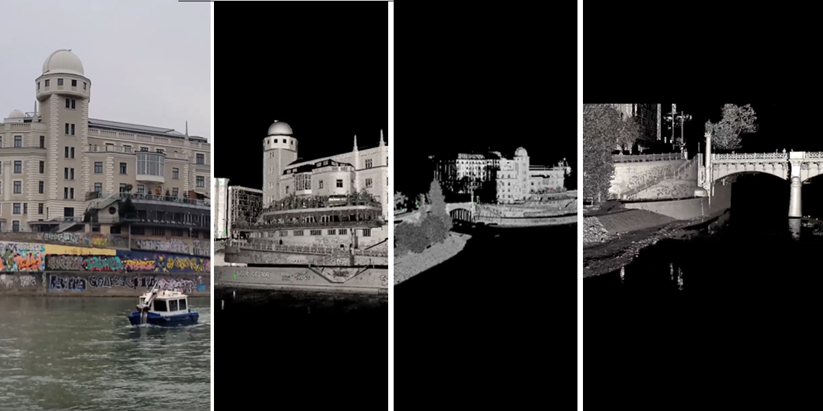
Additionally, twelve reflective targets were installed along the scan area and precisely surveyed from land. These reference points served as control markers, enabling even finer alignment and georeferencing of the point clouds. The final result? A 3D dataset with a spatial resolution of just 1.5 centimeters and a positional accuracy of 2 to 3 centimeters — a level of detail that far exceeds what’s typically achievable in challenging environments like this.
Transforming infrastructure
The implications of this success go far beyond a single project. With this demonstration, RIEGL and viadonau have proven that highly detailed, repeatable surveys of complex waterways can be carried out efficiently — without requiring surveyors to physically access hazardous or inaccessible zones.
For viadonau, the benefits are immediate. High-quality 3D scans can now be conducted on a regular basis, creating a time-based dataset that will reveal how the canal environment changes over time. Early signs of bank erosion, structural degradation, or sediment buildup can be detected with precision — and addressed before they become costly or dangerous problems.
Moreover, the data doesn’t just serve engineers and hydrologists. Environmental planners, urban developers, and civil protection authorities can all benefit from having a high-fidelity digital model of the waterway and its surroundings.
“This isn’t just about monitoring infrastructure,” says viadonau. “It’s about integrating digital tools into the ongoing stewardship of our waterways. The better we understand these environments, the better we can protect them — and the people who live and work around them.”
A glimpse of the future
Boat-based laser scanning using hybrid TLS systems like the VZ-600i is poised to become a mainstream technique for surveying rivers, coastal zones, harbors, and even urban canals. It offers a unique combination of safety, speed, and resolution that traditional survey methods can’t match.
As demand grows for smarter, more sustainable infrastructure management, the need for high-quality geospatial data will only increase. The work of viadonau and RIEGL provides a glimpse of that future — where once-unreachable places become fully visible in digital form, and critical decisions are informed by accurate, actionable data.
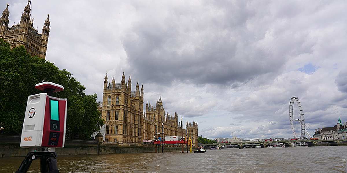
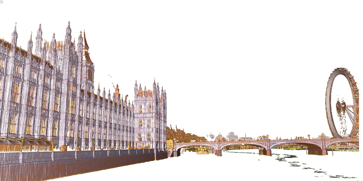
Scanning on London’s historic River Thames
Following the success on the Danube Canal, boat-based laser scanning has made its way to the UK — this time along one of the world’s most iconic waterways: the River Thames. Winding through the heart of London, the Thames presents a complex surveying environment characterized by historic bridges, busy boat traffic, variable tides, and an ever-changing urban skyline.
From Tower Bridge to Westminster and beyond, the undersides of structures and embankments along the Thames have long posed challenges for conventional surveying. Limited access from land, fluctuating water levels, and high commercial and tourist vessel activity make it difficult — and often unsafe — for surveyors to operate using traditional static equipment.
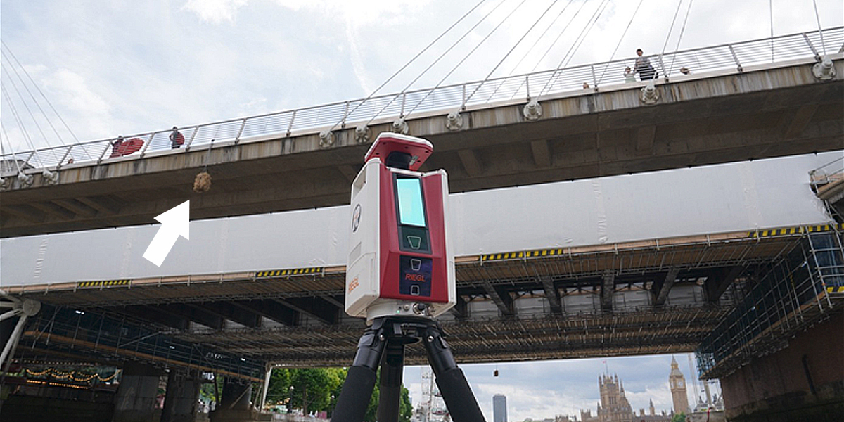
The RIEGL team had the chance to put a VZ-600i on a boat (pictured below) and sail along the Thames in kinematic (rotating) mode. To overcome GNSS interference from bridges — particularly prevalent in central London — the RIEGL VZ-600i uses a GNSS/IMU system supported by GNSS RTK correction service.
Around 7.5 miles of River were surveyed in just under an hour, with an average speed of around 8knts. The survey was only conducted with a rotating scanner set-up. However, the level of detail extracted from the survey was stunning.
Early results from the Thames scan are already revealing valuable insights. Previously inaccessible areas beneath heritage bridges have been captured in high detail, enabling structural engineers to assess aging masonry and detect early signs of stress or erosion. Data from an earlier survey conducted with the RIEGL VMX-2HA mobile mapping system was integrated to produce a coherent points cloud. Surface level data together with that obtained from the river underneath the bridges enables engineers to study each bridge in detail.
Similarly, riverbank geometry near flood-prone areas is now mapped with centimeter-level accuracy, supporting the city’s climate resilience planning.
Amusingly, the survey also picked up the bale of straw (arrowed in picture below) that is traditionally hung under the arch of Hungerford Bridge (for Charing Cross station) to warn of lower clearance A nice touch! There are many iconic buildings adjacent to the River Thames – these snap shots show just a glimpse of what is possible from a static measurement device, used in a kinematic mode.
Dave Foster is Managing Director at RIEGL U.K., Ulrich Zangerl is Head of Geoinformation Team at viadonau, Bernhard Groiss is Senior Technical Expert, LIDAR Forestry Applications at RIEGL
Subscribe to our newsletter
Stay updated on the latest technology, innovation product arrivals and exciting offers to your inbox.
Newsletter

