Share
How Marine Spatial Data Infrastructures (MSDI) is now core to Maritime Services and e-Navigation
It was not very long ago that many in the Hydrographic Office (HO) community considered Marine Spatial Data Infrastructure (MSDI) as something of a distraction from the core business of providing navigational products and services to the maritime user. That view has been turned on its head recently with the realisation that the policies, standards and technologies that comprise MSDI are the same as those underpinning e-Navigation. This message came across loud and clear during the back-to-back expert meetings on marine geospatial information of the IHO (International Hydrographic Organisation), OGC (Open Geospatial Consortium) and UN-GGIM (United Nations Committee of Experts on Global Geospatial Information Management) hosted by the German Federal Maritime and Hydrographic Agency (BSH) in Rostock earlier this year and in the report and white paper presented at the online Tenth Session of the UN-GGIM held late Aug and Sep 2020.
Since its inception 15 years ago, the IHO MSDI Working Group has grown steadily in importance and influence. Initially set up in 2007 in response to the inclusion of ‘environmental protection and economic development’ into the IHO’s constitution, and more recently to deliver the IHO’s objective that hydrography is “not just for charting”, the MSDI Working Group is now at the heart of how a modern HO views and manages its data more generally.
Over the last 20-year period, a steadily growing number of HOs have supported the release of exchange datasets in S-57 format under a re-use licence, or in some cases, source datasets under a similar arrangement or open licence. However, this is not the case everywhere and, in many areas, navigational products are still being used for non-navigational purposes because there is a lack of viable and legitimate alternatives. The practice of digitizing or scanning and geocoding paper charts prevalent in the 1980s and 1990s still goes on but has been supplemented by similar misuse of their electronic equivalents. Licensing conditions are being interpreted unevenly, or ignored, differences in pricing between applications, uses and markets is illogical, and arguably unsustainable. Moreover, products and services designed for the navigator are inappropriate and can be misleading when used for purposes for which they were never intended.
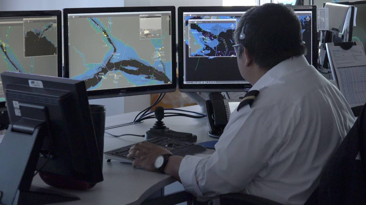
Image above: Example of electronic mapping at a U.K. port monitoring vessel traffic
The lack of acceptable and viable alternative products and services for non-navigational use in many geographic regions has caused consternation throughout the industry and is leading to a radical rethink as part of the IHO’s five-year strategic plan. Currently in draft form, the strategy document responds to a growing need for wider access and onward use of hydrographic data by an increasingly diversified customer base, while at the same time strengthening the IHO’s core principles of promoting hydrography internationally and providing guidance, advice and capacity building. Hydrography is a discipline that is growing in importance and international visibility due to increasing use of our seas and oceans, coupled with the influence of marine spatial planning, and the impact of pollution and climate change.
The IHO MSDI Working Group considers e-Navigation as a ‘use case’ for MSDI, but this wasn’t widely appreciated until the various layers of data, products, services and end user applications needed to make e-Navigation a reality, became much clearer. Maritime services rely on exactly the same principles of data management ‘best practice’ and publishing via web services as any other geospatial information-based application. The transition from paper to electronic charts and now to maritime services comprising for example, weather, port access and ship routeing information, is now an upper most priority of the IHO.
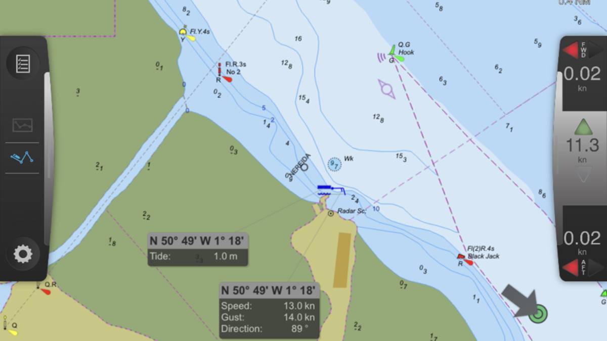
Above image: Screen shot example from a Trelleborg ‘Safe Pilot’ Portable Pilot Unit showing how maritime pilots use data including water depths, vessel tracks, weather and tide information.
For this paradigm shift to be delivered, the ISO standard for geospatial information (ISO 19100); parentage of IHO S-100, and the assertion that maritime services will be built on S-100 based specifications, is now reinforcing this growing realisation. The next 12 -24 months or so will be a vital watershed as the HO community transitions from being a provider of navigational products to supporting the development and delivery of maritime services. However given the wide range of players involved, exactly how these services will be distributed to the mariner is yet to be fully determined.
In parallel with the shipping and ports sector gearing up towards exchanging and consuming information via maritime services, the UN-GGIM is lending its considerable weight to ensuring that marine geospatial information gets the same attention as other domains and that the data required to deliver and monitor the UN’s Sustainable Development Goals is readily available (Ref. 1*). This cause was advanced considerably at the meetings in Rostock, with the publication of the Marine SDI Concept Development Study Report by the OGC (Ref. 2*) and the further development of a comprehensive Use Case that was subsequently submitted to UN-GGIM Tenth Session this year.
Along with the Marine Working Group’s report entitled ‘A reference on the benefits and challenges of providing accessible marine geospatial information’, the white paper (Ref. 3*) reports on the conclusions of a use case exercise with interviews of Member States. It concluded firstly that access to marine geospatial information will play a critical role in the global response to many of the larger, societal and environmental issues the world currently faces. Knowing where people, events, and activities are, and their relationship to one another in the marine domain, is essential for informed policy and decision-making. Not only is real-time information needed to prepare for and respond to natural disasters and political crises, but geospatially based services are helping governments make data-driven, evidence-based decisions; develop strategic priorities and measure and monitor outcomes.
It also concluded that contributing to the availability and accessibility of comprehensive location-based information will benefit and enhance the role and relevance of many sectors within the marine domain, including but not limited to commercial shipping and safety of navigation; marine resources, the Blue Economy, and marine spatial planning; emergency management; maritime boundaries and tenure; and law enforcement and defence.
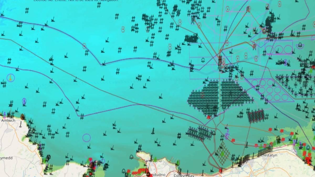
These initiatives provide further evidence of the need for marine mapping (as opposed to charting) that customers of OceanWise’s intelligent mapping products and services have enjoyed in the UK, Northwest Europe and the Middle East for some time (Figure 1). Customers who are willing to pay for marine mapping products and services – in exactly the same way that the shipping and ports are willing to pay for authoritative, timely and easily accessible information – means that data that is Findable, Accessible, Interoperable and Reusable (FAIR) does not have to be made available free of charge and provides a sustainable revenue stream for innovation and maintenance.
“In our experience organisations prefer to pay for data as it creates a customer-supplier relationship that they appreciate. For example, when you are responsible for implementing marine spatial planning, responding to an emergency or developing an offshore renewable energy scheme; timely, up to date and easily accessible data is your priority. Customers tell us again and again that accurate, comprehensive, fit for purpose data and good customer service is worth paying for”, explains Caroline Levey, Operations Director at OceanWise.
The fact that free data may not remain free for ever, or its quality or currency may suffer when budgets are cut, is uppermost in the minds of those that rely on these datasets to do their job and deliver on their organisational objectives.
The reason why there have been restrictions on developing geographic coverage – that has precluded the provision of mapping globally – is because of a lack of access to data. The solution has to be more HOs allowing their data to be accessed under re-use licences, so that organisations (like OceanWise) would be able to serve the growing portfolio of users that are currently ‘making do’, and at the same time enhance the credibility – and potentially revenues – of those HOs that have to date not been able to engage in the process.
The UN-GGIM is hoping to address this deficit at a policy as well as a technical level. The recently launched Integrated Geospatial Information Framework (IGIF) provides a reference and a mechanism for countries to develop and strengthen their national and sub-national arrangements in geospatial information management and related infrastructures. The IGIF leverages seven underpinning principles, providing eight goals and nine strategic pathways for governments to establish more effective geospatial information management practices and policies (Figure 2).
At the UN-GGIM Marine Working Group meeting in February; participants endorsed the IGIF and committed to ensure that marine geospatial data is included, and that the need to improve safety on inland waterways and achieve land-sea data interoperability was highlighted and addressed. How the IGIF can support these and the goals of the marine community generally was prominent in the discussions of the working group. The fact that it was only formed in 2018 is testament to the commitment shown by everyone involved.
Fundamental Marine Geospatial Themes are required for:
✓ Baseline measurement
✓ Evidence-based policy making
✓ Implementation of actions
✓ Monitoring and reporting.
How this will come together, including delivering on the UN-GGIM’s promise that ‘no nation state will be left behind’, still requires extensive work and participation, but there is little doubt that substantial progress is being made and that the cross-working and inclusive approach pioneered within IHO is beginning to bear fruit. Challenges remain, such as how HOs engage and work with the private sector, and how the business model for maritime services will evolve, but by following the collegiate approach taken so far, the future looks extremely promising.
About the Authors:
John Pepper, whilst at the UK Hydrographic Office (UKHO), and Mike Osborne set in motion actions that led directly to the setting up of the IHO MSDI Working Group in May 2007. John chaired the Working Group until 2010 when he left UKHO to help set up OceanWise, a leading provider of marine data management, publishing and mapping products and services to the public, ports and offshore renewable energy sectors. Mike is the Managing Director of OceanWise and along with John, has been pioneering the development of marine mapping for over 20 years, tirelessly battling for better availability to marine data which continues to this day.
OceanWise uses open API technology and standards such as OGC web mapping services and IMO Application Specific Messaging (Message 8-1-31 for TideMet) to deliver geospatial and real-time monitoring data to users. OceanWise is participating in the development and adoption of the emerging specifications under S-100.
Figures:
Figure 1 – Example of OceanWise’s product ‘Marine Themes’ which comprises the fundamental geospatial themes identified by the UN-GGIM. This product is made up of many layers of key marine data which can be turned on and off and queried, as required.
Subscribe to our newsletter
Stay updated on the latest technology, innovation product arrivals and exciting offers to your inbox.
Newsletter

