Share
University of Oxford researchers, in partnership with Trillium Technologies' NIO.space, have developed a tool to automatically detect methane plumes on Earth from orbit using Machine Learning with hyperspectral data. This could help identify excessive "super emitters" of methane and enable more effective action to reduce greenhouse gas emissions.
Although Net Zero targets focus on CO2 emissions, combating methane emissions is also a critical activity to slow rising temperatures. Methane is 80 times as effective in trapping heat as CO2, but has a much shorter atmospheric lifetime (around seven to 12 years compared to centuries).
Acting quickly to reduce methane emissions from anthropogenic sources would therefore have an immediate impact on slowing global heating and improving air quality. It has been estimated that readily achievable methane emission reductions could deliver nearly 0.3°C of avoided warming over the next two decades.
Until now, however, there have been only very few methods to readily map methane plumes from aerial imagery and the processing step is highly time-consuming. This is because methane gas is transparent to both the human eye and the spectral ranges used in most satellite sensors. Even when satellite sensors operate in the correct spectral range to detect methane, the data is often obscured by noise, requiring laborious manual approaches to effectively identify the plumes.
A new machine-learning tool developed by Oxford researchers overcomes these issues by detecting methane plumes in data from hyperspectral satellites. Their findings, titled "Semantic Segmentation of Methane Plumes with Hyperspectral Machine Learning Models," and published in Scientific Reports, explain how these tools detect narrower bands than more common multispectral satellites, making it easier to tune to the specific signature of methane and filter out noise. However, the amount of data they produce is much larger, making it challenging to process without artificial intelligence (AI).
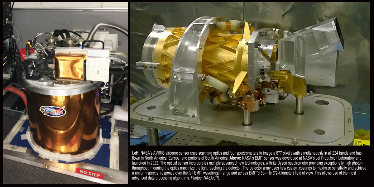
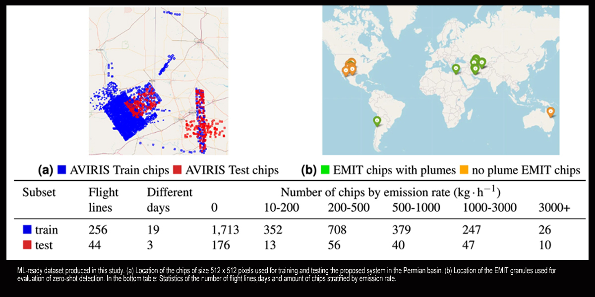
The researchers trained the model using 167,825 hyperspectral tiles (each representing an area of 1.64 km2) captured by NASA's aerial sensor AVIRIS over the Four Corners area of the U.S. The algorithm was then applied to data from other hyperspectral sensors in orbit, such as data collected from NASA's new hyperspectral sensor EMIT (Earth Surface Mineral Dust Source Investigation mission) which is attached to the International Space Station and provides near-global coverage of the Earth.
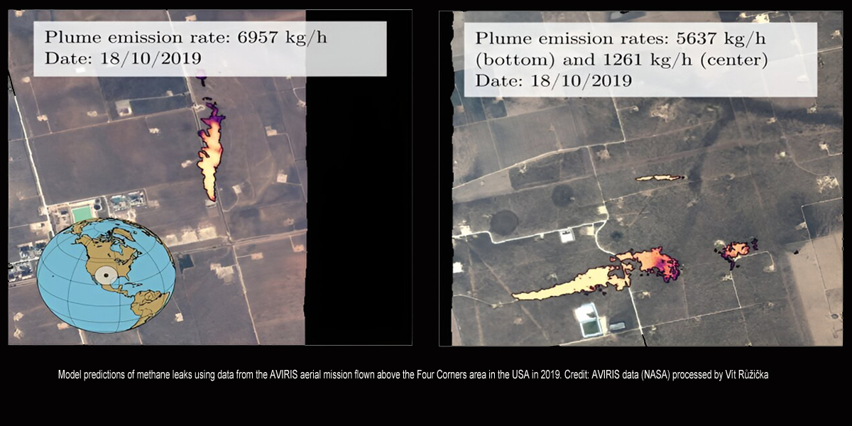
Overall, the model has an accuracy of more than 81% for detecting large methane plumes, and was 21.5% more accurate than the previous most accurate approach. The method also had a significantly improved false positive detection rate for tile classification, lowering it by about 41.83% in comparison with the previous most accurate approach.
To promote further research in methane detection, the researchers have open sourced both the annotated dataset and the code used for the model on the project page at GitHub. They are now exploring whether the model could operate directly onboard the satellite itself, allowing other satellites to conduct follow-up observations as part of the NIO.space initiative.
Lead researcher DPhil student Vít Růžička (Department of Computer Science, University of Oxford) said, "Such on-board processing could mean that initially only priority alerts would need to be sent back to Earth, for instance a text alert signal with the coordinates of an identified methane source. Additionally, this would allow for a swarm of satellites to collaborate autonomously: an initial weak detection could serve as a tip-off signal for the other satellites in the constellation to focus their imagers on the location of interest."
More information: Vít Růžička et al, Semantic segmentation of methane plumes with hyperspectral machine learning models, Scientific Reports (2023). DOI: 10.1038/s41598-023-44918-6. Journal information: Scientific Reports
Provided by University of Oxford
Subscribe to our newsletter
Stay updated on the latest technology, innovation product arrivals and exciting offers to your inbox.
Newsletter

