
LBS – Location Based Services
Don't miss a beat, sign up to our newsletter

Satellite Images show Europe's diversity in new book
3rd October 2017
Satellite Images show Europe's diversity in new book
Approaches and solutions for tomorrow’s transport
2nd October 2017
Approaches and solutions for tomorrow’s transport

Fugro Wins Highway Data Collection Contract for The State Of Alaska
30th September 2017
Fugro Wins Highway Data Collection Contract for The State Of Alaska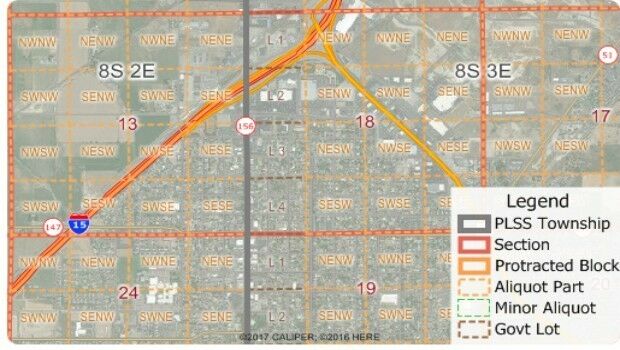
Free Public Land Survey System (PLSS) Data for Use with Maptitude
30th September 2017
Free Public Land Survey System (PLSS) Data for Use with Maptitude
Brainnwave Brings Unique Data Portal to Scotland Showcase
27th September 2017
Brainnwave Brings Unique Data Portal to Scotland Showcase
ArcGIS Pro Users 'Finding the Best Place for a Public Park'
26th September 2017
ArcGIS Pro Users 'Finding the Best Place for a Public Park'
SSTL announces NovaSAR-S data deal with Australia’s CSIRO
26th September 2017
SSTL announces NovaSAR-S data deal with Australia’s CSIRO
New Product Launches At Intergeo From GeoSLAM
25th September 2017
New Product Launches At Intergeo From GeoSLAM
OS to support Singapore as a smart technology world leader
25th September 2017
OS to support Singapore as a smart technology world leader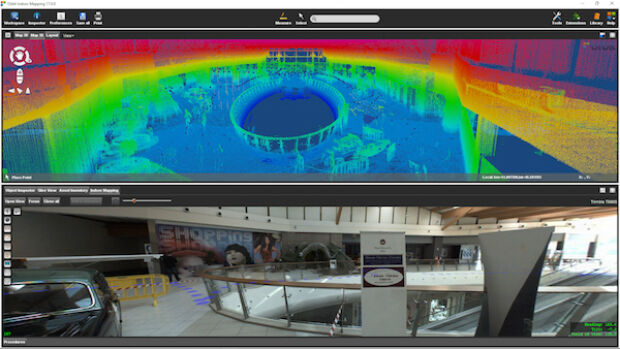
Orbit GT and Applanix, Canada, sign Reseller Agreement
25th September 2017
Orbit GT and Applanix, Canada, sign Reseller Agreement
Real-Time Construction Quality Management, Advanced
22nd September 2017
Real-Time Construction Quality Management, Advanced
2017 URISA Exemplary Systems in Government Award Recipients Announced
21st September 2017
2017 URISA Exemplary Systems in Government Award Recipients Announced
Wingtra partners with Kentucky-based Precision Capture
21st September 2017
Wingtra partners with Kentucky-based Precision Capture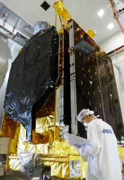
Airbus ships EchoStar 105/SES-11 telecom satellite to launch base
21st September 2017
Airbus ships EchoStar 105/SES-11 telecom satellite to launch base
Esri Podcast Series Explores How Location Technology Helps Businesses
19th September 2017
Esri Podcast Series Explores How Location Technology Helps Businesses
Marathon Des Sables to use SPOT Gen3 for new events
18th September 2017
Marathon Des Sables to use SPOT Gen3 for new events
ENA’s Open Networks will be hosting a free webinar on September 21
18th September 2017
ENA’s Open Networks will be hosting a free webinar on September 21
Hamburg and HERE to partner on intelligent mobility
17th September 2017
Hamburg and HERE to partner on intelligent mobility
3G Vehicle Cameras Prove Liability and Defend Against Claims
16th September 2017
3G Vehicle Cameras Prove Liability and Defend Against Claims
AND aims to redefine map making & change the mapping industry
11th September 2017
AND aims to redefine map making & change the mapping industry
SmarTrack Situational Awareness System for GPS Denied Environments
7th September 2017
SmarTrack Situational Awareness System for GPS Denied Environments
Airborne mapping system from 3D Laser Mapping takes off
6th September 2017
Airborne mapping system from 3D Laser Mapping takes off
Ricardo and Roke collaborate on vehicle cyber security
6th September 2017
Ricardo and Roke collaborate on vehicle cyber securityReal-time imagery for firefighters saves lives
23rd August 2017
Real-time imagery for firefighters saves lives
Garmin receives EASA approval for new GTN 650/750 features
18th August 2017
Garmin receives EASA approval for new GTN 650/750 features
KudanSLAM: 3D Recognition and Position Tracking Software
16th August 2017
KudanSLAM: 3D Recognition and Position Tracking SoftwareLarge Companies Target Energy Independent Electric Vehicles
15th August 2017
Large Companies Target Energy Independent Electric Vehicles
20 Years of Continuous, Failure-Free Operations
15th August 2017
20 Years of Continuous, Failure-Free Operations
Safety app to check-in with lone working staff around the clock
14th August 2017
Safety app to check-in with lone working staff around the clock
Digital Element’s location-based technology
14th August 2017
Digital Element’s location-based technology
Masternaut launches short-term hire vehicle telematics
10th August 2017
Masternaut launches short-term hire vehicle telematics
The Commercial UAV Show 15-16 November 2017 ExCel, London
9th August 2017
The Commercial UAV Show 15-16 November 2017 ExCel, London
Monroe County, Fla., Upgrades CompassCom Mobile Resource Management
9th August 2017
Monroe County, Fla., Upgrades CompassCom Mobile Resource Management
Taboola increases accuracy of mobile and desktop geolocation services
8th August 2017
Taboola increases accuracy of mobile and desktop geolocation services
Route Execution with Visibility of Sub-Contracted Vehicles Enhanced
8th August 2017
Route Execution with Visibility of Sub-Contracted Vehicles Enhanced
Oracle makes transportation more efficient with HERE
7th August 2017
Oracle makes transportation more efficient with HERE
WITec's RISE Microscopy Now Available with ZEISS Sigma 300 SEM
7th August 2017
WITec's RISE Microscopy Now Available with ZEISS Sigma 300 SEM
HR Wallingford and G-tec to provide underwater acoustic services
3rd August 2017
HR Wallingford and G-tec to provide underwater acoustic services
TrackR Closes $50m in Series B Funding led by Revolution Growth
2nd August 2017
TrackR Closes $50m in Series B Funding led by Revolution Growth
Free Point of Interest Data by Type for Use with Maptitude
29th July 2017
Free Point of Interest Data by Type for Use with Maptitude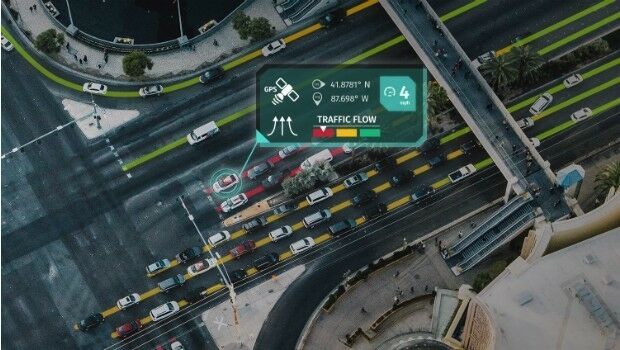
HERE launches supercharged Real-Time Traffic service
27th July 2017
HERE launches supercharged Real-Time Traffic service
Hampshire firefighters and public safer with integrated communications
25th July 2017
Hampshire firefighters and public safer with integrated communicationsGarmin Pilot adds synthetic vision to Android mobile devices
21st July 2017
Garmin Pilot adds synthetic vision to Android mobile devices
Dennis Eagle launches StaySafe panic alarm app
21st July 2017
Dennis Eagle launches StaySafe panic alarm app