News
News as it happens! Keep in touch with the latest developments in business and technology in the regions or worldwide.
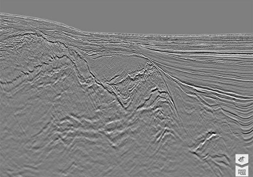
CGG Delivers Final PSDM Products for Cairenn Multi-Client Survey
30th October 2017
CGG Delivers Final PSDM Products for Cairenn Multi-Client Survey
Smart Cities Will Not Thrive Without National Policy Support
30th October 2017
Smart Cities Will Not Thrive Without National Policy Support
Helping Councils get the Most from Infrastructure Asset Management
30th October 2017
Helping Councils get the Most from Infrastructure Asset Management
Three new exciting webinars are now opened for registration
30th October 2017
Three new exciting webinars are now opened for registration
WorldView Global Alliance User Conference 2017 Report
28th October 2017
WorldView Global Alliance User Conference 2017 Report
OGC supports American Geographical Society’s 2017 Fall Symposium
27th October 2017
OGC supports American Geographical Society’s 2017 Fall Symposium
Topcon helps DEC! develop maths skills that are fit for site
27th October 2017
Topcon helps DEC! develop maths skills that are fit for site
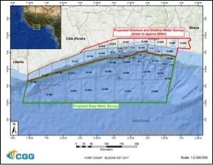
CGG Awarded Contract for Licenses in Côte d’Ivoire
26th October 2017
CGG Awarded Contract for Licenses in Côte d’Ivoire.jpg)
Fugro Applies Seeps Expertise To Canada’s Growing Offshore Industry
26th October 2017
Fugro Applies Seeps Expertise To Canada’s Growing Offshore Industry
Commercial UAV Expo and Drone World Expo Come Together in 2018
26th October 2017
Commercial UAV Expo and Drone World Expo Come Together in 2018
Smart City Capabilities at Smart City Expo World Congress 2017
26th October 2017
Smart City Capabilities at Smart City Expo World Congress 2017
GfK releases updated maps for all of Europe
26th October 2017
GfK releases updated maps for all of Europe
OS International partners with Tanzania and the World Bank
26th October 2017
OS International partners with Tanzania and the World Bank
Orbit GT updates 3D Mapping Cloud with great new UAV support
26th October 2017
Orbit GT updates 3D Mapping Cloud with great new UAV support
PCI Geomatics Signs MOU with AGH University, in Krakow, Poland
26th October 2017
PCI Geomatics Signs MOU with AGH University, in Krakow, Poland
Tulloch Mapping Purchases the FIRST RIEGL VMX-2HA!
26th October 2017
Tulloch Mapping Purchases the FIRST RIEGL VMX-2HA!
Okeanus Upgrades Nortek Signature55 System
26th October 2017
Okeanus Upgrades Nortek Signature55 System
New OGC standard improves the reference for Earth Information
26th October 2017
New OGC standard improves the reference for Earth Information
Saudi Ministry of Interior Supports Hajj and Umrah Safety with Hexagon Solution
25th October 2017
Saudi Ministry of Interior Supports Hajj and Umrah Safety with Hexagon Solution
New Supply-Chain Accessories for the NAUTIZ X2
25th October 2017
New Supply-Chain Accessories for the NAUTIZ X2
Bluesky's Tree Map Helps Community Forest Rebuild Environment
25th October 2017
Bluesky's Tree Map Helps Community Forest Rebuild Environment
VSTEP provide CAE with bridge simulators for UAE Naval Training Centre
24th October 2017
VSTEP provide CAE with bridge simulators for UAE Naval Training Centre