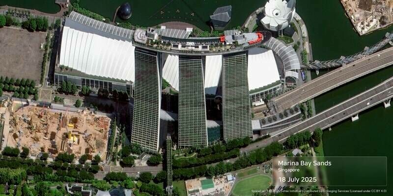
News
News as it happens! Keep in touch with the latest developments in business and technology in the regions or worldwide.


XenomatiX extends its road scanning capabilities
12th September 2023
XenomatiX extends its road scanning capabilities
Microsoft Collaborates with SimActive on a Cloud Photogrammetry Solution
11th September 2023
Microsoft Collaborates with SimActive on a Cloud Photogrammetry Solution
German Start-up Rasdaman GmbH and Airbus Defence and Space Team Up on Datacubes
11th September 2023
German Start-up Rasdaman GmbH and Airbus Defence and Space Team Up on Datacubes
TDI-Brooks Completes Phase Four Geotechnical Program In The Black Sea
8th September 2023
TDI-Brooks Completes Phase Four Geotechnical Program In The Black Sea
Fugro’s Geo-data drives smart road maintenance strategies in South Carolina
8th September 2023
Fugro’s Geo-data drives smart road maintenance strategies in South Carolina
World Hydrogen Week sees launch of world-first H2 derivative programme
7th September 2023
World Hydrogen Week sees launch of world-first H2 derivative programme
Space Flight Laboratory (SFL) Announces Performance Milestone for GHGSat Greenhouse Gas Monitoring Microsatellites
7th September 2023
Space Flight Laboratory (SFL) Announces Performance Milestone for GHGSat Greenhouse Gas Monitoring Microsatellites
Bluesky 3D Imagery Brings Global Warming Sea Level Rises to Life
7th September 2023
Bluesky 3D Imagery Brings Global Warming Sea Level Rises to Life
u-blox introduces its first multi-mode cellular and satellite IoT module with embedded positioning
6th September 2023
u-blox introduces its first multi-mode cellular and satellite IoT module with embedded positioning
EUSI Partners with Umbra to Offer SAR Imagery to European Remote Sensing Projects
6th September 2023
EUSI Partners with Umbra to Offer SAR Imagery to European Remote Sensing Projects
GIS People Introduces Free Educational eBook: Open-Source GIS vs Commercial GIS
5th September 2023
GIS People Introduces Free Educational eBook: Open-Source GIS vs Commercial GIS
Aeronautics Secures a $40M Contract to Supply its Orbiter 1K Loitering Munition UAS to an International Customer
5th September 2023
Aeronautics Secures a $40M Contract to Supply its Orbiter 1K Loitering Munition UAS to an International Customer
Hexagon reaches new heights with launch of BLK2FLY Autonomous Indoor Scanning
4th September 2023
Hexagon reaches new heights with launch of BLK2FLY Autonomous Indoor Scanning
LAKE FUSION Technologies and Innovusion Europe Partner for the Launch of a Cutting-Edge Situational Awareness System for Civilian Helicopters
4th September 2023
LAKE FUSION Technologies and Innovusion Europe Partner for the Launch of a Cutting-Edge Situational Awareness System for Civilian Helicopters
Getech heads into Orbit as Planet partner
4th September 2023
Getech heads into Orbit as Planet partner
Bluesky Aerial Data Helps CGL Pinpoint Natural Hazards at Development Sites
1st September 2023
Bluesky Aerial Data Helps CGL Pinpoint Natural Hazards at Development Sites
EuroGeographics and International Cartographic Association agree collaboration to unlock power of location
1st September 2023
EuroGeographics and International Cartographic Association agree collaboration to unlock power of location
INTERGEO 2023: New "Unmanned Systems" format spotlights UAV technologies
31st August 2023
INTERGEO 2023: New "Unmanned Systems" format spotlights UAV technologies
Bentley Systems Announces the Finalists of the 2023 Going Digital Awards in Infrastructure
31st August 2023
Bentley Systems Announces the Finalists of the 2023 Going Digital Awards in Infrastructure
Teledyne FLIR Introduces Lepton 3.1R Radiometric Thermal Camera Module for Integrators
30th August 2023
Teledyne FLIR Introduces Lepton 3.1R Radiometric Thermal Camera Module for Integrators
Flood Hazard Web GIS in Japan Developed with TatukGIS SDK
30th August 2023
Flood Hazard Web GIS in Japan Developed with TatukGIS SDK
RIEGL Australia Appoints Synergy Positioning Systems as a Terrestrial LiDAR Distributor in New Zealand
29th August 2023
RIEGL Australia Appoints Synergy Positioning Systems as a Terrestrial LiDAR Distributor in New Zealand
I/NAV improvements are now available to all Galileo Open Service users
29th August 2023
I/NAV improvements are now available to all Galileo Open Service users