Share
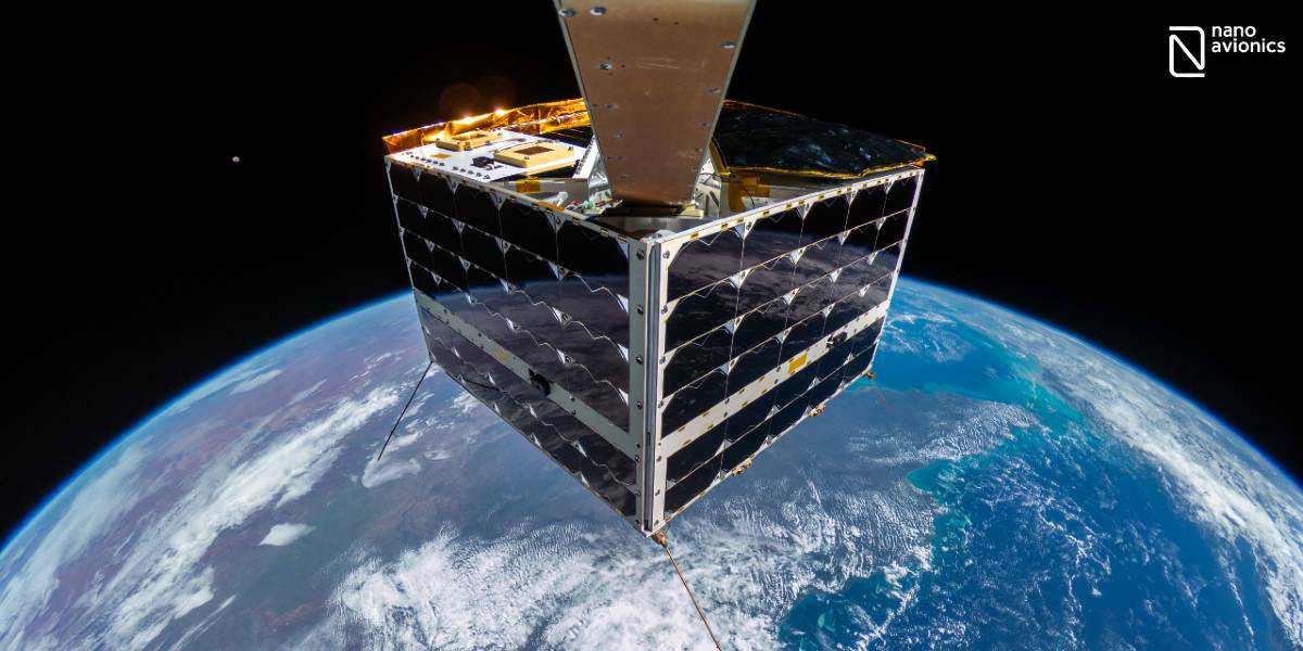
NanoAvionics have used an off-the-shelf consumer camera, mounted on a selfie stick, to take the first ever 4K resolution full satellite selfie in space with an immersive view of Earth.
In addition to the stunning imagery, NanoAvionics used the camera to test and verify satellite operations and their new payload controller, designed to optimise downlink for applications that require onboard processing of huge data packages. The company anticipates more future usages of real satellite footage, live and recorded, such as deployment confirmation, fault detection, micro-meteorite impacts and educational purposes. The satellite was launched for NanoAvionics’s MP42 microsatellite bus heritage mission aboard a SpaceX Falcon F9 in April this year.
Vytenis J. Buzas, co-founder and CEO of NanoAvionics, said: “The reason for taking the photo and video clip with the Great Barrier Reef in the background was partly symbolic. We wanted to highlight the vulnerability of our planet and the importance of Earth observation by satellites, especially for monitoring environment and climate changes.
“In our increasingly visual culture, it is important for investors, students, customers and the general public to see in order to believe. Millions watch rocket launches but barely see satellites moving in orbit or deployable structures in operation. This is going to change through live or recorded footage.”
NanoAvionics chose a consumer camera because typical space-grade engineering cameras either don’t have enough resolution, are costly, need months to develop and cannot always provide an immersive view of Earth. To operate the camera in space, NanoAvionics had to strip it down the to its bones. Engineers then fabricated a custom housing for the electronics, made a custom ‘selfie stick’ and developed camera control electronics and special software to communicate with the satellite systems. They also tested it rigorously to prove it can survive the harsh environment of a rocket launch as well as the vacuum and huge temperature swings in space.
Off-the-shelf consumer action cameras are not frequently used in satellite missions but for NanoAvionics it was a quick and visually appealing way to do initial satellite and components tests including their new generation PC 2.0 payload controller running on Linux. The company’s engineers used the data heavy images and videos during LEOP (launch and early orbit phase) to verify the new controller is ready for advanced applications that require onboard processing of large amounts of data.
“Transmitting several GB of images and videos when operating the camera with pre-programmed starts and stops from the ground was as data heavy as it gets,” said Ernestas Kalabuckas, chief technology officer of NanoAvionics. “In addition to receiving telemetry and technical reports, being able to access live images and videos of the satellite is useful to visually confirm the deployment of antennas and other deployable structures, and for ongoing fault detection. Comparing selfie images over time can also enable the detection of visual clues about possible degradation of materials or micro-meteorite impacts.”
Due to the combined quality improvement of footage showing satellite deployment from cameras aboard launch vehicles and high-resolution footage from satellites also equipped with cameras, the company expects to see many benefits watching satellites in orbit.
“Photos and videos of satellites circling our planet could draw more attention and help more people and organisations to realise the societal, economic, educational and environmental benefits that satellites provide,” Buzas said. “It could also inspire more people to take up careers in the rapidly growing space industry. We also still face the popular misconception that space is only accessible to large governments and select businesses. The truth is space is becoming much more commonplace thanks to reduced launch costs and the growing popularity, capabilities and use cases of small satellite constellations. Satellites in low Earth orbits can detect and monitor chemical spills, illegal fishing, wildfires, crop growth as well as track and ultimately help saving endangered animals.
“High-resolution imagery might also change the way companies market their space components such as antennas, new propulsions systems, solar sails and robotic arms. Changing from artistic, computer-generated visualisations and animated videos to actual photos and recorded clips of satellites in space.”
Subscribe to our newsletter
Stay updated on the latest technology, innovation product arrivals and exciting offers to your inbox.
Newsletter

