Share
A new interactive swipe map of London shows the city in a new and engaging way.
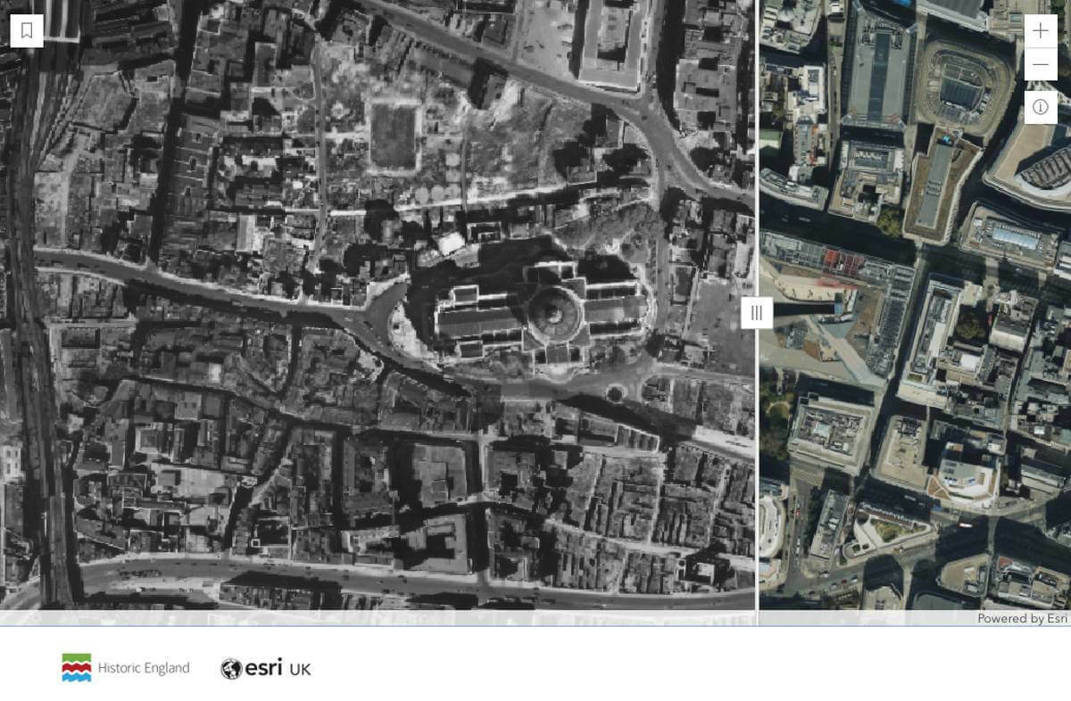
Using aerial photographs over 70 years old from the Historic England Archive, along with present day high-definition aerial imagery, the map instantly reveals what the city looked like at around the same time as the Queen’s Coronation on 2 June 1953, compared to today.
Bomb damage surrounding St Paul’s Cathedral or where the Barbican now stands, to an unrecognisable City of London or South Bank, are among some of the most surprising differences.
Created by mapping and analytics company Esri UK, working in collaboration with Historic England, the map has been developed to celebrate the Queen’s Platinum Jubilee.
Spanning central London, the map shows Buckingham Palace in the west to Whitechapel in the east. Viewers navigate the map by using bookmarks, panning, or zooming, while a slider function allows an instant comparison of old images from the late 1940s with those from the present day, revealing how much London has changed since Her Majesty’s Coronation.
Key sites visible on the map include:
*Buckingham Palace – not much appears to have changed at this landmark, even the pattern of the flowerbeds around the Queen Victoria Memorial remains the same
*The South Bank – showing the old wharfs and barges
*St Paul’s Cathedral – surrounded by levelled bomb sites
*Barbican Centre – an area heavily bombed in the war
*Liverpool Street Station – much of the station and sidings are now covered by office blocks
*The British Museum – clearly showing the once open courtyard
*The Gherkin – the City of London is unrecognisable in 1948
*The Tower of London – a once empty St Katharine Docks is today full of boats
*London Bridge Station – dozens of old barges once moored where HMS Belfast is now stationed
To create the map, Esri UK used images from Historic England Archive, which holds the most detailed and comprehensive source of aerial photography of London. The photographs used are from Royal Air Force (RAF) survey flights in 1948, the closest date available to when the Queen was proclaimed Queen in 1952 and Her Coronation in 1953. These photographs were taken by the RAF following the Second World War to record and assess bomb damage and to help rebuild the city. Esri UK used its drone image processing software to stitch together over 400 photos to make the interactive map. This software is normally used in industries such as construction, defence, or emergency services to share and analyse images captured by drones, aircraft and satellites.
“Exploring London with this historic map of the 1940s, side-by-side with the London of today is a fascinating experience,” said Charles Kennelly, Chief Technology Officer, Esri UK. “We can see how much has changed in the place we know, but also how much of what we take for granted is built upon the legacy we have been given. The technology we use makes this process easy and engaging and brings Historic England’s valuable data and insight to a much wider audience.”
Creating large maps from aerial imagery from planes or drones relies on having high quality images and knowing where they were taken. Historic England’s work to digitise the The Royal Air Force’s 1948 survey imagery has created a unique digital archive with enough images from the time of the Coronation to make the new map possible. The Historic England Archive contains over six million aerial photographs, 400,000 of which have been digitised and are available to view for free on the Aerial Photography Explorer.
Duncan Wilson, Chief Executive, Historic England said: “We are pleased that images from our recently-launched online Aerial Photography Explorer have been used in this innovative way to shine a light on these important archive aerial views of London. We hope people find this new interactive map an engaging way to understand more about the development of our capital city since Her Majesty ascended the throne.”
Subscribe to our newsletter
Stay updated on the latest technology, innovation product arrivals and exciting offers to your inbox.
Newsletter

