Share
Cutting-edge reality capture technology from Leica Geosystems, part of Hexagon, is digitally preserving the 17th century Citadelle de Besançon, France, a UNESCO World Heritage Site, while allowing visitors to immerse themselves in the area’s rich history.
A joint project of the French Government and Capture4Cad is using laser scanners from the Leica Geosystems’ BLK autonomous reality capture portfolio to create a comprehensive 3D model of the massive structure. Digitalising the citadel will help preserve it and enable more visitors to experience its history through augmented reality.
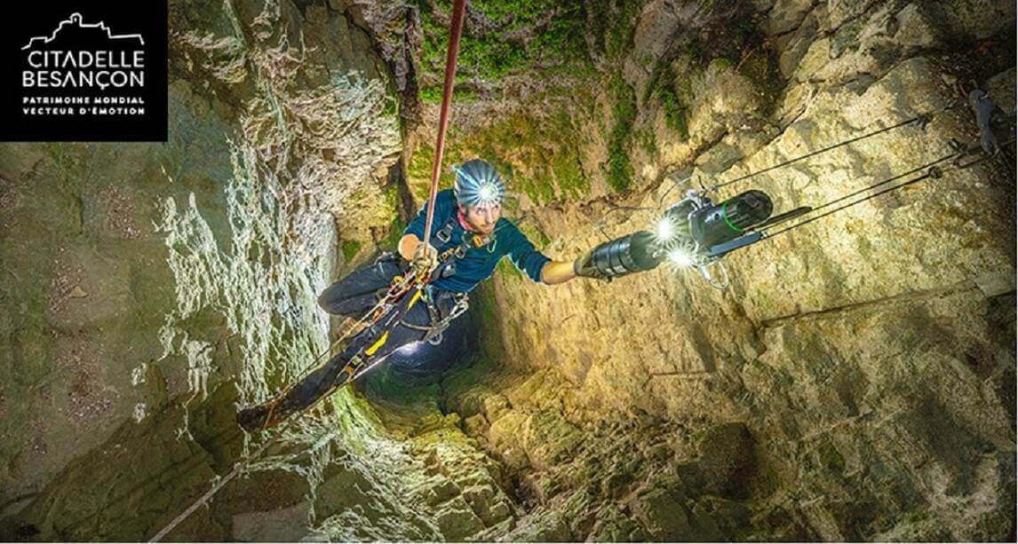
Capture4Cad had to navigate several challenges whilst collecting the data, including the sheer size of the citadel. Many areas are inaccessible, and the team had to avoid disruption to visitors and animals on site. Using a range of scanners, Capture4Cad was able to cover the whole site within a tight timeframe. The Leica BLK2FLY autonomous flying scanner captured the towering ramparts, sheer cliffs, roofs and facades of the citadel. The versatile Leica BLK ARC was steadily lowered 120 metres into France’s deepest well to thoroughly map the well shaft. The BLK ARC was also mounted to Boston Dynamics’ autonomous robotic carrier to independently map the grounds of the citadel. In the underground tunnels, the handheld Leica BLK2GO scanner provided uninterrupted scanning on the move.
"The range of Leica BLK autonomous scanners was essential to create the reality capture model of this expansive and intricate site,” said Hugo Parent, Head of the Heritage Department at Capture4Cad. “From capturing the point clouds to generating the 3D model, we’ve used Leica Geosystems solutions throughout this project to bring all the elements together.”
HxDR, Hexagon’s cloud native platform for geospatial data at any scale, connects the data captured throughout the citadel to deliver a live model in the cloud. The Leica Cyclone software suite seamlessly processed the scan data into a highly detailed 3D model of the citadel above and below ground. Moving forward, the model will be used with software from Immersal to create an augmented reality experience for visitors to travel back in time.
Leica Geosystems' Giuseppe Mazzara, Director Sales Development, BLK Autonomy, said, “this ambitious project highlights how autonomous scanning solutions are uniquely positioned to help companies like Capture4Cad access complex sites to capture and process huge amounts of data. We are proud to play a part in telling the Citadelle de Besançon’s rich 400-year history and preserving it for future generations.”
For more information on the project, explore our website and watch the video.
Subscribe to our newsletter
Stay updated on the latest technology, innovation product arrivals and exciting offers to your inbox.
Newsletter

